BGS PRIME: an early warning system for slope failure
Dam and slope failures can lead to the wide-scale destruction of property and, in some cases, catastrophic loss of life.
13/01/2021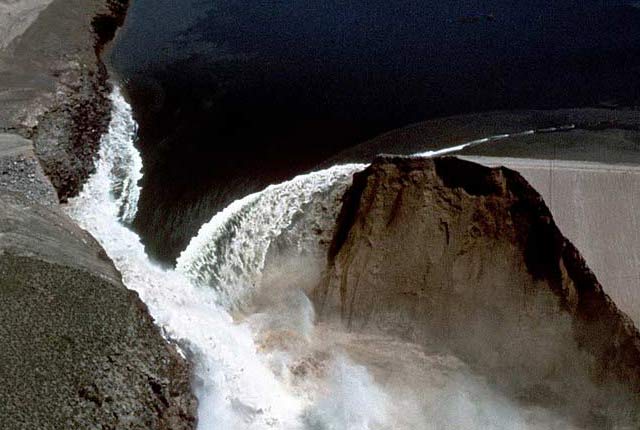
Dam and slope failures can lead to the wide-scale destruction of property and, in some cases, catastrophic loss of life. For example, an estimated 170 000 people were killed in the Banqiao dam failure in China in 1975.

The BGS-developed PRoactive Infrastructure Monitoring and Evaluation (PRIME) system is a ground imaging system that can remotely monitor the integrity of infrastructure assets such as dams, cuttings and embankments. PRIME uses technology similar to medical imaging, which can give an early warning that a dam wall may be developing faults that cannot be seen by inspection of its surface.
Already deployed in research projects around the world, PRIME is a low-cost, low-power system controlled using wireless technology. PRIME can be rapidly deployed to provide subsurface information and can save time and money when compared to ‘walk-over’ surveys.
Depending on the size and scale of the event, failed embankments have the potential to cause millions of pounds’ worth of damage to railway, road or canal networks. To illustrate the scale of this issue, in the UK:
- Network Rail is responsible for around 190 000 earthwork assets
- Highways England is responsible for 6500 km of highway, including unstable slopes
- the Environment Agency is responsible for 7500 km of coastal and river flood embankments
- there are around 2800 dams in the UK alone
Network Rail have identified PRIME as a technology that has the potential to contribute to the strategic remote condition monitoring and assessment of ‘at risk’ earthwork assets, specifically with respect to identifying potentially unstable slope conditions in soil embankments. We are therefore very pleased to be trialling the technology at sites in the Southern region over a three-year period.
Gavin Jessamy, Network Rail (Civil Engineer – Building and Civils, PRIME Project Manager)
There is a growing recognition among asset owners, managers and consultants that remote monitoring technologies have the potential to reduce failure costs and risks by providing continuous condition information and early warnings.


Brumadinho dam collapse, Brazil, 25 January 2019. Over 170 people lost their lives as 11.7 million m3 of toxic mud was released into the valley below. Some viewers may find the footage distressing. Source: Guardian News.
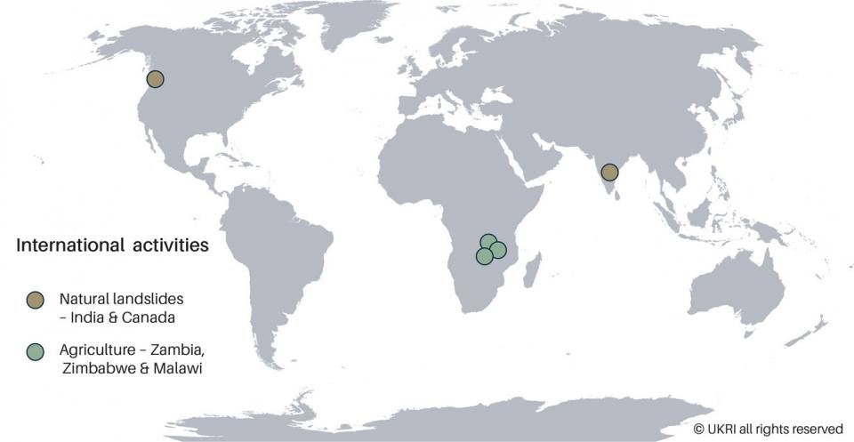
In the UK, Network Rail has deployed PRIME technology to monitor water content in 4D, across rail cuttings as part of their Earthworks Technical Strategy, 2018. Elsewhere in world, PRIME has been deployed in Canada and India to monitor landslides that may affect railway embankments.
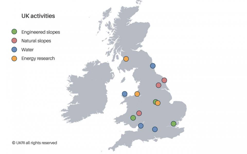

PRIME works by making hundreds or thousands of individual electrical measurements from the sensor arrays deployed at the ground surface or within boreholes, which are used to construct images of the subsurface resistivity distribution. The system is controlled remotely, using telemetry to schedule measurements and retrieve data.
PRIME can image:
- variations in ground composition
- changes in groundwater saturation
- presence of contaminants
- changes in ground volume caused by increase in moisture
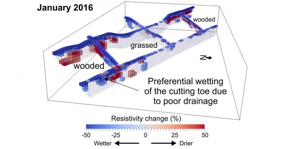
PRIME imaging of an operational railway cutting showing seasonal subsurface moisture dynamics, including the drying effect of heavily vegetated areas and preferential drainage to areas at the bottom of the slope. January 2016. BGS © UKRI. All rights reserved.
PRIME was the winner of the Ground Engineering Awards 2016 and the Highways UK Intelligent Infrastructure Challenge 2019.

PRIME represents a real step change in the practice of proactive asset management, delivering invaluable data on moisture levels and movement, without the need for intrusive investigation techniques.
Nick Slater, Director of Monitoring Services, SOCOTEC
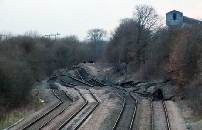
Network Rail tracks affected by Hatfield Colliery landslide, 23 February 2013. BGS © UKRI. All rights reserved.
Background and policy aims
Since 2014, the development of PRIME has been driven by the increasing rate and severity of infrastructure earthwork failures. This is due to aging assets (many canal and rail earthworks are over a hundred years old) and more extreme weather events (e.g. the extreme rainfall during winter 2013–4). Asset failures are enormously expensive, costing hundreds of millions of pounds per year in the UK alone, not to mention risks to human health and disruption of services, transport systems and the wider economy.
Many infrastructure assets were constructed a long time ago, to no recognisable engineering standards and often using less than appropriate materials. These assets, when put under environmental pressures such as excessive rainfall, can become challenging to manage. PRIME was developed to provide a remote condition-monitoring and decision-support system for assessing the internal physical condition of safety-critical geotechnical assets, such as embankments, cuttings and dams.
Prof Jonathan Chambers, British Geological Survey
PRIME has the potential to generate significant commercial revenue for the BGS on a worldwide scale, to improve safety and to reduce maintenance costs for infrastructure owners. In 2019, PRIME was licensed to SOCOTEC, a provider of testing, inspection and compliance services, in a two-year, non-exclusive contract.
Addressing the UN Sustainable Development Goals (SDGs)

PRIME is being used in agricultural research (tracking moisture dynamics in the soil) to better understand the benefits/limitations of conservation agriculture in Africa.

Dams have a critical role in the supply of water, particularly in developing countries in arid parts of the world that have chronic supply problems. PRIME is being used for monitoring water supply infrastructure (dams; buried pipes, etc.) and is also sensitive to the presence of contaminants and so is a tool for assessing and monitoring groundwater quality.

Hydroelectric power from dams has an important role to play in achieving affordable and clean energy. PRIME has applications in monitoring energy-related problems (and is therefore being deployed extensively in the UK Geoenergy Observatories) e.g. carbon capture and storage; geothermal, etc.

PRIME has an important role to play in working towards SDG 9, i.e. developing reliable and resilient transport infrastructure. The principal application of PRIME to date has been as an innovative technology for monitoring critical infrastructure earthworks within transportation and utilities networks.

PRIME has an important role to play in working towards SDG 11 in improving safety within public transport rail networks. PRIME has been used extensively for monitoring in the built environment. This includes landslide monitoring to assist vulnerable communities in south-east Asia.

PRIME is used for monitoring the impacts of changing climate on the critical zone (i.e. near surface), including monitoring permafrost processes and glacial retreat in the Arctic (Alaska and Norway).
Project partners
- Arup
- AtkinsRéalis
- The Canal and River Trust
- Environment Agency
- Highways England
- HS2
- Kier
- National Grid
- Network Rail
- RSSB
- Scottish Canals
- SOCOTEC Monitoring UK Ltd (formerly ITM Monitoring)
- Transport Scotland


