BGS Civils: excavatability
- 1:50 000
- Great Britain
- Premium
The BGS Civils excavatability theme provides information on the excavatability of geological deposits at surface. Excavations are dug for a range of civil engineering purposes including cuttings, borrow pits and quarries. Typically, excavations to 2 to 3 m are for foundations, utilities infrastructure, cellar construction, grading and burial pits.
Key information
- Scale:
- 1:50 000
- Coverage:
- Great Britain
- Availability:
- Premium
- Price:
BGS Civils bundle (all eight layers) £0.58 per km2
BGS Civils individual layers £0.35 per km2
Subject to number of users, licence fee and data preparation fee.
- Format:
- GIS line and polygon data (ESRI, MapInfo, others available by request)
- Uses:
- Local-level use
- Themes:
- Built environment, Engineering geology
BGS Civils is a suite of national maps of engineering properties based on geological data and the digital 1:50 000-scale geological map — BGS Geology 50K.
It comprises eight layers:
- bulking volume
- corrosivity (ferrous)
- discontinuities
- engineered fill
- excavatability
- foundation conditions
- strength
- sulfate/sulfide
The primary goal of the product is to provide the key engineering characteristics of the geology of Great Britain to professional users who need simple and rapid access to such information. You might be planning pipeline routes avoiding difficult ground conditions, calculating tender costs for trench excavation or you might need knowledge of ground properties in order to plan your daily activities.
The data is provided as GIS shapefiles that are available to licence individually or as a bundle to meet your own requirements.

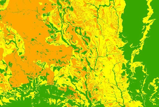
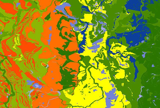
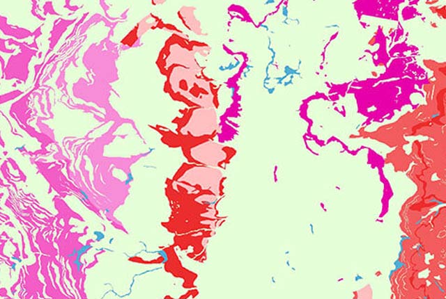
BGS Civils: exacavatability coverage. BGS © UKRI – Contains OS data © Crown copyright 2020.
This dataset
This theme provides information on the excavatability of geological deposits at surface. The values supplied are the indicative minimum, maximum and typical values we would normally expect to encounter per geological unit but limited to the top 2–3 m.
The spatial model covers England, Scotland and Wales at 1:50 000 scale and is based upon bedrock and superficial geology from BGS Geology 50K, archive data of engineering soil strength from the National Geotechnical Properties Database coupled with the Soil Parent Material Map and displayed via dictionaries of ‘excavatability classes’.
What is excavatability?
Excavations are dug for a range of civil engineering purposes including cuttings, borrow pits and quarries. Typically excavations to 2–3 m are for foundations, utilities infrastructure, cellar construction, grading and burial pits.
Excavatability is a measure of how easy it is to remove earth materials and is used to determine appropriate excavation methods. It is a function of the geotechnical properties of the material (strength or density) and mass characteristics, in particular mechanical discontinuities.
The stronger the material, the more difficult it is to penetrate, break and consequently remove. However, mechanical weaknesses, in particular discontinuities, are exploited to aid excavation. A very strong rock may be readily excavatable if it has closely spaced discontinuities while a moderately strong rock with widely spaced discontinuities may require greater effort to excavate.
Additional factors that may affect excavatability include the maximum depth of penetration, bulk density, bulking volume and susceptibility to running (flow).
Definition
The description and classification of excavatability depends on the type of deposit. In engineering geology, earth materials are split into two groups: soils and rocks.
Soil
Soil is an aggregate of mineral grains or organic material that can be separated by gentle means such as agitation in water. Soil behaviour is determined by the particulate nature (specifically the particle size, shape and mineralogy), water content and material density. The mass properties of a soil are largely influenced by its material characteristics.
The principal soil types are clay, silt (fine soils), sand, gravel (coarse soils), cobble and boulder (very coarse soils). Whether the soil is classified principally as fine or coarse is dependent upon the behaviour of the material. Discontinuities affect the mass strength of some soils, primarily clay and silt.
Rock
Rock is an aggregation of minerals connected by strong and permanent forces. The behaviour of the rock material depends on the material characteristics. The behaviour of the rock mass depends on a combination of the material characteristics and the discontinuities including spacing, roughness, persistence, filling, orientation and the number of sets.
Classification
The categorisation of excavatability is based on strength data collated for geological formations as identified in the BGS Lexicon of Named Rock Units (LEX) and the BGS Rock Classification Scheme (RCS). The strength data is derived from the BGS Civils: strength dataset and from the British Standards Institute (1999) code of practice for site investigation (amended in 2003 and 2009). The classification has been further subdivided to account for regional/lateral geological variation where sufficient data exists. The degree of weathering of the geological unit has also been incorporated where possible.
You may also be interested in
BGS Civils: bulking volume
BGS Civils is a suite of national maps of engineering properties based on geological data and the digital 1:50 000 scale geological map – BGS Geology 50k.
BGS Civils: corrosivity (ferrous)
The BGS corrosivity dataset is a GIS layer supporting the management of underground iron assets that has been created in response to the growing awareness of the cost of maintenance of structures such as pipelines and building foundations.
BGS Civils: discontinuities
This theme provides information on the discontinuities in bedrock and superficial deposits as part of a suite of GIS layers for different engineering parameters.
BGS Civils: engineered fill
This theme provides information on the suitability of a geological material to be used as engineered fill.
BGS Civils: foundation conditions
This theme provides information on the suitability of a geological material for foundations as part of a suite of GIS layers for different engineering parameters.
BGS Civils: strength
This theme provides information on zones of rock strength and the local factors controlling it, as part of a suite of GIS layers for different engineering parameters.
BGS Civils: sulfate/sulfide potential
The BGS Civils: sulfates and sulfides dataset is a GIS layer that supports the management of underground assets
Infiltration SuDS map
The BGS Infiltration SuDS map dataset is suitable for those involved in the design of sustainable drainage systems and approving SuDS planning applications.

Permeability
Permeability data is often used in studies of groundwater. Our permeability information is based on BGS Geology 50K data.
Superficial deposit thickness model
The superficial deposit thickness model shows the depth of the bedrock surface below unconsolidated deposits