BGS Civils: bulking volume
- 1:50 000
- Great Britain
- Premium
The BGS Civils bulking factor theme classifies geological deposits at surface by their likely bulking factor. Bulking occurs when a geological material is excavated and the volume of disturbed material is different to the volume of the excavated hole. This is an important consideration in the civil engineering and extractive industries.
Key information
- Scale:
- 1:50 000
- Coverage:
- Great Britain
- Availability:
- Premium
- Price:
BGS Civils bundle (all eight layers) £0.58 per km2
BGS Civils individual layers £0.35 per km2
Subject to number of users, licence fee and data preparation fee.
- Format:
- GIS line and polygon data (ESRI, MapInfo, others available by request)
- Uses:
- Local-level use
- Themes:
- Built environment, Engineering geology
BGS Civils is a suite of national maps of engineering properties based on geological data and the digital 1:50 000-scale geological map — BGS Geology 50K.
It comprises eight layers:
- bulking volume
- corrosivity (ferrous)
- discontinuities
- engineered fill
- excavatability
- strength
- sulfate/sulfide
- foundation conditions
The primary goal of the product is to provide the key engineering characteristics of the geology of Great Britain to professional users who need simple and rapid access to such information. You might be planning pipeline routes avoiding difficult ground conditions, calculating tender costs for trench excavation or you might need knowledge of ground properties in order to plan your daily activities.
The data is provided as GIS shapefiles that are available to licence individually or as a bundle to meet your own requirements.

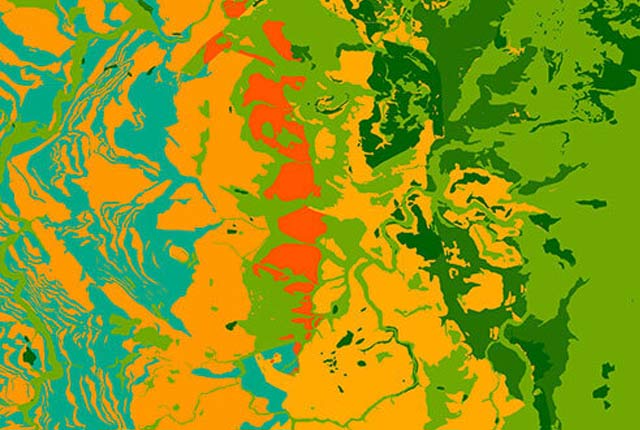
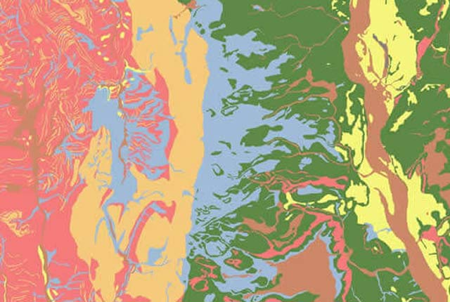
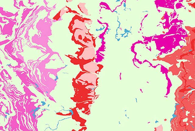
BGS Civils: bulking volume coverage. BGS © UKRI — Contains OS data © Crown copyright 2020.
This dataset
This theme classifies geological deposits at surface by their likely bulking factor. Bulking occurs when a geological material is excavated and the volume of disturbed material is different to the volume of the excavated hole.
The spatial model covers Great Britain at 1:50 000 scale and is based upon the BGS Lexicon of Named Rock Units (LEX), the BGS Rock Classification Scheme (RCS) and estimations of bulking factor values (available from literature review and web-based resources).
The ‘bulking of excavated material’ of rocks and soils is an important consideration in the civil engineering and extractive industries. The change in volume between in situ material and excavated material has implications for storing material in stockpiles on site or moving it off site.
What is bulking?
Bulking is defined as the increase in volume of material when it is excavated from its in situ location. The change in volume is called ‘bulking’ and the measure of the change is the ‘bulking factor’.
The bulking factor is the ratio or percentage of the volume change of excavated material to the volume of the original in situ volume before excavation. The bulking factor is used to estimate the likely excavated volumes that will need to be stored on site or perhaps removed from site. The bulking factor can be used to help mange the footprint and volumes of excavated materials as well as calculate vehicle movements (based on their carry capacity).
Bulking is controlled by the type of material (lithology) and the excavation methods used.
Lithological controls
The factors to consider are:
- Rock type or lithology: including grain structure and the propensity of a rock to disaggregate during excavation. The lower the disaggregation the greater the likelihood is of excavated material being poorly sorted with a relatively high bulking factor compared to material that is more disaggregated and better sorted.
- In situ porosity or density: if some of the pore spaces of the intact rock collapse when it breaks up, the bulking factor may be reduced.
- Particle size distribution: a poorly sorted material tends to exhibit a higher bulking factor. Bulking factor has been shown to be insensitive to the maximum particle size but is related to particle size distribution of a similar shape. Fine particles, such as those from the breaking of rock, reduce the bulking factor.
- Resultant particle shape: smaller thickness to width ratios tend to have lower values than more equidimensional blocks.
- Rock strength: stronger rocks have a greater bulking factor than weaker ones, where the rock is likely to break during excavation and so producing a greater variation in particle size distribution, producing a lower bulking factor.
Some soils have very low density and high water content, approaching or above the liquid limit, that may flow when emplaced after excavation and will not change volume significantly.
Excavation methods
The method of excavation will also have an effect on the bulking factor. The main methods of excavation are digging (easy or hard), ripping, hydraulic hammer or blasting. The method of excavation depends primarily on the mechanical discontinuity (joints) spacing and the strength of the rock.
You may also be interested in
BGS Civils: corrosivity (ferrous)
The BGS corrosivity dataset is a GIS layer supporting the management of underground iron assets that has been created in response to the growing awareness of the cost of maintenance of structures such as pipelines and building foundations.
BGS Civils: discontinuities
This theme provides information on the discontinuities in bedrock and superficial deposits as part of a suite of GIS layers for different engineering parameters.
BGS Civils: engineered fill
This theme provides information on the suitability of a geological material to be used as engineered fill.
BGS Civils: excavatability
This theme provides information on the excavatability of geological deposits at surface.
BGS Civils: foundation conditions
This theme provides information on the suitability of a geological material for foundations as part of a suite of GIS layers for different engineering parameters.
BGS Civils: strength
This theme provides information on zones of rock strength and the local factors controlling it, as part of a suite of GIS layers for different engineering parameters.
BGS Civils: sulfate/sulfide potential
The BGS Civils: sulfates and sulfides dataset is a GIS layer that supports the management of underground assets
Infiltration SuDS map
The BGS Infiltration SuDS map dataset is suitable for those involved in the design of sustainable drainage systems and approving SuDS planning applications.

Permeability
Permeability data is often used in studies of groundwater. Our permeability information is based on BGS Geology 50K data.
Superficial deposit thickness model
The superficial deposit thickness model shows the depth of the bedrock surface below unconsolidated deposits