New geological map of the Maltese Islands published
The new map, commissioned by Malta’s Continental Shelf Department, is the first update for almost 30 years.
19/12/2022 By BGS Press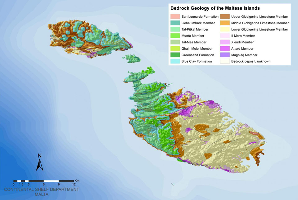

An updated geological map of the Maltese Islands was published last week by Malta’s Continental Shelf Department following a contract awarded to BGS in 2021. The new map is the first update for almost 30 years.
BGS has been surveying the Maltese Islands over the last two years, conducting several field surveys between 2021 and 2022. The new geological map is the first update since 1993 and, at a scale of 1:10 000, is over twice the resolution of its predecessor.
The map is available free of charge through the Continental Shelf Department website. Users can navigate the interactive map through seven different themes, or layers, that define the island’s geological landscape. A GIS version of the new map is also available to download in shapefile format.

Working with the Continental Shelf Department in Malta on an updated geological map of Malta has been a wonderful opportunity for BGS to use its longstanding experience and expertise in surveying and mapping. We hope the updated dataset will be of great benefit to those with an interest in the geology of Malta over the coming years.
Dr David Schofield, director of BGS National and International Geoscience.
The resurveying of the Maltese Islands at a scale of 1:10 000 by BGS represents a significant contribution to the geological mapping of the Maltese Islands. Working with the BGS team over the past two years has been a positive experience with fruitful discussions and exchanges of information leading to a more detailed interpretation of the geology of the Maltese Islands.
Albert Caruana, director general, Continental Shelf Department, Malta.
Relative topics
Related news

Updated national 3D model will determine the depth to the solid bedrock beneath our feet
13/07/2026
The BGS Superficial Deposit Thickness Model now includes an elevation model of geological rockhead for the first time, providing important data for civil engineers, geoscientists and environmental scientists.

UK’s world-class research organisations launch new collective
10/07/2026
The launch of the National Research Organisations Group, brings together more than 100 leaders from government, research, industry and funding organisations, providing an authorativive voice on science, research policy and long-term investment.

Cheshire Geoenergy Observatory releases key geological datasets for UK thermal energy storage scheme design
09/07/2026
A new report and data packs from BGS will provide a unique resource for scientists working on the geology and hydrogeology of the Sherwood Sandstone Formation, an important aquifer and reservoir rock.

New geological mapping underway to help manage flooding along the River Tweed
08/07/2026
Scientists are surveying the Tweed catchment for the first time in over 100 years to enhance understanding of localised groundwater and improve flood forecasting.

Geological research in North Sea helping to safeguard subsea cables
06/07/2026
Subsea power and telecommunications cables are critical to the UK’s energy infrastructure and global connectivity, yet they remain vulnerable to damage from ship anchors, fishing activity and natural hazards.

UK Critical Minerals Intelligence Centre makes recommendations for the next UK criticality assessment
01/07/2026
CMIC has outlined the enhancements made to the next assessment update to ensure it is better tailored to the structure of the UK economy.

From archive to discovery: historical mineral reports support gold exploration in Scotland
25/06/2026
Digitised geological records show potential to unlock untapped mineral resources in Ardlochan, Argyllshire.

UK and Philippines scientists investigate natural hydrogen generation processes at atomic scale
22/06/2026
BGS researchers were granted access to use the Diamond Light Source facility in order to study hydrogen in light brighter than the sun.

Shortage of end-of-life materials presents challenge to UK critical minerals security
17/06/2026
A new report by the UK Critical Minerals Intelligence Centre reveals insufficient end-of-life material stocks present a supply risk over the coming decade, but offer significant long-term potential to meet critical mineral demand through recycling.

UK geothermal catalogue receives update
16/06/2026
BGS releases the second digital version of the UK geothermal catalogue of subsurface temperature and rock thermal conductivity measurements and heat flow calculations.

Scientists make new discovery in the history of the Giant’s Causeway
15/06/2026
New research is changing our scientific understanding of the formation of one of the UK’s most iconic landmarks and has revealed that Northern Ireland’s volcanic past occurred over a much shorter period than previously thought.

Latest research emphasises climate-related subsidence risk to millions of British homes
11/06/2026
New data from BGS highlights the projected future impact of warmer, drier summers and underlines the need for mitigation measures in susceptible regions.