We are researching groundwater extremes, the effects of environmental and climate change on groundwater in the UK and internationally, and what these mean for building a more resilient future for our water resources.
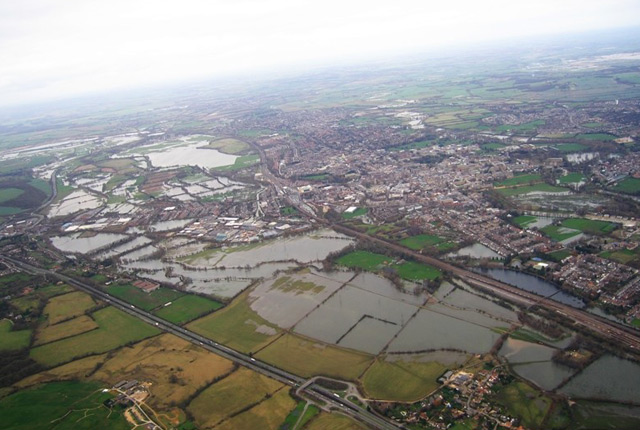

Aerial view of flooding of Oxford in 2007. © NERC/UKRI.
Our research includes quantifying and predicting groundwater extremes (floods and droughts) and improving evidence and understanding of the effects of environmental change on groundwater resources and quality, particularly under the extremes of floods and droughts. The research is focused on the UK and globally in areas of existing or potential future water resource and quality stress, such as sub-Saharan Africa, India and South-east Asia.
We work closely with a wide range of partners both in the UK and internationally to ensure that our research helps them to improve planning and management of water resources, from community to national scale.
Groundwater extremes
Groundwater is affected by extremes in the weather. Periods of abnormally high rainfall can result in groundwater flooding of basements and the emergence of groundwater at the ground surface, causing damage to property and infrastructure.
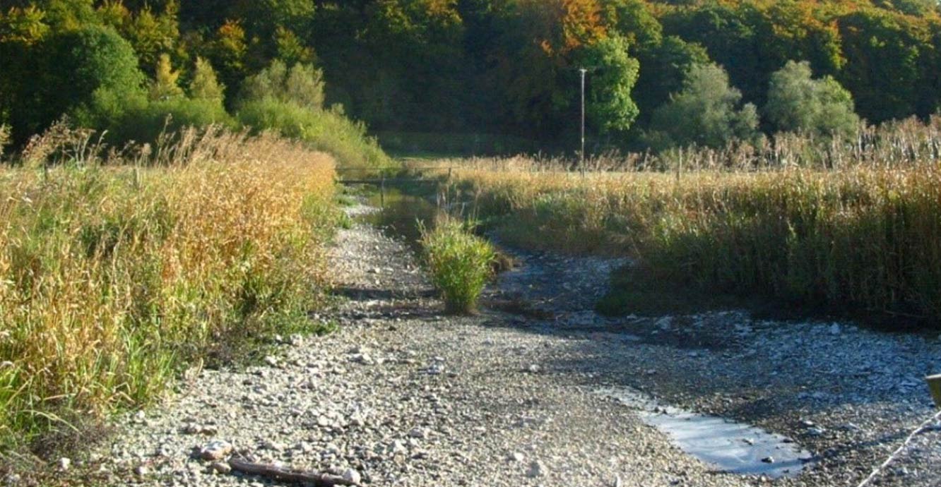
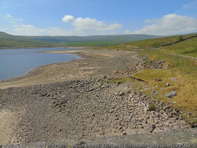
The dry river bed of the River Till, Wiltshire, following a prolonged dry period. © BGS/UKRI.
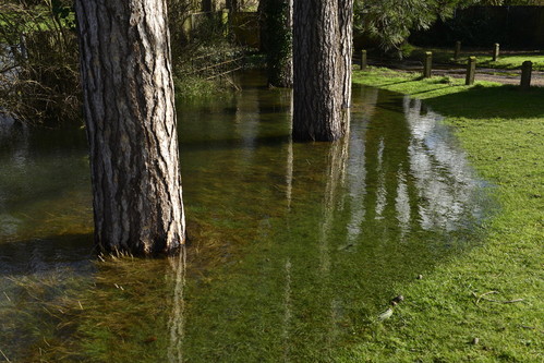
Groundwater flooding in Oxfordshire, 2014. © NERC/UKRI.
Conversely, groundwater levels fall during prolonged periods of dry weather. There is less flow of groundwater to surface streams and wetlands and less groundwater is available for abstraction for use in public supply, for farmers for irrigation, and for industry.
In parts of sub-Saharan Africa, groundwater droughts in extreme cases can lead to failure of crops and loss of access to drinking water.
Groundwater flooding is defined here as the emergence of groundwater at the ground surface away from perennial river channels, or the rising of groundwater into artificial ground, under conditions where the ‘normal’ ranges of groundwater level and groundwater flow are exceeded. Groundwater flooding events are relatively long compared with fluvial (river) flooding.
The effects of groundwater flooding can occur before water levels reach the ground surface, when there is flooding of building basements and buried services or other assets below ground level. Groundwater levels that rise above ground have the potential to reach low-lying areas protected from fluvial flooding.
Exceptionally large flows from perennial springs or large flows from intermittent or dormant springs, which also come under the above definition of groundwater flooding, can cause both localised flooding in the vicinity of the springs and down gradient where surface water drainage channels may not be adequate.
Groundwater flood research
Our scientists are at the forefront of research into groundwater flooding. Current and recent initiatives include:
- publication of the first groundwater flooding susceptibility mapping for the UK
- analytical tools to understand groundwater flooding timing and distribution
- detailed, process-based studies of controls on groundwater flooding and the interaction of natural and built environments with groundwater flooding, e.g. Oxford case study and the LANDWISE natural flood attenuation case study
Groundwater drought is the sustained and extensive occurrence of below-average availability of groundwater. Aquifers in the UK are usually replenished with water during the winter months, so groundwater droughts may develop if there is reduced rainfall over one or successive winters.
Groundwater droughts are marked by lower than average water levels in aquifers, borehole and wells, and by reduced flows to groundwater-fed rivers and wetlands. They can be made worse by high demand for water during unusually hot or particularly dry summers.
We are working to better understand how groundwater droughts occur and the effects they have on humans and the environment.
In developing countries, where communities are particularly reliant on groundwater, groundwater droughts can cost people their livelihoods and even their lives.
Groundwater drought research
We have been researching groundwater drought in the UK and internationally for decades. Or recent and current work is focused on a number of themes:
- We are reconstructing groundwater droughts in the UK since the 1890s, to understand them and provide a historic perspective for assessment and modelling for future droughts.
- We undertake research into how much groundwater is stored in the UK’s main aquifer, the Chalk, and how this varies under drought.
- We are leading the European Groundwater Drought Initiative (GDI), a collaborative project with the University of Birmingham, to develop methods to model groundwater drought status across Europe, to investigate the effects of groundwater drought on the environment and society across Europe, and to build a research community to grow our understanding of the phenomenon of groundwater drought. We are actively seeking partners to contribute to the GDI.
- Through a series of DFID- and NERC-funded projects, we are working with a wide range of partners to understand how groundwater droughts in Africa affect the livelihoods of people who are dependent on groundwater. In particular, our work has highlighted the importance of the links between availability, access and demand for groundwater during droughts.
Groundwater and environmental and climate change
Environmental change and climate change form the context for most of our groundwater research both in the UK and internationally. Here we take ‘environmental change’ to mean decadal and longer-term natural or anthropogenic changes in the environment, such as changes in land cover and land use, in soils and wider catchment characteristics. ‘Climate change’ is taken to mean changes on a similar timescale in the climate, such as changes in temperature, precipitation, and extreme weather events.
We are actively investigating a number of specific topics related to environmental change and climate change, including:
- investigating the effect of warming on groundwater droughts in the UK over the last 100 years
- modelling potential changes in groundwater recharge across the UK to 2100
- modelling future climate change effects on groundwater resources in the UK using UKCP18 scenarios (Future Flows 2 case study)
- assessing resilience of groundwater in Africa to environmental change
We undertook the Future Flows project, carrying out a consistent assessment of the effect of climate change on river flows and groundwater levels across England, Wales and Scotland using the UKCP09 probabilistic climate projections from the Met Office Hadley Centre.
Now, along with UKCEH and HR Wallingford, we are extending this study to use the latest UKCP18 probabilistic climate projections from the Met Office Hadley Centre to develop a prototype climate service that will enhance the resilience of the UK water sector to drought events.
Simulated and observed historical groundwater-level time series are being compared using the non-parametric standardised groundwater level index (SGI). The SGI was developed at the BGS as a means of transforming groundwater-level time series into an intuitive, quantitative metric to characterise the duration, magnitude and intensity of groundwater drought.
The SGI is being used to interrogate the model’s ability to capture these different characteristics over historical drought periods in the observation data at each borehole.
Contact
If you want to discover more then please contact Alan Macdonald.
Related news
UK Minerals Yearbook 2025 now available
21/04/2026
The annual publication provides essential information about the production, consumption and trade of UK minerals up to 2025.

UK scientists unite for seabed mapping survey of the UK’s south-west coastline
15/04/2026
BGS geologists join research voyage, gathering crucial geological data to support offshore energy and infrastructure projects.

Isotopes and science: my student placement at BGS
08/04/2026
Industrial placements at BGS for undergraduate students give real-life experience of working in laboratories and learning different analytical techniques.

Updated geological assessment of the Southern North Sea set to underpin future offshore infrastructure development
25/03/2026
The first regional assessment for 30 years will support offshore marine and subsurface planning for the UK’s low-carbon energy infrastructure, including the 2030 target of 45 to 50 GW generated through offshore wind.

New research could help provide a more reliable water supply for millions in rural Africa
24/03/2026
A new BGS-led study has revealed crucial insights into the longstanding challenges affecting the reliability and performance of rural water supply infrastructure in sub-Saharan Africa.

UK Critical Minerals Intelligence Centre 2026 showcase
Event on 31/03/2026
A special live webinar with the team from the Critical Minerals Intelligence Centre showcasing the latest research from 2026 on copper, the future of digital, and what’s next for the criticality assessment. A recording of the event is now available.

PhD adventures in Copenhagen, Denmark: revealing past recovery processes of tropical forest systems through ancient environmental DNA
12/03/2026
PhD student Chris Bengt visited the University of Copenhagen to carry out very delicate extraction of aeDNA from lake-sediment cores, in the hopes of unlocking the secrets of past volcanic eruptions.

Call for new members and Chair to join the NERC facilities steering committees
25/02/2026
New members are needed to join the committees over the next four years.

Your views wanted: developing a geothermal energy subsurface data portfolio
24/02/2026
BGS is aiming to support the growth of the sector by providing the best-available, location-specific geothermal and ground source heat information as an accessible product or service.

Map of BGS BritPits showing the distribution of worked mineral commodities across the country
18/02/2026
BGS’s data scientists have generated a summary map of the most commonly extracted mineral commodities by local authority area, demonstrating the diverse nature of British mineral resources.
You may also be interested in
Groundwater resources
Groundwater provides invaluable freshwater for public and private supply, agriculture, industry and recreation across the UK and globally.
Groundwater modelling
Our modelling research focuses on the development and application of models to improve our understanding of hydrological and groundwater processes

Groundwater challenges in India and Pakistan
We are reconstructing a century of groundwater level records in order to understand the long-term behaviour of groundwater in north-west India and Punjab in Eastern Pakistan.
Philippine groundwater outlook
The PhiGO project seeks to undertake assessments of population and climate change impacts on regional groundwater resources and translate these into usable forecasts of flood and drought risk.