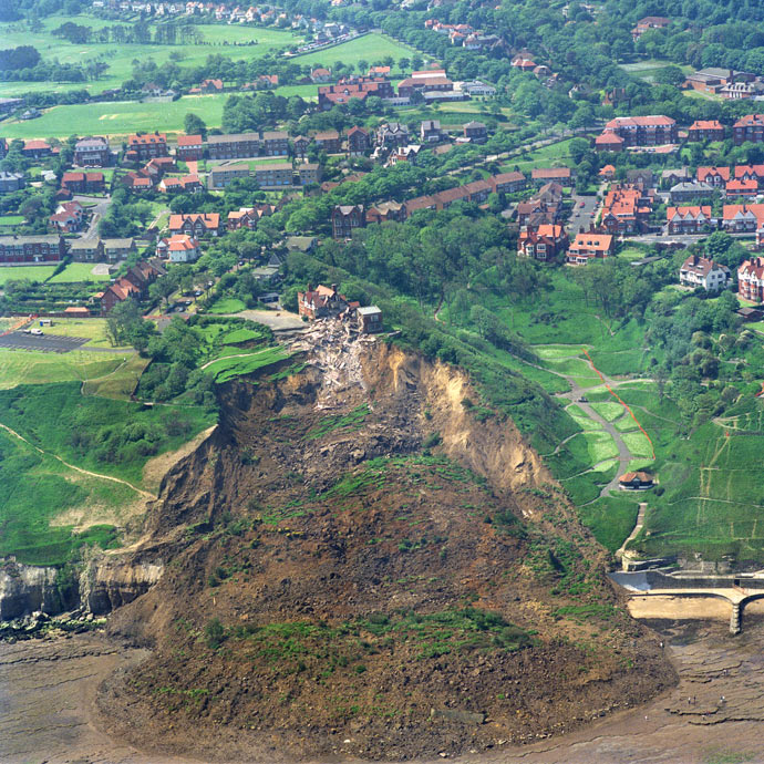

A good example of a rotational landslide is the Holbeck Hall landslide, in Scarborough North Yorkshire, England. The 1 million tonnes of cliff failed as a rotational landslide over a couple of days in June 1993 and destroyed the Hotel at the top of the cliff. The rotated blocks can be seen as grass covered ‘benches’ in the photograph. BGS ©UKRI. All rights reserved.
BGS GeoSure: landslides
- 1:50 000
- Great Britain
- Premium
The potential for landsliding (slope instability) to be a hazard has been assessed using 1:50 000 scale digital maps of superficial and bedrock deposits. These have been combined with information from the BGS National Landslide Database and scientific and engineering reports.
Supporting documents:
Key information
- Scale:
- 1:50 000
- Coverage:
- Great Britain
- Availability:
- Premium
- Price:
£0.35 per km2. Subject to number of users, licence fee and data preparation fee.
- Format:
- GIS polygon data (ESRI, MapInfo, others available by request)
- Uses:
- Local-level use
- Themes:
- Engineering geology, Hazards
Landslides occur ultimately due to the effect of gravity, although other factors can all contribute to the overall stability of a slope, such as:
- geology
- topography
- weathering
- drainage
- construction
Landslides are commonly divided into four categories: falls, topples, slides or flows. Landslides rarely comprise a single type of movement but are often the result of a combination of several types.
Whilst we currently have over 17 000 landslides in the National Landslide Database, many of these are ancient and occurred under different climatic conditions to those of the present day (e.g. in the Pleistocene). If left undisturbed, these ancient mass-movement deposits may remain stable for many years. However, poorly planned development can sometimes reactivate ancient slides.
Downslope movement of materials through landsliding may damage buildings or infrastructure through loss of support or due to direct impact. Common causes of damage due to landslides relate to:
- removal of ground that is supporting a property
- stretching or compression of a building as the ground moves
- material falling onto the property from above
- material flowing into the property from upslope
The potential for landsliding (slope instability) to be a hazard has been assessed using 1:50 000 scale digital maps of superficial and bedrock deposits. These have been combined with information from the National Landslide Database and scientific and engineering reports.
The detailed digital data illustrated in the map is available as attributed vector polygons, as raster grids and in spreadsheet format.
More information about our landslide data products
We currently have three datasets providing information on landslides in Great Britain. These products differ in both their collection method and their intended use.
National Landslide Database
The BGS National Landslide Database currently documents over 17 000 landslides across Great Britain. The database was an inherited dataset, based on a search of secondary sources conducted for the Department of the Environment (DoE) in the 1980s and 1990s, and we have continued to populate this database since the foundation of the DoE dataset.
The database provides a detailed record of landslide events across Great Britain. It contains more than 35 fields that can be attributed with information on the type of landslide, age and causes.
BGS Geology mass-movement layer
The BGS Geology mass-movement layer displays mapped landslides that have been recorded by field geologists. The mass movement layer does not distinguish between different types of failures; it is purely an outline of the landslide deposit.
BGS GeoSure
BGS GeoSure is a national dataset that assesses the potential for ground movement and subsidence across Great Britain. It contains six layers, one of which is for landslides.
BGS GeoSure takes into account the local geology and slope of an area along with the geotechnical and structural characteristics of a geological formation. These conditioning factors are combined within GIS and the result is a susceptibility map of the UK. The BGS GeoSure assessment does not show risk or seek to determine the temporal distribution of landsliding.
You may also be interested in


BGS GeoSure
The BGS GeoSure datasets identify areas of potential hazard and, therefore, potential natural ground movement, in Great Britain.
Landslides: property hazard information
A landslide is the outward and downward movement of rock or soil on a slope. Get specialist advice from a suitably qualified expert.
BGS GeoSure: debris flow susceptibility model
The Debris Flow landslide layer provides information on the potential of the ground, at a given location, to form a debris flow. It is based on a combination of digital geological, hydrogeological and topographic data.