Uncovering secrets of the Mariana Trench
Scientists have discovered that the true extent of the deepest parts of our oceans may be far larger than they previously thought.
31/03/2021 By BGS Press

The deepest parts of our oceans, the region between 6000 and 11 0000 m depth, is known as the hadal zone, and it represents some of the most active and diverse marine habitat on Earth.
Many studies of the hadal zone focus on the conspicuous, gigantic trenches formed by shifting tectonic plates, known as subduction zones. Each of these trenches was thought to represent isolated environments, separated from each other by areas of much shallower water depths.
For decades, researchers studying the hadal zone have had to cope with the technical challenges of working at such great depth. This means understanding of these traditionally difficult to study regions has lagged behind the overlying, shallower water ecosystems. New technologies are changing this imbalance, and there are now more opportunities to explore and study the planet’s most extreme environment; the hadal zone included.
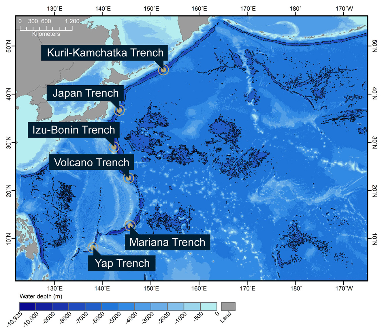
Figure 1: Hadal zones of the Northwest Pacific Ocean. Bathymetry data were obtained from the Global Multi-Resolution Topography Synthesis (Ryan et al. 2009) – click to expand
Understanding more about these deep oceans — some of the most remote and inaccessible habitats on Earth — is crucial for the regulation of global climate and for our understanding of biogeochemical cycles. They provide insights into hazards from submarine landslides and large earthquakes, and will provide invaluable baseline data as human exploration for raw materials ventures into ever deeper waters.
In a recently published study, ‘Hadal zones of the North-west Pacific Ocean‘, led by Newcastle University in collaboration with BGS, scientists attempted to evaluate the true extent of the deepest marine ecosystem by focusing on the North-west Pacific Ocean.
A number of large, subduction trenches are located here, including the deepest point on Earth (Challenger Deep) in the Mariana Trench, a crescent-shaped, 2550 km-long subduction zone that includes the Volcano Trench. At 10 925 m deep, it would immerse Mount Everest with still more water above it and could house 34 Eiffel Towers stacked on top of each other.
Whilst subduction trenches, like those that make up the Pacific ‘Ring of Fire’, are obvious hadal ecosystems, this study explored other geological features such as fracture zones and broad ocean basins. These features, although numerous, are less prominent and are often overlooked.
By evaluating the frequency and distribution of these lesser-known smaller features, the researchers conclude that, in the North-west Pacific, the total hadal area is four times larger than that of trenches alone — roughly equivalent to the size of Alaska, Texas and Montana combined.
In fact, it makes up a staggering 2 793 011 km2; an area considerably larger than the 686 114 km2 accounted for by subduction trenches alone.
Having previously thought the Mariana Trench to be one continuous hadal habitat, the scientists discovered it is in fact five isolated areas, with the most northern being what Russian scientists used to call the Volcano Trench.
The study went on to identify that there are no physical partitions either north or south of the Japan Trench to isolate it from the neighbouring Kuril-Kamchatka or Izu-Bonin trenches, and so it can be concluded that it forms one continuous hadal habitat.

The Mariana-Volcano chain of trenches is more complex than expected. This study proves that there are actually four topographic highs that partition the hadal areas of this subduction zone within what has previously been considered by some to be a single feature.
From a habitat perspective, it means there are five physically isolated hadal habitats making up the Mariana-Volcano complex, which means that the genetic flow between hadal populations of species endemic to these extreme depths will be limited.
This means that hadal depths represent a diversity of species, each potentially carrying hidden secrets that will be important for us to discover and learn from.
Heather Stewart, BGS Marine Geologist and co-author of the study.
The study also revealed that the Yap Trench actually comprises two separate hadal areas.
However, the Izu-Bonin, Japan and Kuril-Kamchatka trenches lack a biologically significant shallow-water divide. These three trenches seem to represent one continuous hadal corridor.
Aside from advancing geological understanding, scientists are particularly interested in these findings from a biological perspective. They are especially keen to understand whether geographically isolated populations may have reduced levels of gene flow between them, causing them to diverge morphologically.
By studying the geomorphology, or shape, of the sea floor, we have revealed which trenches form continuous hadal habitats and which are completely isolated from each other. When you include the previously overlooked hadal areas located away from these subduction zones, the total hadal ecosystem is potentially massive.
Heather Stewart.
In the most recent studies, two main organisms have been used to study hadal endemism: amphipods and fishes.
Amphipods are typically collected consistently in large numbers using baited traps whilst fish are more often observed on baited cameras.
Current theories suggest that most amphipods form isolated populations cannot readily cross abyssal partitions.
With a few rare exceptions, this is also believed to be the case for dominant fish species sampled from depths below 6000 m.
This would explain why some trenches are host to species endemic to that area and why we sometimes see populations evolve to become distinct species between neighbouring trenches, something which is more pronounced with increasing distance between trenches.
These studies highlight that, whilst non-subduction features are an overlooked minor fraction of the total hadal area, they are essential to our understanding of the ecological and evolutionary dynamics across the hadal zone.
Alan Jamieson, marine biologist at Newcastle University and lead author of the study.
One thing our scientists know for certain is that their continued efforts to study seabed geomorphology is crucial to understanding the connectivity between hadal zones.
And we should continue to explore the mysteries of these hadal depths, because our relationship with even the deepest reaches of our maritime environment underpins life on earth.
Media Contact:
Hannah Pole, British Geological Survey Press Office
hapo@bgs.ac.uk | 07565 297 132
Available for interview – (inc. phone or Zoom)
Alan J Jamieson – Newcastle University
Heather Stewart – British Geological Survey
Notes to Editors:
Link to full study, Hadal zones of the Northwest Pacific Ocean: https://www.sciencedirect.com/science/article/pii/S0079661120302123?via%3Dihub
Further studies
- Amphipods from the Wallaby-Zenith Fracture Zone, Indian Ocean: new genus and two new species identified by integrative taxonomy: https://www.tandfonline.com/doi/full/10.1080/14772000.2020.1729891
Jamieson and Stewart collaborate with an international team of experts led by Newcastle University to examine the ecology of the hadal zones in the Wallaby-Zenith Fracture Zone, a complex structure off Western Australia in the Indian Ocean.
Using baited landers, they assessed the amphipod distribution and community structure of lesser studied non-subduction fracture zones, troughs and basins and compared it to more prominent hadal subduction zones.
Eleven species were identified and the community composition was found to change gradually from abyssal to hadal depths, which contrasts with subduction trenches.
Such data indicates that some amphipods have far broader distributions than previously understood, with some species present in both hadal subduction trenches and non-subduction fracture zones and basins.
Non-subduction hadal environments contain characteristically hadal amphipod species but their ecology differs from subduction trenches. Future hadal research must focus on extending our sampling beyond subduction trenches to non-subduction habitats.
- Hadal trenches are dynamic hotspots for early diagenesis in the deep sea: https://www.nature.com/articles/s43247-020-00087-2
Jamieson and Stewart collaborate with an international team of experts led by Professor Ronnie Glud from the Center for Hadal Research at the University of Southern Denmark. In this study, the authors suggest deep ocean trenches are more dynamic and diverse biogeochemical environments than previously thought.Media Contact: Argiro Hay Baltzis, Center for Hadal Research at the University of Southern Denmark: ahb@dg.dk | +4527132764
British Geological Survey
The British Geological Survey (BGS) is a world leading applied geoscience research centre that is part of UK Research and Innovation (UKRI) and affiliated to the Natural Environment Research Council (NERC). BGS core science provides objective and authoritative geoscientific data, information and knowledge to inform UK Government on the opportunities and challenges of the subsurface. It undertakes national and public good research to understand earth and environmental processes in the UK and globally. BGS works with more than 150 private sector organisations, has close links to 40 universities and sponsors about 100 PhD students each year. See www.bgs.ac.uk.
Relative topics
Related news

New NERC-funded project empowers young people to engage with environmental science
23/07/2026
BGS is part of a new, collaborative project, funded through NERC’s ‘Opening up the environment’ programme, helping the environmental research community become more accessible.

Delving deep into mountains for future water security
16/07/2026
A BGS-led project is using new water-tracing investigation methods, geophysics and modelling to understand how water moves from mountains to the lowlands, helping to improve water security for billions of people.

Updated national 3D model will determine the depth to the solid bedrock beneath our feet
13/07/2026
The BGS Superficial Deposit Thickness Model now includes an elevation model of geological rockhead for the first time, providing important data for civil engineers, geoscientists and environmental scientists.

UK’s world-class research organisations launch new collective
10/07/2026
The launch of the National Research Organisations Group brings together more than 100 science leaders to provide an authorativive voice on science, research policy and long-term investment.

Cheshire Geoenergy Observatory releases key geological datasets for UK thermal energy storage scheme design
09/07/2026
A new report and data packs from BGS will provide a unique resource for scientists working on the geology and hydrogeology of the Sherwood Sandstone Formation, an important aquifer and reservoir rock.

New geological mapping underway to help manage flooding along the River Tweed
08/07/2026
Scientists are surveying the Tweed catchment for the first time in over 100 years to enhance understanding of localised groundwater and improve flood forecasting.

Geological research in North Sea helping to safeguard subsea cables
06/07/2026
Subsea power and telecommunications cables are critical to the UK’s energy infrastructure and global connectivity, yet they remain vulnerable to damage from ship anchors, fishing activity and natural hazards.

UK Critical Minerals Intelligence Centre makes recommendations for the next UK criticality assessment
01/07/2026
CMIC has outlined the enhancements made to the next assessment update to ensure it is better tailored to the structure of the UK economy.

From archive to discovery: historical mineral reports support gold exploration in Scotland
25/06/2026
Digitised geological records show potential to unlock untapped mineral resources in Ardlochan, Argyllshire.

UK and Philippines scientists investigate natural hydrogen generation processes at atomic scale
22/06/2026
BGS researchers were granted access to use the Diamond Light Source facility in order to study hydrogen in light brighter than the sun.

Shortage of end-of-life materials presents challenge to UK critical minerals security
17/06/2026
A new report by the UK Critical Minerals Intelligence Centre reveals insufficient end-of-life material stocks present a supply risk over the coming decade, but offer significant long-term potential to meet critical mineral demand through recycling.

UK geothermal catalogue receives update
16/06/2026
BGS releases the second digital version of the UK geothermal catalogue of subsurface temperature and rock thermal conductivity measurements and heat flow calculations.