Standardised framework provides assessment of carbon dioxide storage site readiness
Geoscientists have developed a practical framework for assessing the degree of ’readiness’ of a prospective carbon dioxide storage site.
28/10/2021 By BGS Press

A practical framework for assessing the degree of ’readiness’ of a prospective carbon dioxide (CO2) storage site, drawing on decades of North Sea basin experience, has been shared in a new paper published by the International Journal of Greenhouse Gas Control.
Geoscientists from the ALIGN-CCUS project have developed a framework of CO2 Storage Readiness Levels (SRLs), which capture the entire picture of technical appraisal, permitting and planning activities for a potential storage site and what must be completed before it can become operational.
The framework is based on the national CO2 storage portfolios of the UK, Norway and the Netherlands, which represent 742 saline formation and hydrocarbon field sites. However, the methodology can be applied to a potential storage site at whatever stage of appraisal anywhere in the world.
The system has allowed a comparison of investment levels and the amount of appraisal time required to achieve a permit-ready North Sea CO2 storage site.
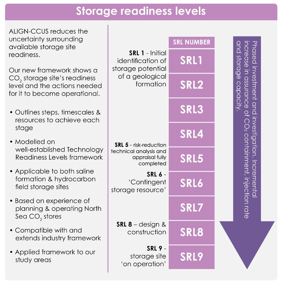
Storage Readiness Levels show the actions that need to be taken for a storage site to be ready for operation. © ALIGN-CCUS/MJD Design.
The researchers took inspiration from Technology Readiness Levels (TRLs), which are used to mark progress in the development of an innovative technology from inception to commercial delivery.

Objectivity is very important for scientific research so we completed our framework first before applying it to the portfolio of prospective and planned sites in each of our countries.
Our system of nine levels benefited greatly from discussion with regulators and offshore industry representatives, which ensured the progression through the SRLs is consistent with the licensing steps required by European legislation. It also ensured that our SRLs are consistent with industry management systems.
Learning from North Sea experience gives realistic estimates of the time and cost needed to bring a site to operational storage and so increase the confidence of investors and operators.
Dr Maxine Akhurst, lead author from the British Geological Survey.
The multidisciplinary ALIGN-CCUS project, which concluded last year, was funded through the EU’s ERA-NET ACT programme to help transform six European industrial regions into economically robust, low-carbon centres by 2025.
Relative topics
Related news

Delving deep into mountains for future water security
16/07/2026
A BGS-led project is using new water-tracing investigation methods, geophysics and modelling to understand how water moves from mountains to the lowlands, helping to improve water security for billions of people.

Updated national 3D model will determine the depth to the solid bedrock beneath our feet
13/07/2026
The BGS Superficial Deposit Thickness Model now includes an elevation model of geological rockhead for the first time, providing important data for civil engineers, geoscientists and environmental scientists.

UK’s world-class research organisations launch new collective
10/07/2026
The launch of the National Research Organisations Group brings together more than 100 science leaders to provide an authorativive voice on science, research policy and long-term investment.

Cheshire Geoenergy Observatory releases key geological datasets for UK thermal energy storage scheme design
09/07/2026
A new report and data packs from BGS will provide a unique resource for scientists working on the geology and hydrogeology of the Sherwood Sandstone Formation, an important aquifer and reservoir rock.

New geological mapping underway to help manage flooding along the River Tweed
08/07/2026
Scientists are surveying the Tweed catchment for the first time in over 100 years to enhance understanding of localised groundwater and improve flood forecasting.

Geological research in North Sea helping to safeguard subsea cables
06/07/2026
Subsea power and telecommunications cables are critical to the UK’s energy infrastructure and global connectivity, yet they remain vulnerable to damage from ship anchors, fishing activity and natural hazards.

UK Critical Minerals Intelligence Centre makes recommendations for the next UK criticality assessment
01/07/2026
CMIC has outlined the enhancements made to the next assessment update to ensure it is better tailored to the structure of the UK economy.

From archive to discovery: historical mineral reports support gold exploration in Scotland
25/06/2026
Digitised geological records show potential to unlock untapped mineral resources in Ardlochan, Argyllshire.

UK and Philippines scientists investigate natural hydrogen generation processes at atomic scale
22/06/2026
BGS researchers were granted access to use the Diamond Light Source facility in order to study hydrogen in light brighter than the sun.

Shortage of end-of-life materials presents challenge to UK critical minerals security
17/06/2026
A new report by the UK Critical Minerals Intelligence Centre reveals insufficient end-of-life material stocks present a supply risk over the coming decade, but offer significant long-term potential to meet critical mineral demand through recycling.

UK geothermal catalogue receives update
16/06/2026
BGS releases the second digital version of the UK geothermal catalogue of subsurface temperature and rock thermal conductivity measurements and heat flow calculations.

Scientists make new discovery in the history of the Giant’s Causeway
15/06/2026
New research is changing our scientific understanding of the formation of one of the UK’s most iconic landmarks and has revealed that Northern Ireland’s volcanic past occurred over a much shorter period than previously thought.