Spaceborne data: an expanding role in disaster response
Alessandro Novellino explains the importance of Earth observation to help facilitate successful emergency responses after natural hazard occurrences.
23/06/2021 By BGS Press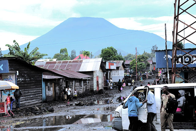

My name is Alessandro and I am a remote sensing geoscientist at BGS. I use satellite data to map, monitor and model geohazards and part of my job consists of working during disaster response activities.
The key to successful emergency response is quick and effective early action. This is only possible if the right information is available in the right place, in the shortest time possible. Because we are now in the ‘Golden Age’ of spaceborne Earth observation (EO), satellite data is providing users with an unprecedented wealth of data1 that is stimulating the growth of processing services2 and novel methodologies3 while also improving our capability in disaster response situations.
I use EO data to identify damaged areas or potential cascading hazards following a disaster, which support civil protection authorities and international humanitarian communities in planning the logistics of relief action. I built most of my experience by leading EO activities for the processing of satellite data needed to reconstruct the evolution of volcanic activity that led to the Anak Krakatau 2018 collapse and tsunami4,5.
Since then, I have become an authorised user of the Disaster Charter. The charter is a worldwide collaboration, by which satellite data are made available for the benefit of disaster management. By combining EO data from different space agencies and commercial provides, the charter allows expertise to be coordinated for rapid response to major disaster situations. Equally importantly, the charter prompts participating space agencies to release satellite data at no cost.
To have an idea of the rapid growth in the use of satellite data from the disaster response community, the charter was activated 11 times in 2000, when the organisation was first established, rising to 55 times in 2020. My most recent work for the charter is related to the Nyiragongo volcano in the Democratic Republic of the Congo. The charter was activated6 less than a day after Nyiragongo’s eruption on 22 May 2021. At least 30 people died and thousands more fled to Rwanda to escape the dangers associated with the eruption, which occurred when fractures opened in the volcano’s side.
Soon after the activation I liaised with international space agencies (the European Space Agency, Japan Aerospace Exploration Agency and Argentina’s space agency CONAE) to coordinate the acquisition of tasked radar data over the volcano, resulting in a total of 18 images over the first two weeks. Differing from optical data, radar sensors can ‘see’ almost completely through clouds and volcanic plumes (Figure 1).
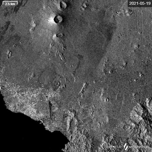
Figure 1 Radar backscattered signal from Sentinel-1 data (VH polarisation, decibel scale) for the 19-5-2021 and 25-5-2021. Data processed through the Sentinel EO-Browser. New lava flows are visible as darker areas on the southern and south-eastern slope of the Nyiragongo volcano.
This gave me a unique opportunity to map the lava flows from space7 and estimate a total lava extent of about 9.4 km2 with around 1100 infrastructure affected (as of the 27 May). Although this is a preliminary analysis that has not yet been validated in the field (Figure 2), this piece of information was key for the BGS volcanology team to work in collaboration with the Goma Volcanological Observatory and assess eruptive volume calculations, vent identification, and probabilistic lava flow hazard assessments.
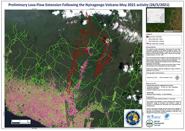
Figure 2 Preliminary lava flow extension following the Nyiragongo volcano eruption as communicated by BGS to the Disaster Charter on 26 May 2020.
This Nyiragongo event shows how international initiatives provide organizations working on the front lines, like BGS, with the opportunity to increase the impact and effectiveness of our science by having quick access to EO data. However, I believe that the next step forward in the uptake of EO for disaster response lies in capacity-building activities, in an effort to help lower- and middle-income countries use and benefit from space-based technologies not just at the response stage but, more importantly, during mitigation and preparedness, key phases to assess a region’s vulnerability and mitigate the risk.
Recently, a number of initiatives (UNOOSA, UNOSAT) are going into this direction and, in addition, NGOs are showing growing interest in space-based geographic information. I look forward to watching the progress.
Relative topics
References
Novellino, A, and Grebby, S. 2020. Special Issue on “Mapping and Monitoring of Geohazards”. Applied Sciences, Vol. 10(13), 4609. DOI: https://doi.org/10.3390/app10134609
Mapping Ground Deformation from Space by Alessandro Novellino (Geoblogy)
Novellino, A, Cesarano, M, Cappelletti, P, Di Martire, D, Di Napoli, M, Ramondini, M, Sowter, A, and Calcaterra, D. 2021. Slow-moving landslide risk assessment combining Machine Learning and InSAR techniques. CATENA, Vol. 203, 105317. DOI: https://doi.org/10.1016/j.catena.2021.105317
Hunt, J E, Tappin, D R, Watt, S F L, Susilohadi, S, Novellino, A, Ebmeier, S K, Cassidy, M, Engwell, S.L., Grilli, S T, Hanif, M, Priyanto, W S, Clare, M A, Abdurrachman, M, and Udrekh, U. 2021. Submarine landslide megablocks show half of Anak Krakatau island failed on December 22nd 2018. Nature Communications, Vol. 12, 2827. Supported through NERC Urgency Grant (NE/T002018/1) and ODA funding (NE/R000069/1). DOI: https://doi.org/10.1038/s41467-021-22610-5
Novellino, A, Engwell, S L, Grebby, S, Day, S, Cassidy, M, Madden-Nadeau, A, Watt, S, Pyle, D, Abdurrachman, M, Edo Marshal Nurshal, M, Tappin, D R, Andri Kurniawan, I, and Hunt, J. 2020. Mapping recent shoreline changes spanning the lateral collapse of Anak Krakatau volcano, Indonesia. Applied Sciences, Vol. 10(2), 536. Supported through NERC Urgency Grant (NE/T002018/1) and ODA funding (NE/R000069/1). DOI: https://doi.org/10.3390/app10020536
Disaster Charter newsletter subscription