New tool provides users with free access to geological models for three major UK cities
A new tool providing free user access to 3D geological models has been added to the GeoIndex.
18/11/2021 By BGS Press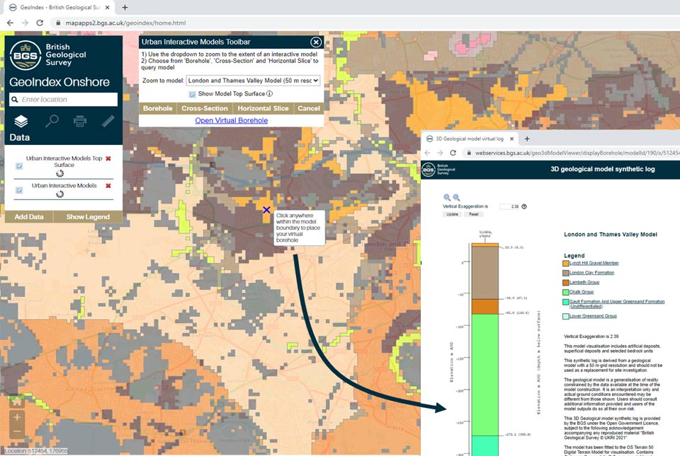

A new urban interactive models tool, providing free user access to geological models for selected UK cities, has been added to BGS’s GeoIndex service.
BGS GeoIndex already provides access to a range of 2D information and data resources through an interactive map viewer, enabling users to navigate to their area of interest, view and query datasets, download reports and clip data, and make enquiries.
The new tool allows users to capture synthetic boreholes, geological cross-sections and slices through 3D models developed by BGS for London, Glasgow and Cardiff, the largest cities in England, Scotland and Wales.
A range of technical, professional and academic users, in particular consultancy for the geotechnical, construction and groundwater sectors, will benefit from the tool, which makes key urban models freely accessible for the first time.
The models provide regional geological understanding (50 m resolution) designed to help users develop conceptual ground models and plan ground investigations.
Users can query the geological model to obtain a range of visualisations of geological conditions beneath each of the cities. The views can also be downloaded as a standard format PDF.

3D urban geology on the BGS GeoIndex. BGS © UKRI.
Each of the geological models was constructed through the analysis of thousands of borehole records and integration with geological map data, informed by extensive literature review. In addition to the virtual borehole and section functions, a new slice function is being trialled for displaying geological units at specified depths.
Katie Whitbread, who leads the national geological modelling programme at the BGS, said the tool helps inform the development of conceptual ground models for construction and groundwater management, as well as supporting early-stage planning.

Urban geological models encapsulate a huge amount of geological data and knowledge to provide comprehensive 3D information on the variability of the rocks and sediments underlying our cities. Understanding this variability is critical for de-risking decision making and investment in a range of applications from construction to the management of surface and groundwater.
Conceptual ground models are a key component of early planning and desktop studies, helping to identify potential risks, develop hypotheses around ground conditions, optimise the design of targeted investigations and allow communication of the geological conditions to different stakeholders.
The urban interactive model tool adds value to the initial stages of this development process, providing accessible regional geological understanding for key UK cities, derived directly from three-dimensional geological characterisation of the upper few 100 m of the ground.
Katie Whitbread, project manager, BGS National Geological Model.
Through the tool, users can link to other BGS resources including the lexicon, model metadata reports and relevant research reports for the selected cities, and access wider 2D and 3D data services.
The underlying model data, along with a range of other BGS LithoFrame models, can be licensed through BGS Data Services, who can also arrange academic licences. BGS also provides bespoke modelling services and commissioned research for users requiring access to more detailed information. Users are encouraged to provide feedback by email to BGS Enquiries and are invited to get in touch if they are interested in being part of a user forum to help inform the design and development of new features and functions.
Whilst the tool is not intended to provide a substitute for detailed site investigations and we recognise these evaluations require additional information, the geological model provides a baseline dataset and regional context that, crucially, can inform early decision making, particularly at the desk study stage.
We are committed to working closely with potential users and stakeholders to develop the model and explore how BGS can advance its 3D geology services to help support planning and resource assessments.
Working with our stakeholders, we would like to explore future development of the tool such as increasing the coverage of UK urban areas, adding geotechnical and hydrogeological information and providing additional digital output formats so that GeoIndex continues to provide subsurface knowledge where it is needed most.
Katie Whitbread, project manager, BGS National Geological Model.
The new tool can be accessed by opening the onshore GeoIndex online and navigating to the new ‘3D models’ layer, under the data list.
Relative topics
Related news

Delving deep into mountains for future water security
16/07/2026
A BGS-led project is using new water-tracing investigation methods, geophysics and modelling to understand how water moves from mountains to the lowlands, helping to improve water security for billions of people.

Updated national 3D model will determine the depth to the solid bedrock beneath our feet
13/07/2026
The BGS Superficial Deposit Thickness Model now includes an elevation model of geological rockhead for the first time, providing important data for civil engineers, geoscientists and environmental scientists.

UK’s world-class research organisations launch new collective
10/07/2026
The launch of the National Research Organisations Group brings together more than 100 science leaders to provide an authorativive voice on science, research policy and long-term investment.

Cheshire Geoenergy Observatory releases key geological datasets for UK thermal energy storage scheme design
09/07/2026
A new report and data packs from BGS will provide a unique resource for scientists working on the geology and hydrogeology of the Sherwood Sandstone Formation, an important aquifer and reservoir rock.

New geological mapping underway to help manage flooding along the River Tweed
08/07/2026
Scientists are surveying the Tweed catchment for the first time in over 100 years to enhance understanding of localised groundwater and improve flood forecasting.

Geological research in North Sea helping to safeguard subsea cables
06/07/2026
Subsea power and telecommunications cables are critical to the UK’s energy infrastructure and global connectivity, yet they remain vulnerable to damage from ship anchors, fishing activity and natural hazards.

UK Critical Minerals Intelligence Centre makes recommendations for the next UK criticality assessment
01/07/2026
CMIC has outlined the enhancements made to the next assessment update to ensure it is better tailored to the structure of the UK economy.

From archive to discovery: historical mineral reports support gold exploration in Scotland
25/06/2026
Digitised geological records show potential to unlock untapped mineral resources in Ardlochan, Argyllshire.

UK and Philippines scientists investigate natural hydrogen generation processes at atomic scale
22/06/2026
BGS researchers were granted access to use the Diamond Light Source facility in order to study hydrogen in light brighter than the sun.

Shortage of end-of-life materials presents challenge to UK critical minerals security
17/06/2026
A new report by the UK Critical Minerals Intelligence Centre reveals insufficient end-of-life material stocks present a supply risk over the coming decade, but offer significant long-term potential to meet critical mineral demand through recycling.

UK geothermal catalogue receives update
16/06/2026
BGS releases the second digital version of the UK geothermal catalogue of subsurface temperature and rock thermal conductivity measurements and heat flow calculations.

Scientists make new discovery in the history of the Giant’s Causeway
15/06/2026
New research is changing our scientific understanding of the formation of one of the UK’s most iconic landmarks and has revealed that Northern Ireland’s volcanic past occurred over a much shorter period than previously thought.