New method offers rapid monitoring of contamination in drinking water
Scientists have developed an innovative new method to monitor the risk of contamination in drinking water with immediate results, enabling global communities to respond rapidly and help reduce exposure to deadly diarrhoeal diseases.
20/10/2021 By BGS Press

A new study, published this week in Water Research and led by James Sorensen of the British Geological Survey (BGS), shows how a technique exploiting the fluorescent properties of microbiological materials in water provides an easy-to-use method that is a more resilient indicator of the risk of faecal contamination to water supplies than thermotolerant coliform bacteria, known as TTCs, which have been the most common standard approach to water testing for decades.
The research, conducted by a collaborative team from the BGS, Makerere University in Uganda and UCL, examined changes in water quality over a 14-month period from 40 sources supplied by groundwater in the rapidly expanding town of Lukaya in southern Uganda.
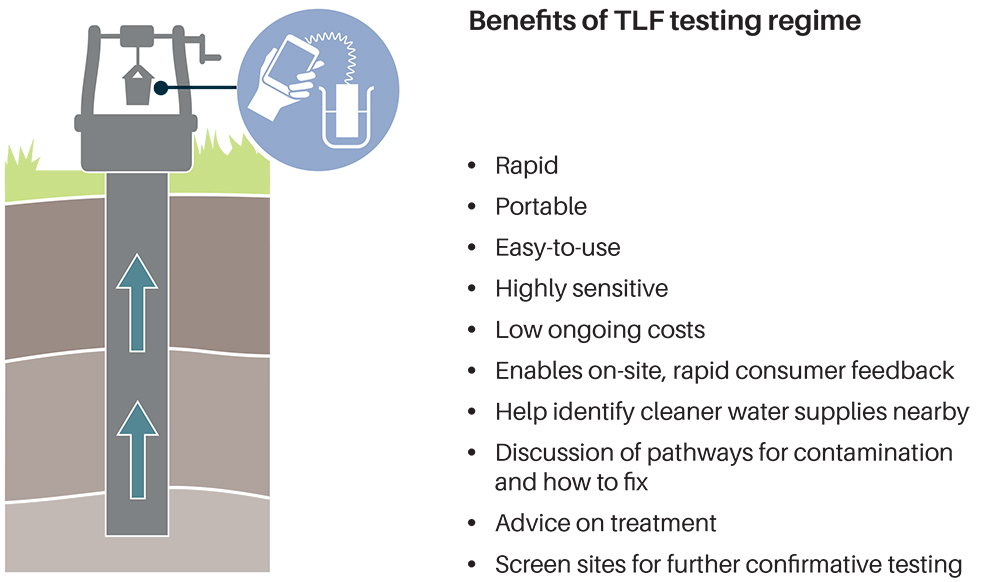
TLF testing offers a rapid, portable, easy-to-use method of assessing the quality of drinking water supplies. Working with local communities, testing personnel can discuss test results, help identify better local water supplies or give advice on water treatment. Testing personnel can also explain how supplies could have become contaminated, how to mitigate further contamination, and take biological samples for further investigation of the microbial risk. (BGS © UKRI)
The results show that in situ fluorescence not only provides an instantaneous measure of faecal contamination but that it is also a more reliable measure of the risk of faecal contamination than TTCs.
Drinking water contaminated with human and animal faeces is consumed by at least two billion people worldwide. This pollution is responsible for outbreaks of waterborne diseases that remain common, even in high-income countries.
Standard approaches to test water supplies have long used bacteriological indicators of faecal contamination, most commonly TTCs. This approach requires working with sterile equipment and testing that can take one or two days to return results, due to the necessity of culturing.
The cumbersome nature of these tests limits the frequency of sampling, so contamination can be missed. Even if identified, lags of one or two days before results are returned mean that people may have already been exposed to the faecal contamination.

‘In situ fluorescence spectroscopy provides an instantaneous assessment of faecal contamination allowing rapid feedback to consumers to reduce their exposure to faecally contaminated drinking water. For example, in the UK, online fluorescence could minimise widespread boil alerts currently triggered when contaminated water is circulated and, potentially, consumed by thousands of people before there is any indication of contamination using standard approaches.’
Lead author James Sorensen, BGS
‘The ability to test in situ fluorescence as an indicator of faecal contamination risk in a wide range of environments and conditions has greatly improved both the evidence base for this method of water quality monitoring and our understanding of what fluorescence observed in water means.’
Co-author Prof Richard Taylor, UCL Geography
‘This robust, rapid method of monitoring the risk posed by faecal contamination has enormous implications in Uganda, not only for untreated water sources such as wells and springs, as it enables communities to respond rapidly to contamination events, but also for low-cost, continuous monitoring of piped water supplies.’
Co-author Dr Robinah Kulabako, Makerere University
The research builds upon field studies conducted in a network of urban observatories in Senegal, Kenya and Uganda under the UCL-led AfriWatSan project, supported by The Royal Society and the Foreign, Commonweath & Development Office (FCD0) as well as research in the UK, India and Zambia that was funded by the UK’s Natural Environment Research Council (NERC).
The full paper is published in in Water Research. Further details about the research can be found on the BGS website.
Read more about the UCL Department of Geography and Makerere University.