New 3D model will help guide exploration for rare earth element deposits in alkaline igneous systems
A team of scientists and institutions across Europe have developed a new 3D geological model designed to guide exploration for rare earth elements.
30/06/2022 By BGS Press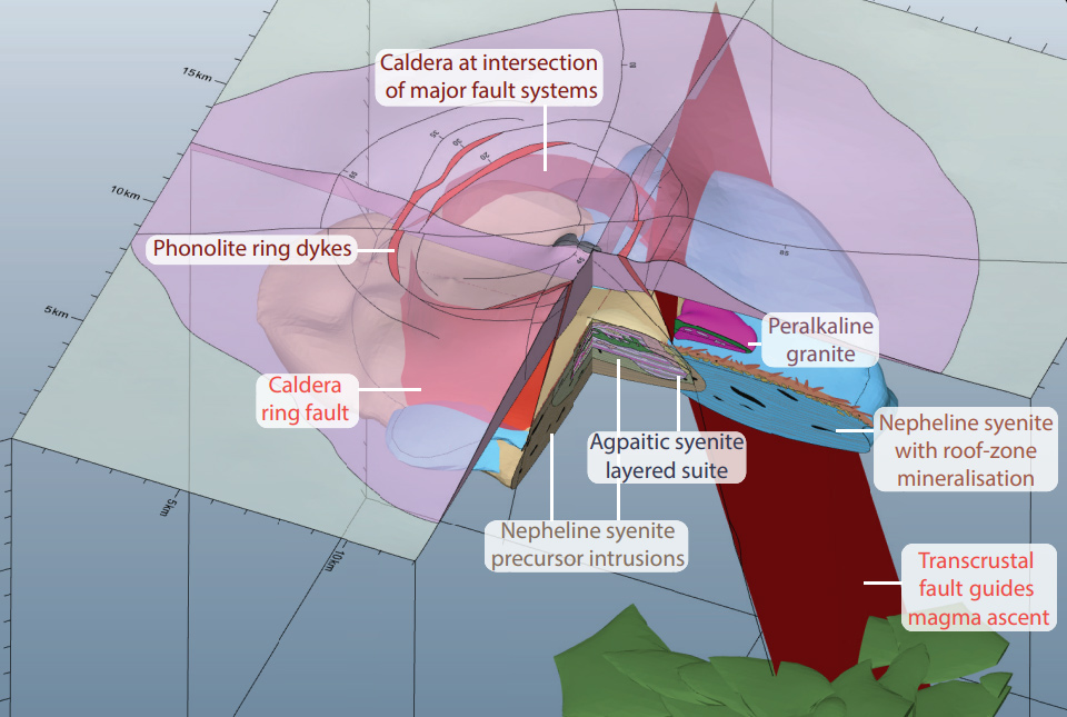

Scientists from BGS and the University of Exeter, alongside a team of institutions across Europe, have developed a new 3D geological model designed to guide exploration for rare earth elements (REE), which are critical for development of renewable energy and transport. The model targets alkaline igneous systems, which host many of the world’s REE deposits.
The development of decarbonised renewable energy and transport infrastructure will require a new balance of minerals, including greater quantities of metals. Increasing demand cannot be met by recycling.
Critical minerals are those with high risk to supply, for example specialist materials produced in only a handful of countries. This includes the rare earth elements, or REE, which is the name given to 17 chemically similar, metallic elements that occur in a wide range of minerals and are mined collectively.
REE are essential raw materials for a wide range of applications, including permanent magnets, metal alloys, ceramics and glass, rechargeable batteries and fibre-optics, amongst others. They are therefore vital for technologies that will support the world’s transition to renewable energy, ranging from wind turbines to electric vehicles, communications networks and more.
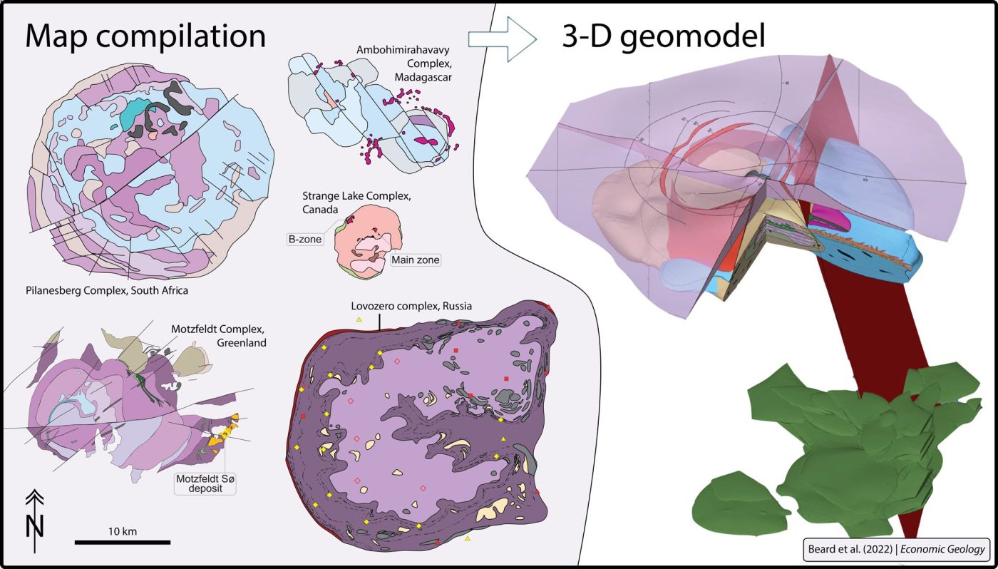
A compilation of maps and geophysical observations was used to construct a 3-D model for alkaline-silicate systems at the district scale (25 km cube). The 3-D model shows the typical location of various critical metal deposits relative to other related rock types and is intended streamline exploration for large and high-grade metal deposits that could be mined to support the green energy transition. Source: Beard et al. (2022) | Economic Geology
Despite this, exploration models for REE are comparatively less well developed than those for major and precious metals such as iron, copper and gold, where most of the mineral exploration industry continues to focus. To address this, a multidisciplinary team of scientists led by economic geologists at BGS have, for the first time, developed a 3D geological model that will help to guide exploration for the REE using both geophysical and geochemical approaches.
Groups of alkaline igneous rocks with a common geological history (alkaline igneous systems) occur at many localities around the world and are common hosts of REE deposits. The new model, which is based on a compilation of maps, geophysical and geochemical data, and petrological observations from alkaline igneous systems worldwide, was published in Economic Geology. It was developed as part of HiTech AlkCarb, a European Union Horizon 2020 project led by the University of Exeter, with 40 participants spread across geological surveys, companies and universities throughout Europe.

Decarbonisation of energy and transport is driving increased demand for many metals, including critical raw materials, such as the rare earth elements.
Because historical demand for the REEs has been low, their supply chains are dominated by a handful of countries who invested early. Our understanding of the geology of REE deposits was largely based on detailed studies of individual occurrences, with a host of complex local nomenclature — a barrier to exploration, relative to more mature commodities such as copper or gold.
The aim of this work was to generate a multiscale REE exploration guidebook for alkaline-silicate systems, allowing geologists to more efficiently locate prospective regions and REE deposits. This was done by synthesising diverse observations from maps, geophysical models and geochemical indicators to generate a workflow for explorers that is applicable from continental to deposit scale. The publication includes a schematic 3D model for alkaline-silicate systems showing the position of various types of critical mineral deposits.
Dr Charles Beard, University of Cambridge research associate and lead author of the work.
Global demand for critical minerals has experienced unprecedented growth in the 21st century. The majority of the world’s resources of some of these elements, particularly the REE, are found in alkaline igneous systems.
Although REE deposits are present all over the world, mines are mainly limited to China, upon which the EU still primarily depends for imports.
The aim of our work was to produce a model that could guide exploration of alkaline igneous rocks and, importantly, develop our understanding of the 3D structures of these deposits. This is the first time a model has been visualised in this way.
We also recommended geophysical and geochemical approaches for exploration targeting, as well as mineral processing and environmental factors pertinent to the development of mineral resources hosted by alkaline igneous systems.
Dr Kathryn Goodenough, BGS Principal Geologist and co-author of the work.
I am delighted to see this paper published. Charlie has done a great job of harnessing all the expertise in our large European research project for this seminal paper. I am sure it will be the ‘go to’ reference for economic geologists exploring for REE in alkaline rocks as well as for future researchers. We made the 3D model so that geologists new to alkaline rocks can quickly learn the key points to guide the search for REE. The main body of the paper contains a comprehensive, in depth review and discussion of the science.
Prof Frances Wall, professor of applied mineralogy at Camborne School of Mines, University of Exeter, coordinator of the HiTech AlkCarb project and co-author of the work.
Project partners
The project was a collaboration between 40 scientists from universities, companies and geological surveys across Europe.
Funding
This research has received funding from the European Union’s Horizon 2020 research and innovation programme under Grant No. 689909.
Relative topics
Related news

Call for new members and Chair to join the NERC facilities steering committees
25/02/2026
New members are needed to join the committees over the next four years.

Your views wanted – developing a ‘Geothermal energy subsurface data portfolio’
24/02/2026
BGS is aiming to support the growth of the sector by providing the best-available, location-specific geothermal and ground source heat information as an accessible product or service.

Map of BGS BritPits showing the distribution of worked mineral commodities across the country
18/02/2026
BGS’s data scientists have generated a summary map of the most commonly extracted mineral commodities by local authority area, demonstrating the diverse nature of British mineral resources.

Funding awarded to map the stocks and flows of technology metals in everyday electronic devices
12/02/2026
A new BGS project has been awarded Circular Electricals funding from Material Focus to investigate the use of technology metals in everyday electrical items.

New UK/Chile partnership prioritises sustainable practices around critical raw materials
09/02/2026
BGS and Chile’s Servicio Nacional de Geología y Minería have signed a bilateral scientific partnership to support research into critical raw materials and sustainable practices.

Extensive freshened water confirmed beneath the ocean floor off the coast of New England for the first time
09/02/2026
BGS is part of the international team that has discovered the first detailed evidence of long-suspected, hidden, freshwater aquifers.

Funding secured to help mitigate ground risk in UK construction sector
05/02/2026
The BGS Common Ground project has been awarded new funding to help unlock the value of ground investigation data.

Can sandstones under the North Sea unlock the UK’s carbon storage potential?
02/02/2026
For the UK to reach its ambitious target of storing 170 million tonnes of carbon dioxide per year by 2050, it will need to look beyond the current well-studied geographical areas.

Quaternary UK offshore data digitised for the first time
21/01/2026
The offshore wind industry will be boosted by the digitisation of a dataset showing the Quaternary geology at the seabed and the UK’s shallow subsurface.

Suite of ten new soil reference materials released
02/01/2026
BGS has a longstanding track record of producing high-quality reference materials and has released ten new soil reference materials.
Perth and Kinross tops the UK’s earthquake activity charts for 2025
29/12/2025
Seismologists at BGS have published data on the number of seismic events over the past 12 months with over 300 earthquakes recorded.

BGS awarded funding to support Malaysia’s climate resilience plan
17/12/2025
The project, funded by the Foreign, Commonwealth & Development Office, will focus on minimising economic and social impacts from rainfall-induced landslides.