Map of BGS BritPits showing the distribution of worked mineral commodities across the country
BGS’s data scientists have generated a summary map of the most commonly extracted mineral commodities by local authority area, demonstrating the diverse nature of British mineral resources.
18/02/2026 By BGS Press

The BGS BritPits dataset contains more than 264 000 records of onshore mineral workings located in Great Britain, Northern Ireland, the Isle of Man and the Channel Islands. The data includes active, inactive, dormant and ceased sites, as well as a range of mineral operations including mines, quarries and onshore oil and gas fields, together with wharfs and rail depots handling mineral products and industrial processes. Each record describes an onshore mineral working in terms of its name, operational status, geographical location, Mineral Planning Authority (MPA), operator, geology, worked mineral commodity and a range of relevant metadata.
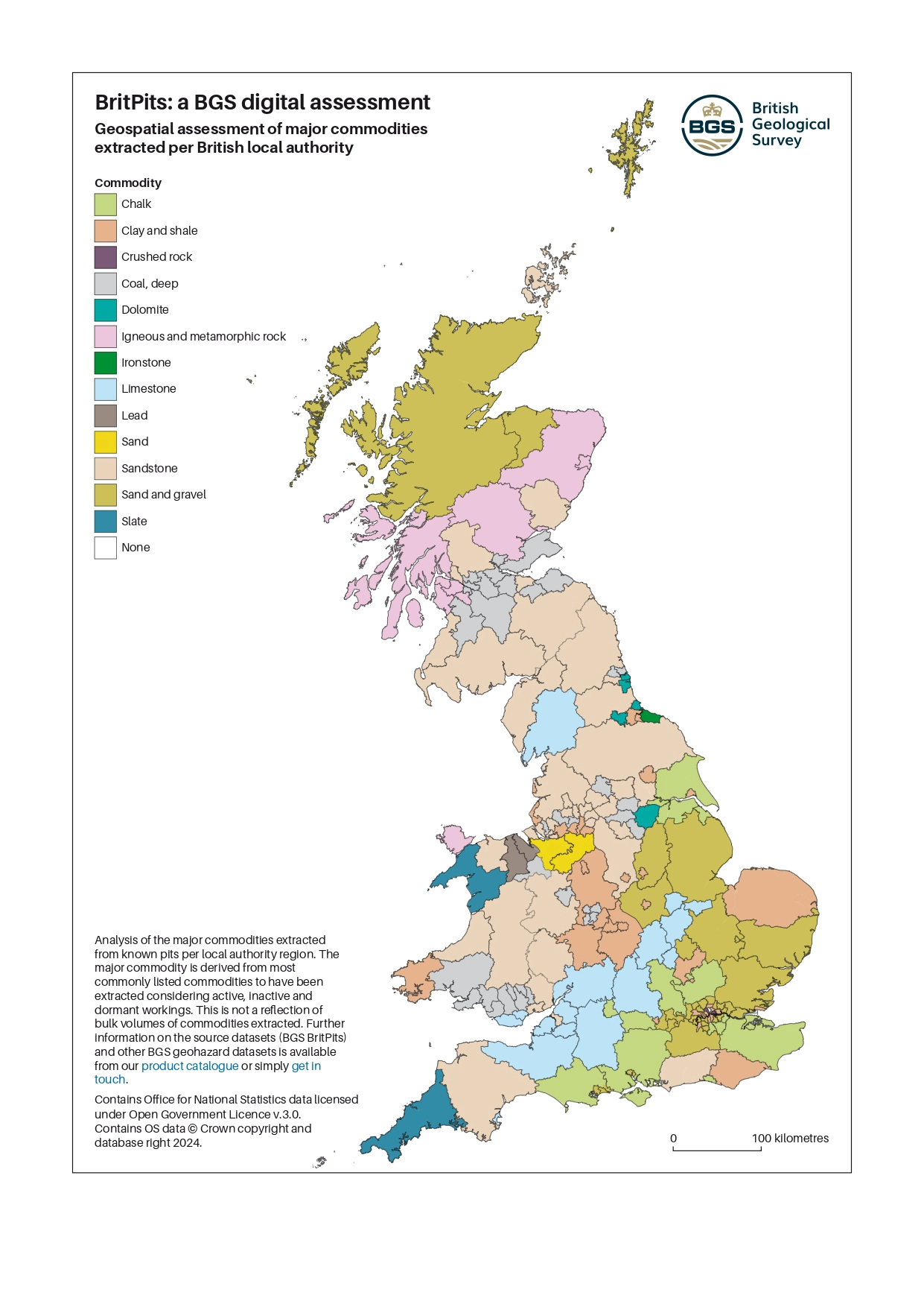
An analysis of commodities extracted from known pits per local authority region. Contains Office for National Statistics data licensed under Open Government Licence v 3.0. Contains OS data © Crown copyright and database right 2024.
Three levels of BGS BritPits data are available. The open-source index is based on the full BritPits dataset but contains index level information only, including the name, status and location of the working. This can be accessed as a Web Map Service (WMS) layer or via the BGS Onshore GeoIndex. The other two levels are available as licensed datasets.
- The open-source index package is available under an Open Government Licence
- The full dataset includes all the entries of the BGS BritPits database, including historic sites; this data is also available for specific Mineral Planning Areas
- A subset of the full dataset that contains only the active, inactive and dormant mines and quarries (over 5200 entries)
These datasets are updated every year. The latest version, released in February 2026, contains 264 549 records, an increase from 262 814 records in the previous version.
This data will be of use to organisations in the public and private sector who have an interest in the location of mineral extraction sites and their possible after-use. For example, the data has been supplied to:
- national and local governments for use in planning and statistical studies
- non-governmental organisations for environmental and conservation planning
- commercial organisations for analysis of resource potential and legacy operations
Relative topics
Related news

Updated geological assessment of the Southern North Sea set to underpin future offshore infrastructure development
25/03/2026
The first regional assessment for 30 years will support offshore marine and subsurface planning for the UK’s low-carbon energy infrastructure, including the 2030 target of 45 to 50 GW generated through offshore wind.
Map of BGS BritPits showing the distribution of worked mineral commodities across the country
18/02/2026
BGS’s data scientists have generated a summary map of the most commonly extracted mineral commodities by local authority area, demonstrating the diverse nature of British mineral resources.

Funding awarded to map the stocks and flows of technology metals in everyday electronic devices
12/02/2026
A new BGS project has been awarded Circular Electricals funding from Material Focus to investigate the use of technology metals in everyday electrical items.

Funding secured to help mitigate ground risk in UK construction sector
05/02/2026
The BGS Common Ground project has been awarded new funding to help unlock the value of ground investigation data.

Can sandstones under the North Sea unlock the UK’s carbon storage potential?
02/02/2026
For the UK to reach its ambitious target of storing 170 million tonnes of carbon dioxide per year by 2050, it will need to look beyond the current well-studied geographical areas.

Quaternary UK offshore data digitised for the first time
21/01/2026
The offshore wind industry will be boosted by the digitisation of a dataset showing the Quaternary geology at the seabed and the UK’s shallow subsurface.

New geological maps of the Yorkshire Wolds to better inform groundwater management and policy decisions
17/12/2025
The new mapping provides crucial data on localised geological issues that may assist in protecting water supplies.

New 3D model to help mitigate groundwater flooding
08/12/2025
BGS has released a 3D geological model of Gateshead to enhance understanding of groundwater and improve the response to flooding.

BGS welcomes publication of the UK Critical Minerals Strategy
23/11/2025
A clear strategic vision for the UK is crucial to secure the country’s long-term critical mineral supply chains and drive forward the Government’s economic growth agenda.

Latest BGS Geology 50K mapping data launched
06/11/2025
Some of our most widely used maps have received a major update, including the 1:50 000-scale map series that now includes enhanced coverage of Great Britain.

World Cities Day: the geological story of our cities
31/10/2025
Understanding the rocks that underlie our towns and cities, the risks they can present and how they influence urban planning and redevelopment.

Extended seabed geology map of the Bristol Channel published
07/10/2025
BGS has released significantly extended high-resolution maps that will support offshore green-energy initiatives in the area.