GeoIndex datasets have been made available as Open Geospatial Consortium (OGC) web map services (WMS). View in compatible software or in portal-style websites that use a map-based interface to connect to WMS.
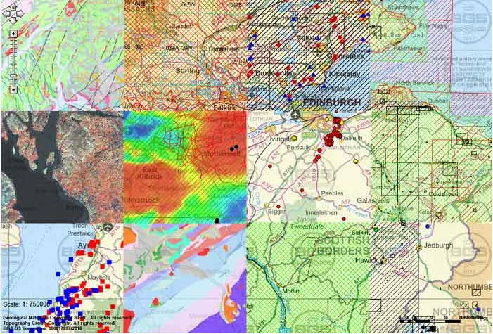

Patchwork of a section of GeoIndex in Scotland showing the different layers you can view. Source: BGS © UKRI – contains Ordnance Survey data © Crown copyright 2020.
These web services allow you to bring the GeoIndex data layers into your own mapping software (GIS systems, etc.) to be viewed and compared alongside your own data and data from other providers.
Service addresses
GeoIndex web services support WMS 1.3.0 and WMS 1.1.1. The addresses you need to connect to the data from the various Geoindex themes are provided.
Enter the addresses below into your WMS client.
Please note occassionally we have to change the address of these services. Please make sure you are using the latest versions. Support cannot be guaranteed for previous versions.
Boreholes
https://map.bgs.ac.uk/arcgis/services/GeoIndex_Onshore/boreholes/MapServer/WmsServer
AGS Boreholes
https://map.bgs.ac.uk/arcgis/services/AGS/AGS_Export/MapServer/WMSServer
Collections
https://map.bgs.ac.uk/arcgis/services/GeoIndex_Onshore/collections/MapServer/WmsServer
Hazards
https://map.bgs.ac.uk/arcgis/services/GeoIndex_Onshore/hazards/MapServer/WmsServer
Geochemistry
https://map.bgs.ac.uk/arcgis/services/GeoIndex_Onshore/geochemistry/MapServer/WmsServer
Geophysics
https://map.bgs.ac.uk/arcgis/services/GeoIndex_Onshore/geophysics/MapServer/WmsServer
Map products
https://map.bgs.ac.uk/arcgis/services/GeoIndex_Onshore/products/MapServer/WmsServer
Hydrogeology
https://map.bgs.ac.uk/arcgis/services/GeoIndex_Onshore/hydrogeology/MapServer/WmsServer
Offshore
https://map.bgs.ac.uk/arcgis/services/GeoIndex_Offshore/offshore_data/MapServer/WmsServer
Mineral resources https://map.bgs.ac.uk/arcgis/services/GeoIndex_Onshore/minerals_wms/MapServer/WmsServer
WMS updated with revised layers (12/04/2017)
More details about the offshore theme
21st Century Roadmap Palaeozoic
https://map.bgs.ac.uk/arcgis/services/GeoIndex_Offshore/21CXRM/MapServer/WmsServer
More details about the 21CXRM Palaeozoic Project
Offshore (cultural data)
https://map.bgs.ac.uk/arcgis/services/GeoIndex_Offshore/offshore_cultural/MapServer/WmsServer
More details about the offshore (cultural data) theme
Need help?
We have tutorial videos showing you how to include a WMS in:
Terms of use
This data is delivered under the terms of the Open Government Licence, subject to the following acknowledgement accompanying the reproduced BGS materials: ‘Contains British Geological Survey materials © UKRI [year]’. Contact us if you create something new and innovative that could benefit others.
The BGS provides no warranty as to the quality, accuracy or completeness of this free map data or the medium on which it is supplied. This includes any warranty as to the continued provision of material or that the material taken from this site is compatible with your computer system and/or any other data with which the material is to be used.
You may also be interested in

Technologies
Applications, software and online services created by the BGS and our collaborators.
Web map services (WMS)
A standard method of providing map images that can be viewed in GIS software, virtual globes and portal-style websites using a map-based interface.