Delivering a sustainable urban future for Europe through geoscience
Research, led by BGS and EuroGeoSurveys’ Urban Geology Expert Group, explores how urban geoscience is reflected in European urban and environmental policy.
08/05/2024 By BGS Press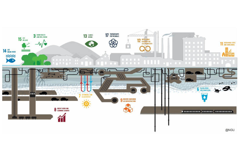

European policy is clear in its ambition to deliver a sustainable urban future for Europe. This research, led by BGS and the EuroGeoSurveys’ Urban Geology Expert Group, considers the role of urban geoscience in helping to achieve these ambitions by highlighting the relevance of geology to urban subsurface planning and wider policy.
Despite the lack of explicit reference to urban underground or subsurface space in key policy documents, the research identifies a significant number of priority urban issues for which geological characterisation is a pre-requisite (such as mitigation of climate impacts and delivering net zero energy) and where implementing nature-based solutions forms part of the answer.
Urban future
By 2050, it is likely that humanity will have become a predominantly urban species, with 70 per cent of the global population expected to be living in cities and the surrounding urban sprawl (International Organization for Migration, 2015).
Whilst cities deliver economic benefits, high urban populations place extreme pressures on land, the environment and natural resources, and are major contributors to climate change (Smith and Bricker, 2021). Urban centres only cover approximately 3 per cent of the land surface, but they account for more than 70 per cent of energy consumption and 75 per cent of carbon emissions (Smith and Bricker, 2021). The impact of urbanisation, therefore, extends far beyond its physical footprint.
Although cities are part of the problem, as centres of innovation, knowledge, and economic prosperity, they must also be a solution. Global programmes, including the UN Sustainable Development Goals (SDGs), recognise the role of cities in delivering climate targets and sustainable approaches. These global ambitions are also adopted at a European level, through, for example:
Urban geoscience establishes the need for city masterplans to include geological considerations, including hazard management, use of natural resources and nature-based solutions. These draw on a range of disciplines such as engineering geology, hydrogeology and environmental geology, and utilise a range of technologies such as geological modelling and remote sensing.
Urban strategies for subsurface management
One of the primary routes to embed subsurface information in city decision making is the development of underground masterplans and supplementary planning guidance for subsurface land uses.
Approaches to subsurface governance vary between countries; some focus on land-use zoning to protect future subsurface development, for example for future transport infrastructure, which is achieved through national planning policy. Others aim to protect rights to underground resources, such as water, minerals, oil and gas, through environmental regulation. The national-level approach to subsurface governance ultimately dictates the extent to which geological information is included within the planning process.
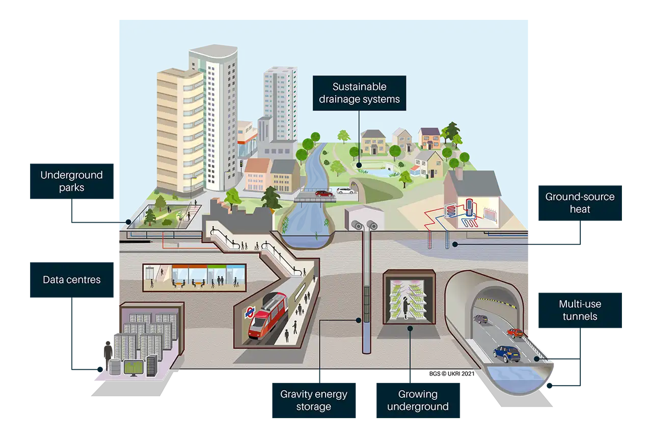
How the net zero cities of tomorrow might utilise subsurface space more sustainably. BGS © UKRI.
European policies
A review of some key European urban and environmental policies and strategies has been undertaken as part of this research, to assess the extent to which urban geoscience issues and opportunities are represented at a policy level. Even though the urban subsurface environment is not explicitly referenced and there is no direct mention of the role of geology, urban geosciences can make positive contributions to five key challenges:
- sustainable use of land
- climate impacts and mitigation
- transition to net zero energy
- implementation of nature-based solutions
- clean water

This research provides a unique perspective on recent advances in urban geoscience across Europe and, reassuringly, we see a strong line of sight between the research directions and policy needs. However, the dependencies between the policy objectives and geological context are far easier for the geologist to discern. The benefit of the EuroGeoSurveys’ Urban Geology Expert Group is that we are developing a cohort of scientists who are happy working across geological disciplines and at the boundary of their science to provide more innovative and collaborative solutions that speak to the needs of urban practitioners. We recognise that geology is only one piece of the puzzle for a sustainable urban future.
Stephanie Bricker, head of urban geoscience and spatial planning at BGS.
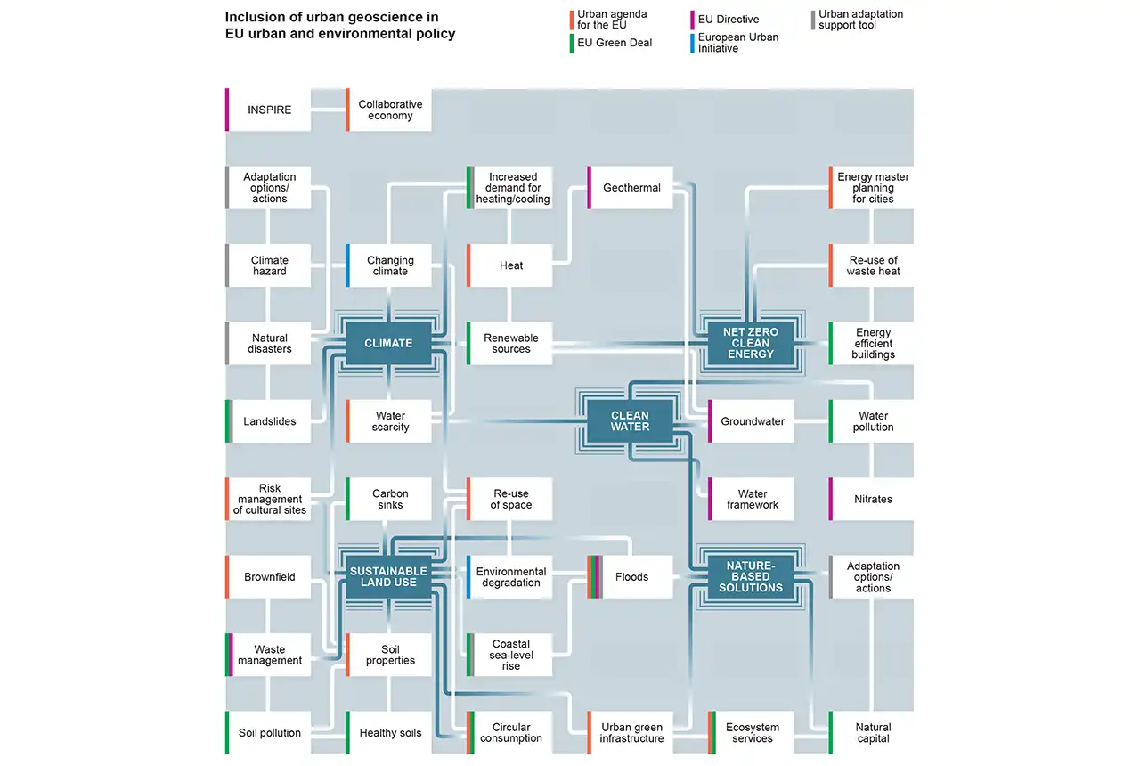
Network diagram illustrating priority policy topics of relevance to urban geology that are embedded in EU urban and environmental policy and the connections between them. BGS © UKRI.
An evolving science
The urban geoscience discipline is successfully evolving to deliver integrated urban science in response to these policy aims. We see a strong alignment between the policy themes and the current urban pressures and research priorities identified by urban geoscientists across Europe’s geological surveys.
The review of urban geoscience research priorities also shows that the discipline is broadening to embrace wider geo-environmental specialisms, including geothermal expertise, geo-data and informatics, geoheritage and science policy.
Demonstrating the value of urban geoscience for different urban challenges is a future priority. It is important for the recruitment of influential stakeholders in terms of, for example:
- the value of geological data for urban development
- demonstrating the multiple benefits of nature-based solutions
- risk reduction in hazardous urban environments
As one of the more accessible geological disciplines, urban geoscience even has a role in broader geological knowledge creation in aligned non-geological organisations, and in improving diversity within geological communities.
The role of the urban geoscientist as an agent of change to enhance integrated science, improve the accessibility of geological issues and accelerate the translation of national or regional geology to local settings and to urban policy drivers should not be underestimated.
Urban geology has rapidly evolved from an emerging field to one that is becoming increasingly recognised as crucial to bridge the divides between the many sectors that meet in the urban subsurface – underground infrastructure, energy systems, transport, geological storage, geoheritage, waste management, groundwater and soil health, natural and human-induced hazards. Increasing urbanisation coupled with climate change impacts will increasingly weigh on competing uses of the urban subsurface. Because of these competing uses, urban geologists play a key role in our ability to plan for future sustainable, climate-resilient cities.
Julie Hollis, secretary general at EuroGeoSurveys.
Further reading
The full report: Geoscience for Cities: delivering Europe’s sustainable urban future.
More information
International Organization for Migration. 2015. World Migration Report 2015. Migrants and Cities: New Partnerships to Manage Mobility. (Geneva, Switzerland: International Organization for Migration.). Available online: https://publications.iom.int/books/world-migration-report-2015-migrants-and-cities-new-partnerships-manage-mobility [accessed 1 May 2023]. ISBN: 978-92-9068-709-2.
Smith, M, and Bricker, S. 2021. SDG 11: Sustainable Cities and Communities. 259–282 in Geosciences and the Sustainable Development Goals, Sustainable Development Goals Series. Gill, J C, and Smith, M (editors.) (Cham, Switzerland: Springer.) DOI: https://doi.org/10.1007/978-3-030-38815-7_11
Relative topics
Related news

New NERC-funded project empowers young people to engage with environmental science
23/07/2026
BGS is part of a new, collaborative project, funded through NERC’s ‘Opening up the environment’ programme, helping the environmental research community become more accessible.

Geo-Explorers – after-school kids’ clubs
Event from 07/09/2026 to 07/12/2026
An after school club for junior geology enthusiasts

Building Europe’s geological future
20/07/2026
BGS scientists are contributing to a continent-wide initiative that is strengthening collaboration across borders to tackle shared subsurface challenges and unlock new opportunities.

Delving deep into mountains for future water security
16/07/2026
A BGS-led project is using new water-tracing investigation methods, geophysics and modelling to understand how water moves from mountains to the lowlands, helping to improve water security for billions of people.

Collecting beach pebbles: fun hobby but is it legal?
14/07/2026
The UK coastline will be inundated with keen holidaymakers this summer, many of whom will take a memento of their trip home in the shape of a pebble or two — but is it legal?

Updated national 3D model will determine the depth to the solid bedrock beneath our feet
13/07/2026
The BGS Superficial Deposit Thickness Model now includes an elevation model of geological rockhead for the first time, providing important data for civil engineers, geoscientists and environmental scientists.

UK’s world-class research organisations launch new collective
10/07/2026
The launch of the National Research Organisations Group brings together more than 100 science leaders to provide an authorativive voice on science, research policy and long-term investment.

Cheshire Geoenergy Observatory releases key geological datasets for UK thermal energy storage scheme design
09/07/2026
A new report and data packs from BGS will provide a unique resource for scientists working on the geology and hydrogeology of the Sherwood Sandstone Formation, an important aquifer and reservoir rock.

New geological mapping underway to help manage flooding along the River Tweed
08/07/2026
Scientists are surveying the Tweed catchment for the first time in over 100 years to enhance understanding of localised groundwater and improve flood forecasting.

Geological research in North Sea helping to safeguard subsea cables
06/07/2026
Subsea power and telecommunications cables are critical to the UK’s energy infrastructure and global connectivity, yet they remain vulnerable to damage from ship anchors, fishing activity and natural hazards.

UK Critical Minerals Intelligence Centre makes recommendations for the next UK criticality assessment
01/07/2026
CMIC has outlined the enhancements made to the next assessment update to ensure it is better tailored to the structure of the UK economy.

From archive to discovery: historical mineral reports support gold exploration in Scotland
25/06/2026
Digitised geological records show potential to unlock untapped mineral resources in Ardlochan, Argyllshire.