Deep-ocean current creates tsunami risk for Falkland Islands
16/03/2020 By BGS Press

The Falkland Islands are at risk from tsunamis caused by underwater landslides, according to new research by scientists from the British Geological Survey and Heriot-Watt University.
They found evidence of prehistoric submarine landslides in the Falkland Trough, 150km south of the Falkland Islands. The landslides are all in the same location, caused by one of Earth’s strongest currents, the Subantarctic Front. This current pushed sediment high up on the continental slope causing a drift, named Burdwood Drift by the researchers. Over time, a tipping point would then occur and cause a landslide.
Sediment has been accumulating again at the site and the seabed is so steep and unstable it will collapse – but scientists can’t tell when.

Professor David Tappin, a tsunami specialist at the British Geological Survey said:
‘Tsunamis from submarine landslides are still an underrated hazard, despite increasing recognition of their presence along most ocean margins. This new work identifies a previously unforeseen series of submarine landslides in the South Atlantic.
‘These landslides are thousands of years old, so the present day risk to local coastal regions from them is very low. However if a landslide happened today, it would be a different story. The present day submarine landslide tsunami hazard was highlighted at the end of 2018, when coastal landslides and volcanic collapse in Indonesia resulted in tsunamis which claimed numerous lives.’
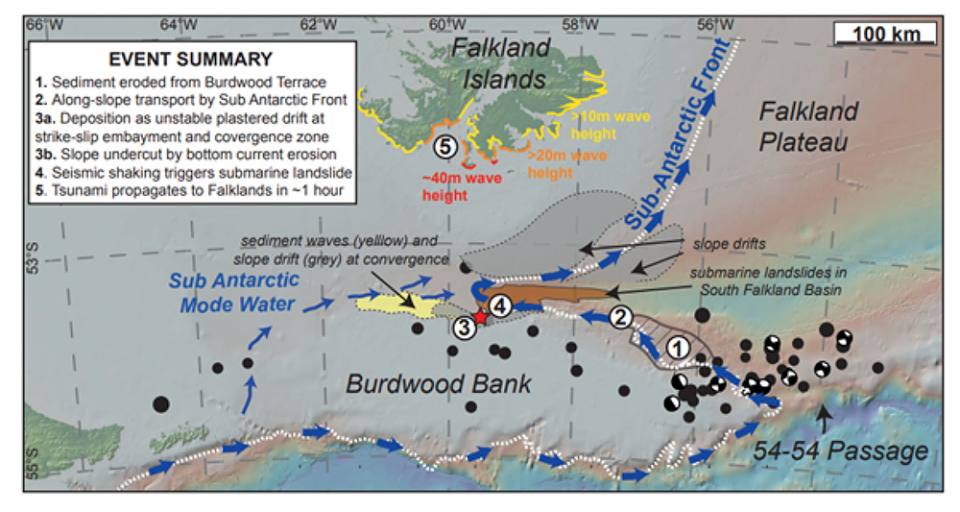
Nicholson et al. Figure 10 & visual abstract (2-column image).
Most large tsunamis, such as the Indian Ocean event Boxing Day tsunami in 2004, or the 2011 event in Japan, were caused by large earthquakes. However, landslides have also triggered tsunami waves, including the 1998 Papua New Guinea tsunami, the prehistoric Storegga landslide that inundated Scotland around 8000 years ago and most recently in 2018, on Sulawesi in Indonesia.
The team of researchers used seismic data to assess the density of sediments in three dimensions. The landslides deposited huge volumes of mud, sand and rocks on the ocean floor, much as an onshore landslide does.
Dr Uisdean Nicholson, a sedimentary geologist at Heriot-Watt University, said:
‘The large landslides shifted around 100 km3 of sediment – that’s enough to bury a city the size of Edinburgh under 400m of material. The large landslides happened once every million years or so. But we also found evidence of smaller landslides that generated tens of cubic kilometres of material and happened more frequently. These would still provide a real hazard.’
The team modelled the landslides to test whether they could have generated hazardous tsunamis and calculate whether future landslides would pose a risk to the Falkland Islands.
Dr Nicholson said:
‘The models show that, for a 100 km3 landslide event, the resultant wave would be up to 40 m high, and reach the Falklands about an hour after the event. Smaller and more frequent 10 km3 events could still cause a significant hazard, with likely wave heights of several metres affecting the capital Stanley.
‘We must understand more about these processes and the likelihood of another landslide, and whether it will cause a tsunami that could affect the nearby Falkland Islands.’
The research was funded by the Carnegie Institute and used seismic data and well data provided by Borders and Southern Petroleum and Rockhopper Exploration and the Falkland Island Government.
The report was published in Marine Geology: The Subantarctic Front as a sedimentary conveyor belt for tsunamigenic submarine landslides