BGS to deliver three-year groundwater flood forecasting service to support emergency response to flooding
BGS is delivering a national-scale early warning system for groundwater flooding, alongside the Environment Agency and the Met Office.
29/11/2021 By BGS Press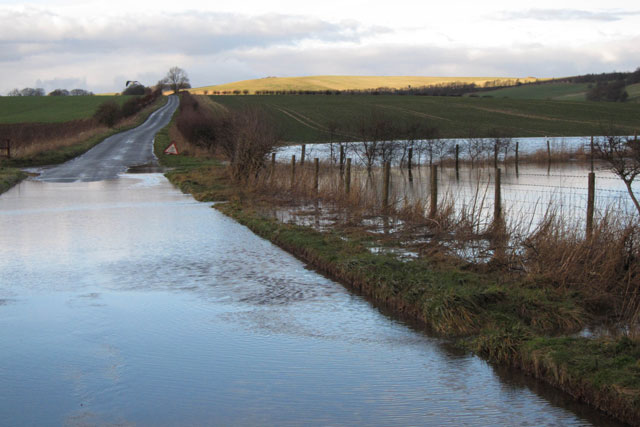

BGS has been appointed to forecast groundwater flooding for the Flood Forecasting Centre (FFC) until 2024.
BGS will deliver a three-year groundwater flood forecasting service (GWFFS), providing a national-scale early warning system for England for groundwater flooding.
The service officially went live at the beginning of November 2021 and is being used by the FFC to help inform their daily flood guidance statements, which are delivered to support the Category 1 and 2 emergency response community.
Groundwater flooding represents a significant part of the overall flood risk in the UK, but is challenging to forecast as it results from subsurface flow processes that are hard to observe and difficult to characterise.

The service not only builds on our expertise in national groundwater flood mapping and modelling, but also our continued collaboration with the Met Office and Environment Agency in delivering operational groundwater forecasts for other services such as the UK Hydrological Outlook. At the heart of the system is our AquiMod groundwater model software, which allows us to provide skillful forecasts quickly and at an appropriate scale, helping the FCC to deliver relevant information to those that need it.
The opportunity to provide essential data of this scale to the FCC, which combines meteorological and hydrological expertise with extensive regional- and local-scale knowledge and community engagement practices, will ensure there is a reliable link between science and the impact that flooding has on everyday lives.
Dr Jonathan Mackay, BGS groundwater flood forecasting service project lead.
The FCC, which is a working partnership between the Environment Agency and Met Office, uses flood forecast information to assess the likelihood, location and scale of groundwater flooding.
The GWFFS forms part of the FCC’s commitment to continually improve its ability to deliver skillful flood forecasts with more targeted information for emergency flood responders.
It’s great to have the expertise and skills of British Geological Survey hydrogeologists on board as partners to support the FFC. This service will enable the FFC to deliver timely and accurate groundwater flood forecasts to be used to assist emergency responders with tactical, strategic and operational planning decisions.
Steve Stanbridge, Flood Forecasting Centre.
Relative topics
Related news

Isotopes and science: my student placement at BGS
08/04/2026
Industrial placements at BGS for undergraduate students give real-life experience of working in laboratories and learning different analytical techniques.

Updated geological assessment of the Southern North Sea set to underpin future offshore infrastructure development
25/03/2026
The first regional assessment for 30 years will support offshore marine and subsurface planning for the UK’s low-carbon energy infrastructure, including the 2030 target of 45 to 50 GW generated through offshore wind.

New research could help provide a more reliable water supply for millions in rural Africa
24/03/2026
A new BGS-led study has revealed crucial insights into the longstanding challenges affecting the reliability and performance of rural water supply infrastructure in sub-Saharan Africa.

Call for new members and Chair to join the NERC facilities steering committees
25/02/2026
New members are needed to join the committees over the next four years.

Your views wanted: developing a geothermal energy subsurface data portfolio
24/02/2026
BGS is aiming to support the growth of the sector by providing the best-available, location-specific geothermal and ground source heat information as an accessible product or service.

Map of BGS BritPits showing the distribution of worked mineral commodities across the country
18/02/2026
BGS’s data scientists have generated a summary map of the most commonly extracted mineral commodities by local authority area, demonstrating the diverse nature of British mineral resources.

Funding awarded to map the stocks and flows of technology metals in everyday electronic devices
12/02/2026
A new BGS project has been awarded Circular Electricals funding from Material Focus to investigate the use of technology metals in everyday electrical items.

New UK/Chile partnership prioritises sustainable practices around critical raw materials
09/02/2026
BGS and Chile’s Servicio Nacional de Geología y Minería have signed a bilateral scientific partnership to support research into critical raw materials and sustainable practices.

Extensive freshened water confirmed beneath the ocean floor off the coast of New England for the first time
09/02/2026
BGS is part of the international team that has discovered the first detailed evidence of long-suspected, hidden, freshwater aquifers.

Funding secured to help mitigate ground risk in UK construction sector
05/02/2026
The BGS Common Ground project has been awarded new funding to help unlock the value of ground investigation data.

Can sandstones under the North Sea unlock the UK’s carbon storage potential?
02/02/2026
For the UK to reach its ambitious target of storing 170 million tonnes of carbon dioxide per year by 2050, it will need to look beyond the current well-studied geographical areas.

Quaternary UK offshore data digitised for the first time
21/01/2026
The offshore wind industry will be boosted by the digitisation of a dataset showing the Quaternary geology at the seabed and the UK’s shallow subsurface.