Airlines, shipping companies and sleigh drivers rush to update crucial navigation systems ahead of Christmas rush
Release of major upgrade to a new model tracking magnetic north prompts global reset of satellite tracking systems across trade and passenger transport routes.
17/12/2024 By BGS Press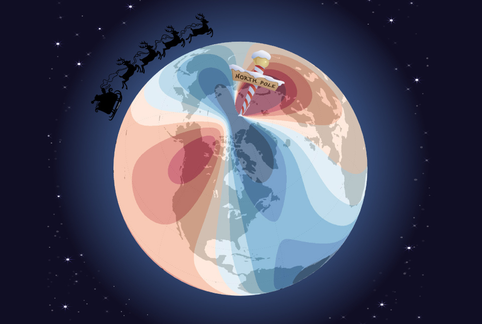

Hundreds of thousands of mariners, airline operators and North Pole-based gift distribution specialists will be rushing to update their navigation systems after the launch of a new model tracking magnetic north, which is crucial to the accuracy of global positioning systems (GPS) that are relied upon across the world.
In partnership with the UK Defence Geographic Centre and the US National Geospatial-Intelligence Agency (NGA), BGS and the US National Oceanic and Atmospheric Administration (NOAA) have teamed up to update the World Magnetic Model (WMM).
The WMM is the standard model used by the United Kingdom and the United States governments, including the U.S. Federal Aviation Administration and the U.S. Department of Defense, as well as organizations with an international remit such as the North Atlantic Treaty Organization (NATO), the International Hydrographic Organization and the UK Hydrographic Office.
The model comprises a series of magnetic field maps that track changes in the magnetic field, such as the spot at which compass needles point in the northern hemisphere. To ensure pinpoint accuracy, it is crucial that the shifts in magnetic north, which are caused by flow of the liquid iron in the outer core of the Earth, are taken into account in the electronic equipment that is trusted to guide global trade and enable the safe transit of travellers across the planet. From GPS-enabled mobile phones to nuclear submarines, this improved resolution update will allow navigation with more accuracy than ever before to take place in the run up to Christmas — vital for all those who do not have a red nose to follow.

The WMM is officially released today, ensuring users can have the most up-to-date information so they can continue to navigate accurately for the next five years.
The current behaviour of magnetic north is something that we have never observed before. Magnetic north has been moving slowly around Canada since the 1500s but, in the past 20 years, it accelerated towards Siberia, increasing in speed every year until about five years ago, when it suddenly decelerated from 50 to 35 km per year, which is the biggest deceleration in speed we’ve ever seen.
Dr William Brown, global geomagnetic field modeller at BGS.
While each model predicts how magnetic north will shift over the five-year period to limit any error, the change will have an impact on travellers.
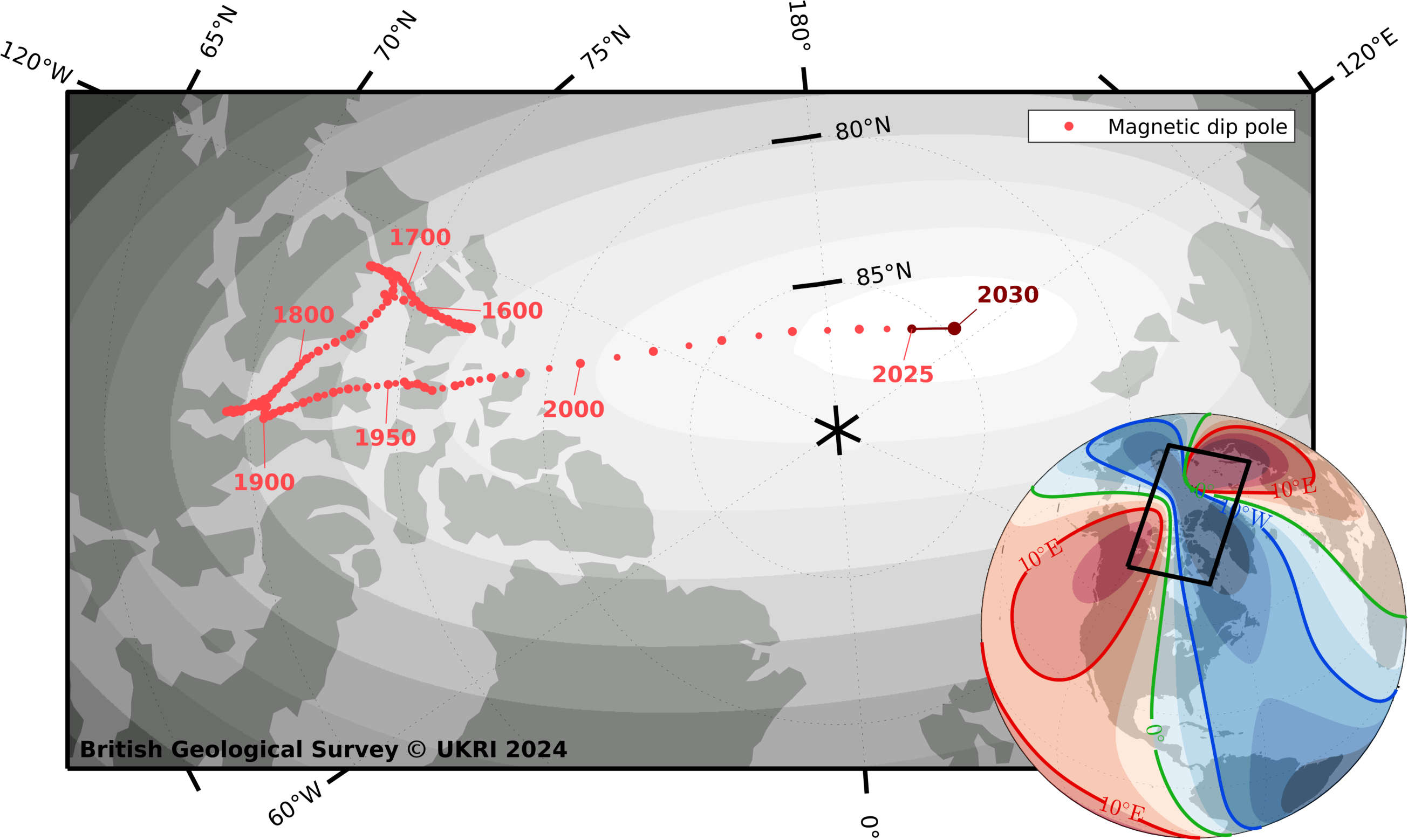
Magnetic north pole locations from 1590 to 2030. BGS © UKRI and © Wessel, P., and W. H. F. Smith (1996), A global, self-consistent, hierarchical, high-resolution shoreline database, J. Geophys. Res., 101(B4), 8741–8743, doi:10.1029/96JB00104. (v2.3.6).
Imagine someone was planning to travel by sleigh from a chimney top in South Africa to a snow covered-roof in the UK, a journey of around 8500 km. Using the previous WMM and setting off just one degree off-course, he would end up approximately 150 km away from where he should[1]. With a margin of error of only a few inches between chimney flues, this could cause significant issues.
Values from the updated model can now be calculated, and the WMMHR2025 and the WMM2025 are available for download.
More information
This year marks the first year that two versions of the model are being released. In addition to WMM2025, the 2025 update features the first-ever WMM High-Resolution 2025, which includes improved spatial resolution of approximately 300 km at the equator compared to the standard spatial resolution of 3300 km at the equator. Higher resolution provides greater directional accuracy through enhanced precision in the data.
Sponsored by NGA and the Defence Geographic Centre, the WMM is produced by BGS and NOAA’s National Centers for Environmental Information. It is the standard model used by the US Department of Defense, the UK Ministry of Defence, NATO and the International Hydrographic Organization for navigation, attitude and heading referencing systems using the geomagnetic field. It is also used widely in civilian navigation and heading systems. The WMM is updated every five years and its accuracy is validated annually to ensure it falls within the WMM military specification.
About NGA
NGA delivers world-class geospatial intelligence that provides a decisive advantage to policymakers, warfighters, intelligence professionals and first responders.
NGA is a unique combination of intelligence agency and combat support agency. It is the world leader in timely, relevant, accurate and actionable geospatial intelligence. NGA enables the US intelligence community and the Department of Defense to fulfill the president’s national security priorities to protect the nation.
For more information about NGA, visit us online at nga.mil, Instagram, LinkedIn, Facebook and X/Twitter
[1] It is believed that, while such a traveller may not rely primarily on satellite navigation, no logistical expert delivering hundreds of years of consistent service would not have such technology as a backup in case of emergency.
Relative topics
Related news

New NERC-funded project empowers young people to engage with environmental science
23/07/2026
BGS is part of a new, collaborative project, funded through NERC’s ‘Opening up the environment’ programme, helping the environmental research community become more accessible.

Delving deep into mountains for future water security
16/07/2026
A BGS-led project is using new water-tracing investigation methods, geophysics and modelling to understand how water moves from mountains to the lowlands, helping to improve water security for billions of people.

Updated national 3D model will determine the depth to the solid bedrock beneath our feet
13/07/2026
The BGS Superficial Deposit Thickness Model now includes an elevation model of geological rockhead for the first time, providing important data for civil engineers, geoscientists and environmental scientists.

UK’s world-class research organisations launch new collective
10/07/2026
The launch of the National Research Organisations Group brings together more than 100 science leaders to provide an authorativive voice on science, research policy and long-term investment.

Cheshire Geoenergy Observatory releases key geological datasets for UK thermal energy storage scheme design
09/07/2026
A new report and data packs from BGS will provide a unique resource for scientists working on the geology and hydrogeology of the Sherwood Sandstone Formation, an important aquifer and reservoir rock.

New geological mapping underway to help manage flooding along the River Tweed
08/07/2026
Scientists are surveying the Tweed catchment for the first time in over 100 years to enhance understanding of localised groundwater and improve flood forecasting.

Geological research in North Sea helping to safeguard subsea cables
06/07/2026
Subsea power and telecommunications cables are critical to the UK’s energy infrastructure and global connectivity, yet they remain vulnerable to damage from ship anchors, fishing activity and natural hazards.

UK Critical Minerals Intelligence Centre makes recommendations for the next UK criticality assessment
01/07/2026
CMIC has outlined the enhancements made to the next assessment update to ensure it is better tailored to the structure of the UK economy.

From archive to discovery: historical mineral reports support gold exploration in Scotland
25/06/2026
Digitised geological records show potential to unlock untapped mineral resources in Ardlochan, Argyllshire.

UK and Philippines scientists investigate natural hydrogen generation processes at atomic scale
22/06/2026
BGS researchers were granted access to use the Diamond Light Source facility in order to study hydrogen in light brighter than the sun.

Shortage of end-of-life materials presents challenge to UK critical minerals security
17/06/2026
A new report by the UK Critical Minerals Intelligence Centre reveals insufficient end-of-life material stocks present a supply risk over the coming decade, but offer significant long-term potential to meet critical mineral demand through recycling.

UK geothermal catalogue receives update
16/06/2026
BGS releases the second digital version of the UK geothermal catalogue of subsurface temperature and rock thermal conductivity measurements and heat flow calculations.