BGS’s groundwater modellers, geologists and hydrogeologists have developed a numerical model that provides a unique tool for simulating groundwater resources at the national scale, covering England, Wales, and Scotland — the British Groundwater Model (BGWM).
Why is the BGWM needed?
Groundwater accounts for the largest volume of liquid fresh water on Earth and represents an essential source of fresh water for public and private supply, agriculture, industry and recreation across the UK and globally. Computer models allow us to visualise groundwater flow and understand temporal variations in groundwater levels and interactions between groundwater and surface waters. These models are essential tools for effective water-resource management and for making predictions about the future.
Model development and results
The BGWM is implemented in the finite-volume code MODFLOW 6 using an unstructured grid with a minimum resolution of 1 km × 1 km in in the horizontal plane and 50 m along the vertical direction. The spatial parameterisation of the model is consistent with the geometries of 14 hydrogeological units (HUs) in a national-scale, 3D geological model. The HUs include geological formations classified as major aquifers, such as the Chalk Group as well as minor aquifers and aquitards. Hydrogeological input parameters for the HUs were calibrated against measured groundwater levels and estimated baseflows using the PEST software.
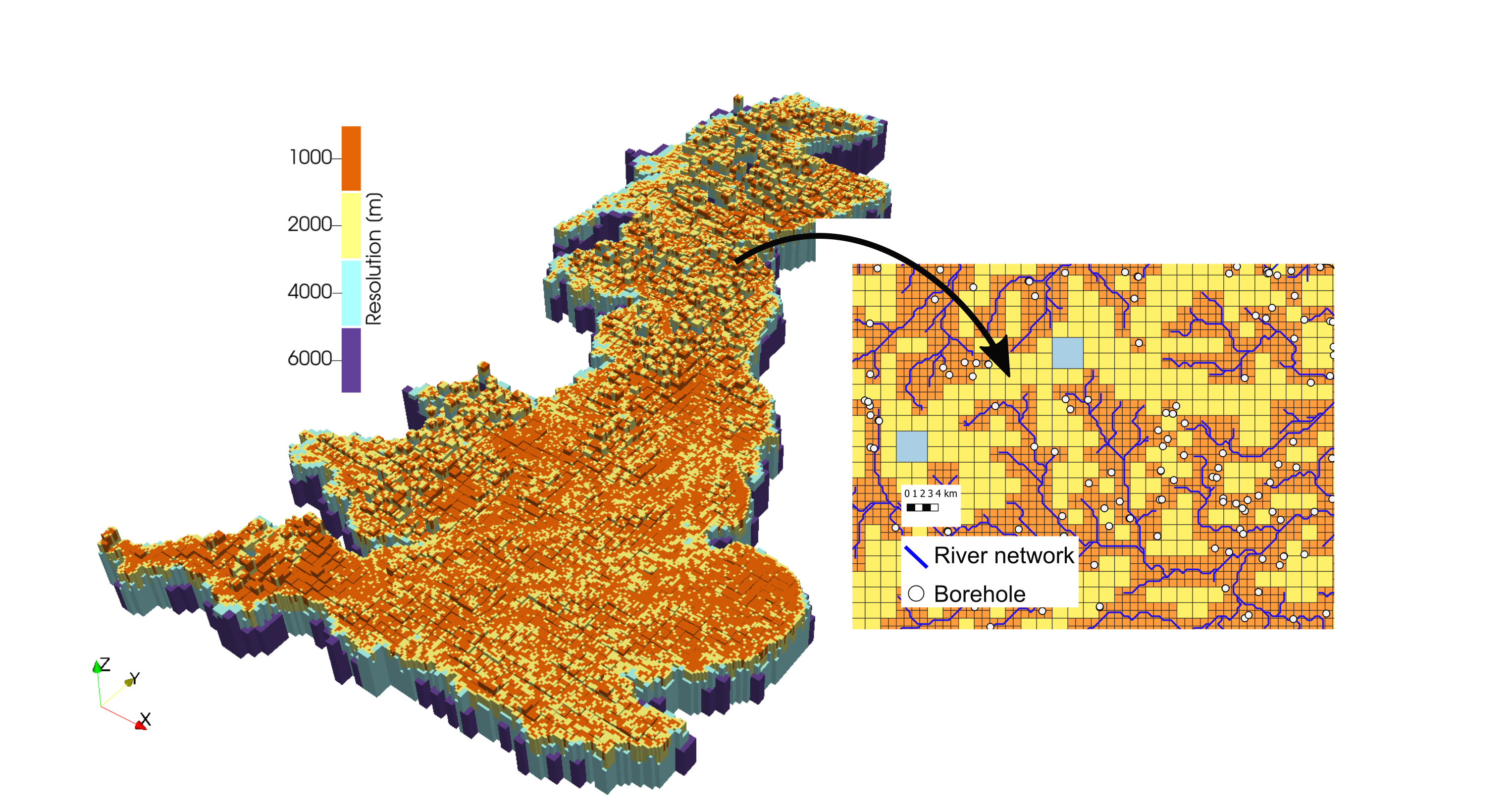

Numerical grid with refinement (up to 1 km) around the river network and boreholes. BGS © UKRI.
The current transient version of the model (Bianchi et al., 2024) runs from 1970 to 2018, with monthly time steps. It is driven by our national-scale recharge model developed using the BGS distributed recharge model code ZOODRM (Mansour et al., 2018). This model takes rainfall and potential evaporation and combines them with land use, geology, land-surface elevation and river networks to calculate recharge on a daily basis over Great Britain. Groundwater pumping, groundwater discharge to the sea and river/aquifer interactions are considered as boundary conditions in the BGWM.
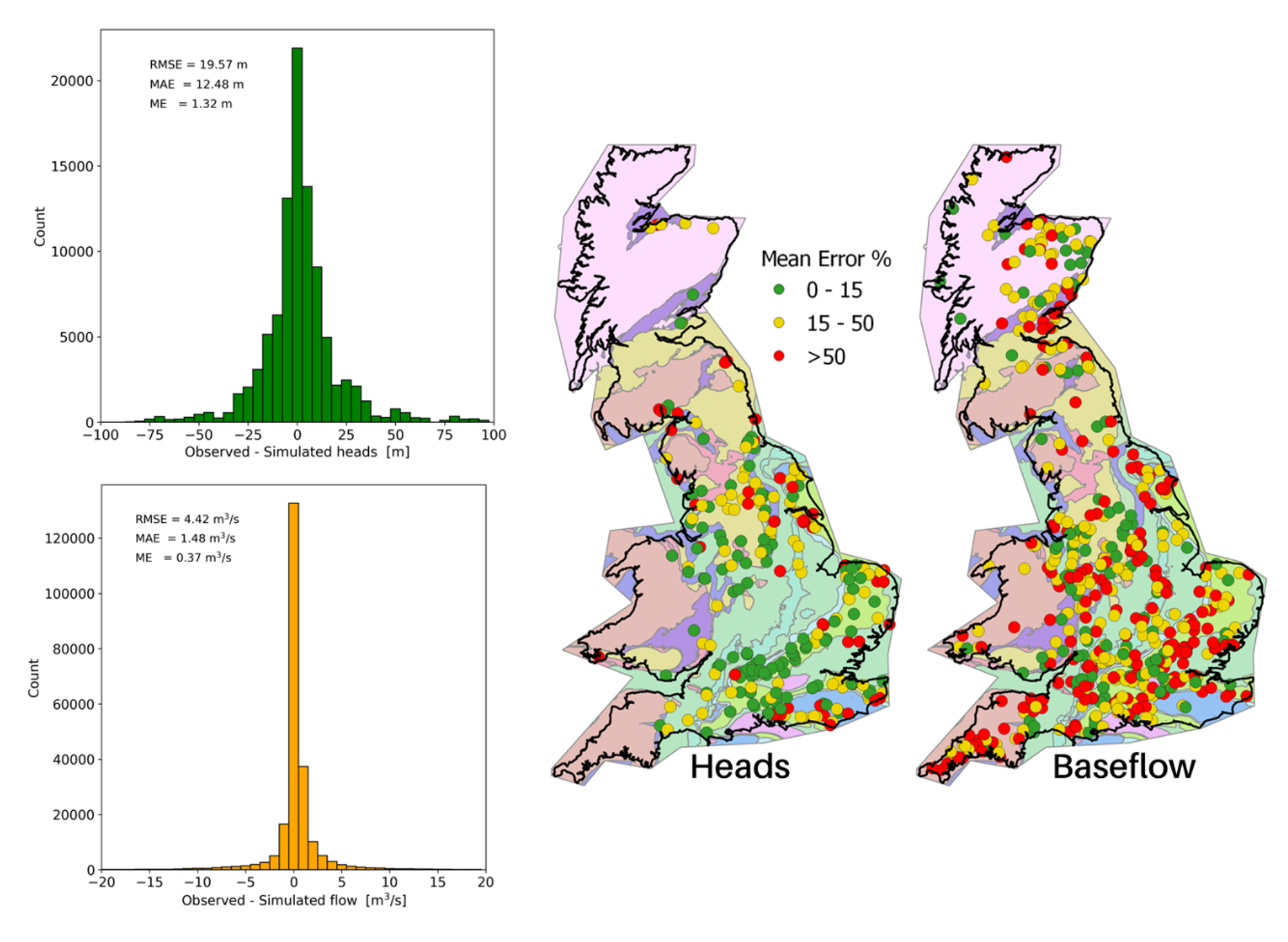
Observed vs. simulated data and mean prediction error for baseflow and groundwater levels. BGS © UKRI.
Comparisons between simulated and observed data show that the BGWM provides a fairly accurate simulation of groundwater levels and baseflows. Therefore, the BGWM provides a holistic simulation platform for a wide range of applications including estimations of national and regional groundwater budgets. Planned future upgrades will address some of the current limitations with the objective of developing a robust management tool to test and validate hypotheses regarding the evolution of groundwater resources in British aquifers under climatic and population changes.
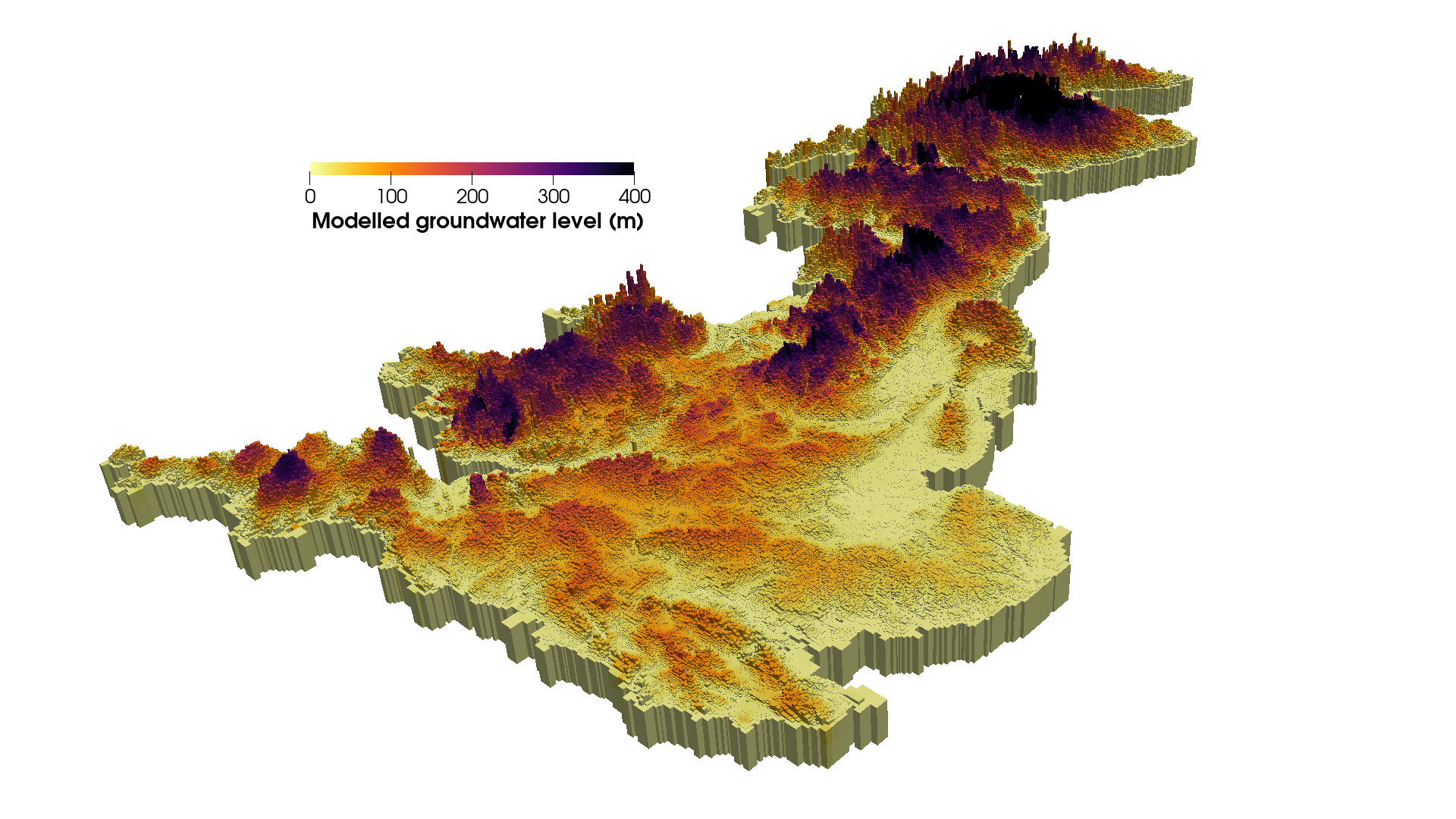
Modelled steady-state groundwater levels. BGS © UKRI.
Funding
The BGWM was developed on the Hydro-JULES research project, supported by NERC’s Multi-Centre National Capability funding programme. The Hydro-JULES project, which aims to improve the understanding and simulation of the terrestrial hydrological cycle within the UK and globally, is led by BGS, the UK Centre for Ecology & Hydrology, the National Centre for Atmospheric Science and the National Centre for Earth Observation.
Contact
For further information please contact Dr Marco Bianchi.
Further reading
Bianchi, M, Scheidegger, J, Hughes, A, Jackson, C, Lee, J, Lewis, M, Mansour, M, Newell, A, O’Dochartaigh, B, Patton, A, and Dadson, S. 2024. Simulation of national-scale groundwater dynamics in geologically complex aquifer systems: an example from Great Britain. Hydrological Sciences Journal, Vol. 69(5), 572–591. DOI: https://doi.org/10.1080/02626667.2024.2320847
Mansour, M M, Wang, L, Whiteman, M, and Hughes, A G. 2018. Estimation of spatially distributed groundwater potential recharge for the United Kingdom. Quarterly Journal of Engineering Geology and Hydrogeology, Vol. 51, 247–263. DOI: https://doi.org/10.1144/qjegh2017-051