The BGS was commissioned by Defra (October 2011–March 2012) to provide guidance on what ‘normal’ levels of contaminant concentrations are in English soils in support of the revision of the Part 2A Contaminated Land Statutory Guidance.
- Project summary
- Table of normal background concentrations (NBCs)
- GIS resources (domain polygons)
- Map viewer: contaminants in the soils of Englan
- Project reports and guidance sheets
The project is summarised in an Open Access publication:
Ander, EL, Johnson CC, Cave, MR, Palumbo-Roe, B, Nathanail, P and Lark, RM. 2013. Methodology for the determination of normal background concentrations of contaminants in English soil. Science of The Total Environment, Volumes 454–455, 1 June 2013, Pages 604-618
Project summary
Initially four contaminants in topsoils from England were investigated:
- arsenic
- asbestos
- benzo-[a]-pyrene (BaP)
- lead
This work was extended to a further four contaminants, which enabled the methodologies that were developed to be tested by a larger range of contaminants:
- cadmium
- copper
- mercury
- nickel
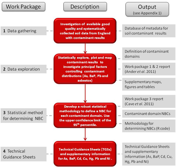

Project workflow: normal background concentrations (NBCs) of contaminants in English soils. BGS © UKRI.
The first phase of the project gathered soil datasets that were:
- nationally extensive
- systematically collected, so a broad range of land uses were represented
- collected and analysed to demonstrably and acceptable levels of quality
Information on the soil contaminant concentrations in urban areas was of particular importance as the normal background is considered to be a combination of both natural and diffuse anthropogenic contributions.
Issues of soil quality are most important in areas where these affect most people, namely, the urban environment.
The two principal datasets used in this work are the BGS G-BASE rural and urban topsoils (37 269 samples) and the English National Soil Inventory topsoils (4864 samples), re-analysed at our laboratories by XRFS, so both datasets were highly compatible.
These two datasets provided results for inorganic element contaminants, though results for mercury and BaP are drawn from a variety of different and much less extensive sources.
The second phase of the project explored the data, focusing on contaminant spatial variability and population distributions with the aim of investigating whether normal levels of contaminants could be quantified as normal background concentrations (NBCs).
These are attributed to different areas, defined here as ‘domains’, for each contaminant based on factors observed to contribute to variable and higher concentrations.
The three most important contributing factors are:
- the underlying parent material upon which the soil has formed
- non-ferrous metalliferous mineralisation and associated mining activity
- urbanisation
There was insufficient information about natural concentrations of asbestos in soils so it was not possible to determine NBCs for this contaminant.
A robust statistical methodology was developed in the third phase of the project to deliver values for contaminant domain NBCs. This is based on a study of a contaminant’s population distribution.
Using statistical measures (e.g. skewness coefficient; octile skew) as a guide, appropriate transformations are applied to the data to reduce the influence of outlying data points likely to have been caused by point-source contamination.
Percentiles for the domain datasets for each contaminant were generated along with calculations of percentile confidence intervals. The upper limit for a NBC has been defined as the upper confidence limit of the 95th percentile.
The NBCs can be used at national to regional scales as a guide as to what normal levels of contaminant concentrations are in English soils. This methodology can be applied by those who have their own sufficient and representative datasets at a local scale.
For the contaminants for which NBCs could be determined, a series of technical guidance sheets (TGSs) have been written accompanied by supplementary information, which includes many of the project outputs.
Table of normal background concentrations
The table shows the domain normal background concentrations (NBCs) for the contaminants studied in English soils (unless otherwise stated).
The project has defined the upper limit of NBCs as the upper 95 per cent confidence limit of the 95th percentile.
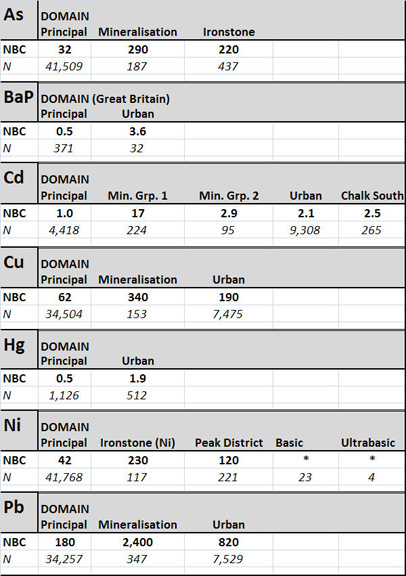
Summary of domain normal background concentrations (NBCs) for the contaminants studied in this project. BGS © UKRI.
Normal background concentrations for the contaminant domains are our best effort to define what is the upper limit of ‘normal’ levels of contaminants in soil as described by the Part 2A contaminated land statutory guidance (SG7). They are not a planning or risk assessment tool and must be used in the context of the SG in the manner described in the technical guidance sheets.
The domain boundaries are available as GIS polygons. More details about the domains are given in the contaminant technical guidance sheets and associated supplementary information.
GIS resources
Some of the GIS resources produced by the project are served as a Web Map Service (WMS). These include:
- domain polygons
- arsenic (As)
- benzo-[a]-pyrene (BaP)
- cadmium (Cd)
- copper (Cu)
- lead (Pb)
- mercury (Hg)
- nickel (Ni)
- urbanisation index polygons defined from GLUD database
- polygons defining areas of metalliferous mining derived from the Ove Arup database
Before using these polygons, users should read the descriptions of their derivation and their limitations given in Section 3 of Ander et al. (2011).
Web map services (WMS) are an industry standard protocol for serving georeferenced images across the web. They were developed and first published by the Open Geospatial Consortium (OGC) in 2000. Since then, WMS have had a steady uptake and are being increasingly used in traditional desktop-based GIS and web-based GIS systems, including Google Earth.
Interpolated map viewer: contaminant distributions in English soils
The G-BASE regional and urban topsoils and the National Soil Inventory (NSI) (reanalysed by XRFS) samples provide more than 42 000 sample points across England.
NSI samples cover all of England at a density of one site per 25 km2. G-BASE samples are collected at a far higher density, urban samples at four sites per 1 km2 and rural samples at one site per 2 km2. However, the G-BASE sample coverage (of analysed topsoils) is only for central and eastern England.
A selection of cities have been mapped including, most recently, the London area (London Earth). With nearly 7000 sampling sites, this represents the world’s largest systematic sampling of an urban area.
For the inorganic element contaminants (Hg excepted) results from these soils can be used to produce contaminant maps for England by extrapolating between sites to model images of the distribution of contaminants in the soils of England.
These maps are produced using ArcGIS v9.3 using an inverse distance squared weighting option, cells of 1000 m and a search radius of 5000 m. The geochemical images show the great variability of contaminant concentrations across England.
Much of this variability can be attributed to the underlying parent material on which a soil has formed. This may simply be from the weathering of certain rock types enriched in a particular contaminant or from non-ferrous metalliferous mineralisation with which the contaminant is associated, either as the main ore mineral or an accessory.
The anthropogenic activity associated with mining and associated processes (e.g. smelting) has left a legacy of diffuse pollution in many areas of England and, as detailed in the revised statutory guidance (Sections 3.21–3.26), such diffuse pollution can be considered as part of the widespread and typical contaminant levels for that region.
The national soil contaminant maps for England are viewable in the geochemistry map viewer. These maps, along with the non-interpolated maps for Hg and BaP, are available in the technical guidance supplementary information (see below).
Project reports and guidance sheets
The following are reporting deliverables from the project are available in NORA and can be downloaded from Defra.
Reports
Ander, E L, Cave, M R, Johnson, C C, and Palumbo-Roe, B. 2011. Normal background concentrations of contaminants in the soils of England. Available data and data exploration. British Geological Survey Commissioned Report, CR/11/145.
Ander, E L, Cave, M R, Johnson, C C, and Palumbo-Roe, B. 2012. Normal background concentrations of contaminants in the soils of England. Results of the data expoloration for Cu, Ni, Cd and Hg. British Geological Survey Commissioned Report, CR/12/041.
Cave, M R, Johnson, C C, Ander, E L, and Palumbo-Roe, B. 2012. Methodology for the determination of normal background contaminant concentrations in English soils. British Geological Survey Commissioned Report, CR/12/003.
Johnson, C C, Ander, E L, Cave, M R, and Palumbo-Roe, B. 2012. Normal background concentrations (NBCs) of contaminants in English soils: Final project report. British Geological Survey Commissioned Report, CR/12/035.
Technical guidance
Defra. 2012. Technical guidance sheet on normal levels of contaminants in English soils: arsenic. Department for Environment, Food and Rural Affairs (Defra), Soils R&D Project SP1008, Technical Guidance Sheet No. TGS01.
Defra, 2012. Technical guidance sheet on normal levels of contaminants in English soils: arsenic – supplementary information. Department for Environment, Food and Rural Affairs (Defra), Soils R&D Project SP1008, Technical Guidance Sheet No. TGS01s.
Defra. 2012. Technical guidance sheet on normal levels of contaminants in English soils: lead. Department for Environment, Food and Rural Affairs (Defra), Soils R&D Project SP1008, Technical Guidance Sheet No. TGS02.
Defra. 2012. Technical guidance sheet on normal levels of contaminants in English soils: lead – supplementary information. Department for Environment, Food and Rural Affairs (Defra), Soils R&D Project SP1008, Technical Guidance Sheet No. TGS02s.
Defra. 2012. Technical guidance sheet on normal levels of contaminants in English soils: copper. Department for Environment, Food and Rural Affairs (Defra), Soils R&D Project SP1008, Technical Guidance Sheet No. TGS03.
Defra. 2012. Technical guidance sheet on normal levels of contaminants in English soils: copper – supplementary information. Department for Environment, Food and Rural Affairs (Defra), Soils R&D Project SP1008, Technical Guidance Sheet No. TGS03s.
Defra. 2012. Technical guidance sheet on normal levels of contaminants in English soils: benzo[a]-pyrene. Department for Environment, Food and Rural Affairs (Defra), Soils R&D Project SP1008, Technical Guidance Sheet No. TGS04.
Defra. 2012. Technical guidance sheet on normal levels of contaminants in English soils: benzo-[a]-pyrene – supplementary information. Department for Environment, Food and Rural Affairs (Defra), Soils R&D Project SP1008, Technical Guidance Sheet No. TGS04.
Defra. 2012. Technical guidance sheet on normal levels of contaminants in English soils: nickel. Department for Environment, Food and Rural Affairs (Defra), Soils R&D Project SP1008, Technical Guidance Sheet No. TGS05.
Defra. 2012. Technical guidance sheet on normal levels of contaminants in English soils: nickel – supplementary information. Department for Environment, Food and Rural Affairs (Defra), Soils R&D Project SP1008, Technical Guidance Sheet No. TGS05s.
Defra. 2012. Technical guidance sheet on normal levels of contaminants in English soils: cadmium. Department for Environment, Food and Rural Affairs (Defra), Soils R&D Project SP1008, Technical Guidance Sheet No. TGS06.
Defra. 2012. Technical guidance sheet on normal levels of contaminants in English soils: cadmium – supplementary information. Department for Environment, Food and Rural Affairs (Defra), Soils R&D Project SP1008, Technical Guidance Sheet No. TGS06s.
Defra. 2012. Technical guidance sheet on normal levels of contaminants in English soils: mercury. Department for Environment, Food and Rural Affairs (Defra), Soils R&D Project SP1008, Technical Guidance Sheet No. TGS07.
Defra. 2012. Technical guidance sheet on normal levels of contaminants in English soils: mercury – supplementary information. Department for Environment, Food and Rural Affairs (Defra), Soils R&D Project SP1008, Technical Guidance Sheet No. TGS07s.
Report
Ander, E L, Cave, M R and Johnson, C C. 2013. Normal background concentrations of contaminants in the soils of Wales. Exploratory data analysis and statistical methods. British Geological Survey Commissioned Report, CR/12/107.
Technical guidance
Defra. 2013. Technical guidance on normal levels of contaminants in Welsh soil: arsenic. British Geological Survey (Keyworth, Nottingham) and Defra (London), Soils R&D Project SP1008.
Defra. 2013. Technical guidance on normal levels of contaminants in Welsh soil: BaP. British Geological Survey (Keyworth, Nottingham) and Defra (London), Soils R&D Project SP1008.
Defra. 2013. Technical guidance on normal levels of contaminants in Welsh soil: cadmium. British Geological Survey (Keyworth, Nottingham) and Defra (London), Soils R&D Project SP1008.
Defra. 2013. Technical guidance on normal levels of contaminants in Welsh soil: copper. British Geological Survey (Keyworth, Nottingham) and Defra (London), Soils R&D Project SP1008.
Defra. 2013. Technical guidance on normal levels of contaminants in Welsh soil: lead. British Geological Survey (Keyworth, Nottingham) and Defra (London), Soils R&D Project SP1008.
Defra. 2013. Technical guidance on normal levels of contaminants in Welsh soil: mercury. British Geological Survey (Keyworth, Nottingham) and Defra (London), Soils R&D Project SP1008.
Defra. 2013. Technical guidance on normal levels of contaminants in Welsh soil: nickel. British Geological Survey (Keyworth, Nottingham) and Defra (London), Soils R&D Project SP1008.
Further information
You may also be interested in:
G-BASE: environmental geochemistry
In addition to expertise in geochemical mapping, BGS geochemists are involved in numerous activities and research that relate to the collection of geochemical samples, the use of geochemical baseline data and the interpretation of those as part of a wide range of geoscientific and environmental studies.
GeoIndex (onshore)
Search BGS datasets using GeoIndex, a map-based index of a wealth of information that we have collected or have obtained from other sources.
OpenGeoscience
Accessing maps and downloading data, scans, photos and other information via BGS’s free OpenGeoscience service.