Quaternary UK offshore data digitised for the first time
The offshore wind industry will be boosted by the digitisation of a dataset showing the Quaternary geology at the seabed and the UK’s shallow subsurface.
21/01/2026 By BGS Press

BGS has developed a new, national-scale, offshore dataset that shows the distribution of previously interpreted Quaternary rock layers in the shallow subsurface of the UK continental shelf.
The BGS Offshore Quaternary 250K dataset comprises a compilation of legacy BGS 1:250 000 Quaternary geology map sheets, which were first published in the late 1980s to early 1990s. Large areas of the UK offshore are covered at a scale of 1:250 000 and this is the first time these map sheets have been digitised and merged together.
The dataset is made up of vector polygons, each representing an area where a particular formation has been mapped. The legacy map sheet interpretations have not been modified during the digitisation; they are presented in their original form and have been ‘mosaiced’ together as a single digital product.
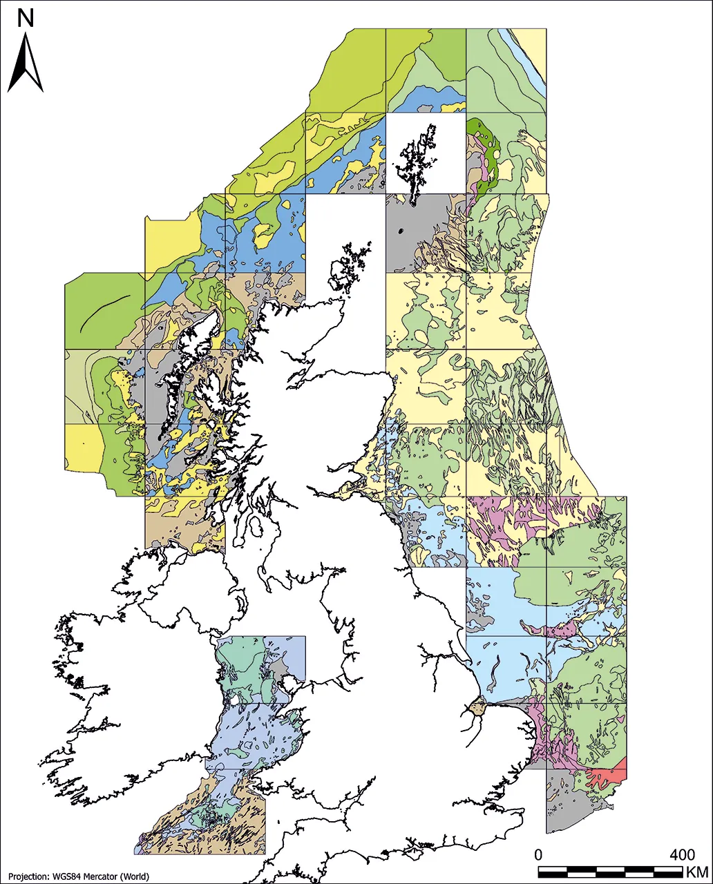
The dataset displayed by stratigraphical domain. BGS © UKRI. Coastline from Esri World Countries layer. Layer contains data from Esri, Garmin International, Inc., U.S. Central Intelligence Agency (The World Factbook), and International Organization for Standardization (ISO). Basemap created using ArcGIS. Copyright © Esri 2026. All rights reserved. www.esri.com
The dataset will help users, particularly those in the offshore renewables sector, to understand the stratigraphy that was mapped historically in a particular area and can be used for reference when completing site investigations.

The principal drive behind this release is to make original 1:250 000 map data available in a digital format. Although work to refine Quaternary stratigraphical frameworks is ongoing, the map compilation is not informed by new data or analyses.
The Offshore Quaternary 250K dataset is the first time that these legacy offshore map sheets will be digitised, making it easier for users to access the data than ever before.
Andrew Dyson, marine geoscientist at BGS.
Relative topics
Related news

New geological maps of Berwick-upon-Tweed to help future-proof natural water supply
20/05/2026
Scientists have mapped the geology under the town to better understand the groundwater system to inform decisions around abstraction.

UK scientists unite for seabed mapping survey of the UK’s south-west coastline
15/04/2026
BGS geologists join research voyage, gathering crucial geological data to support offshore energy and infrastructure projects.

Isotopes and science: my student placement at BGS
08/04/2026
Industrial placements at BGS for undergraduate students give real-life experience of working in laboratories and learning different analytical techniques.

Updated geological assessment of the Southern North Sea set to underpin future offshore infrastructure development
25/03/2026
The first regional assessment for 30 years will support offshore marine and subsurface planning for the UK’s low-carbon energy infrastructure, including the 2030 target of 45 to 50 GW generated through offshore wind.

PhD adventures in Copenhagen, Denmark: revealing past recovery processes of tropical forest systems through ancient environmental DNA
12/03/2026
PhD student Chris Bengt visited the University of Copenhagen to carry out very delicate extraction of aeDNA from lake-sediment cores, in the hopes of unlocking the secrets of past volcanic eruptions.

Map of BGS BritPits showing the distribution of worked mineral commodities across the country
18/02/2026
BGS’s data scientists have generated a summary map of the most commonly extracted mineral commodities by local authority area, demonstrating the diverse nature of British mineral resources.

Extensive freshened water confirmed beneath the ocean floor off the coast of New England for the first time
09/02/2026
BGS is part of the international team that has discovered the first detailed evidence of long-suspected, hidden, freshwater aquifers.

Can sandstones under the North Sea unlock the UK’s carbon storage potential?
02/02/2026
For the UK to reach its ambitious target of storing 170 million tonnes of carbon dioxide per year by 2050, it will need to look beyond the current well-studied geographical areas.
Quaternary UK offshore data digitised for the first time
21/01/2026
The offshore wind industry will be boosted by the digitisation of a dataset showing the Quaternary geology at the seabed and the UK’s shallow subsurface.

Offshore Quaternary 250K
The 1:250 000-scale offshore geological map for quaternary geology (BGS Geology: marine quaternary 250k) is available digitally.

New geological maps of the Yorkshire Wolds to better inform groundwater management and policy decisions
17/12/2025
The new mapping provides crucial data on localised geological issues that may assist in protecting water supplies.

New 3D model to help mitigate groundwater flooding
08/12/2025
BGS has released a 3D geological model of Gateshead to enhance understanding of groundwater and improve the response to flooding.