Groundwater in Taiwan under a changing environment
BGS’s groundwater team is part of a project to develop the first groundwater forecasts for Taiwan.
15/12/2023 By BGS Press

The Ministry of Science and Technology in Taiwan and the Natural Environment Research Council in the UK are funding a two-year Seedcorn project to establish a new partnership between researchers from BGS and the National Cheng Kung University (NCKU) in Tainan, southern Taiwan.
The NCKU-BGS team has been sharing and developing knowledge and expertise related to groundwater resources under change in Taiwan and the UK with the aim of developing a future programme of joint research. Following a visit by NCKU staff to BGS earlier in the summer of 2023, four BGS hydrogeologists, data scientists and environmental modellers have recently returned from a reciprocal visit to Taiwan. There, we experienced the central role that water, particularly groundwater, plays in the life of Taiwan. Here, they share the innovative water science and engineering currently being undertaken by colleagues in Taiwan and a few insights into some of the water resource and environmental management challenges being addressed by the project. We also share some personal reflections on the on a memorable visit.
Taiwan: a country of geological extremes
Taiwan is situated between the Taiwan Strait and the Philippines Sea, on a complex convergent boundary between the Philippine Sea Plate and the Eurasian Plate. It is just over one tenth the area of the UK: about 400 km long and 150 km at its widest. It has a series of mountain ranges thrown up along the plate boundary that runs along the length of the centre of the island. There are over 200 peaks higher than 3000 m above sea level and the highest point is Yu Shan at 3952 m (the 18th largest prominence globally), making Taiwan the world’s fourth-highest island.
The central ranges consist of westward-dipping, fault-bounded blocks of Permian to Neogene age. The steep ranges are covered by thick, subtropical forest and a series of steep catchments that drain to a wide, low-lying alluvial plane to the west of the Central Mountain Range. The plain is almost a quarter of the landmass of Taiwan and consists of a thick sequence of Quaternary to modern alluvial deposits washed down from the mountains. The vast majority of the population of 23 million people live on the plain and almost all of Taiwan’s industry and agricultural production is located there.
Being on a convergent plate boundary, Taiwan is very seismically active. The last major seismic event was in 2016, when a magnitude 6.4 earthquake sadly led to over a hundred deaths, mainly in the Tainan area of southern Taiwan. The Central Mountain Range also has high geothermal gradients. As Taiwan is largely dependent on imported energy, the potential for development of home-grown, low-carbon sources of energy is an ongoing focus for research.
The area to the north of Taipei, Taiwan’s capital city, is particularly geothermally active and the landscape there is protected by a series of national parks. We visited the Yangmingshan National Park to see features of the volcanic landscape as well as active fumaroles, hot springs and sulphur deposits. At Sulphur Springs Valley, sulphur deposits have been mined intermittently since the 1300s.
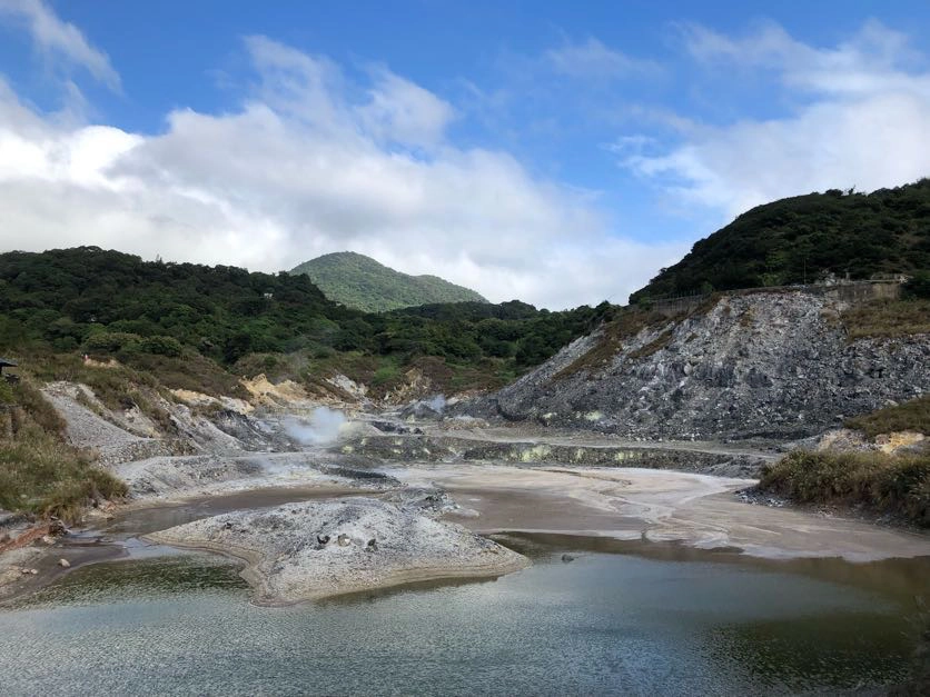
Fumaroles (gas vents) and sulphur deposits (yellow patches) at Sulphur Springs Valley, Yangmingshan National Park. © John Bloomfield.
A local treat, perhaps after a walk along one of the excellent hiking trails through the Yangmingshan National Park or just as a Sunday afternoon social with extended family or friends, is to go to the Sulphur Springs Valley ‘Feet Pool’. Here there are a series of circular, open-air, communal ponds, each a little bigger than a child’s paddling pool, where you can sit on low stone walls dangling your legs and feet into the geothermal waters. These are toe-curlingly hot, with the coolest pool at about 40°C, but once you’re in it’s a wonderfully relaxing and convivial experience.
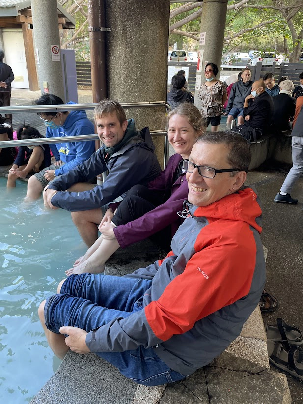
Three of the BGS team sampling the delights of the Sulphur Springs Valley Feet Pool after a day visiting the volcanic landscapes and geothermal features of the Yangmingshan National Park. © Ya Sin Yang.
Water and groundwater in Taiwan
Taiwan has a tropical to subtropical monsoon climate. Average rainfall is around 2.5 m per year (about two and a half times the global average) but, in the Central Mountain Range, annual rainfall totals can locally reach 3 m per year. Most rain falls in the monsoon season between May and October: in the south, this accounts for about 90 per cent of the annual precipitation but is only about 60 per cent in the north of the island.
Typhoons are most frequent between July and October, with four direct landfalls a year on average. Rainfall can be intense during typhoons, with rates of greater than 100 mm per hour regularly recorded. Taiwan’s catchments are some of the steepest in the world; when combined with typhoon rainfall, this means that the catchments also transport vast amounts of alluvium to the coast. Erosion rates of 3 to 7 mm per year lead to hundreds of millions of tons of sediment being swept through the catchments each year. It has been estimated that Taiwan contributes about two per cent of the annual global sediment flux.
About 25 per cent of the rainfall in Taiwan (approximately 88 billion m3) is lost to evaporation; about 70 per cent feeds surface runoff and the remaining 5 per cent (about 4 billion m3) is recharged to groundwater. However, because most of the surface runoff is lost by direct drainage to the sea, 42 per cent of the total water used in Taiwan annually (18.1 billion m3) comes from surface water flows, 35 per cent from groundwater and 23 per cent from reservoir storage. The surface water runoff is highly seasonal and, even at the start of the dry season, many of the rivers will have ceased to flow, meaning that the country is reliant on groundwater and water from reservoirs for much of the year.
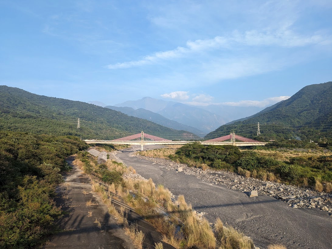
Kaoping River in Pingtung County, with the foothills of the central highlands in the background. The Kaoping River has the largest drainage area of any river in Taiwan and a mean flow of 268 m3 per second. Even at the start of the of the dry season in mid-November, there was no surface flow. © Jon Mackay.
Taiwan’s irrigated agricultural production is predominantly fed by groundwater abstracted from the alluvial aquifers of the western coastal plain, whilst public water supply and water for Taiwan’s high-tech sector are primarily dependent on surface flows and from reservoirs on the western flanks of the central mountains. Over the last few decades, unsustainable groundwater abstraction for irrigation has locally led to subsidence, with negative effects on built infrastructure and increased coastal flood risk.
There has been an increased drive to provide resilient water supplies for industry since a major drought in 2021, when there was a failure of the monsoon that resulted in restrictions in water for industrial and other uses. This made global headlines as it threatened semi-conductor production. Taiwan is one of the most globally significant producers of semi-conductor chips and up to 8 l of ultra-pure water are used to wash each square centimetre area of chip during manufacture.
Novel water management schemes
On a visit to the Tainan Hydraulic Laboratory (THL) at NCKU, we heard how multiple approaches are being used to improve the resilience of the water environment and to manage subsidence associated with overabstraction of groundwater. These include:
- decreasing groundwater abstraction through improved agricultural efficiency and pumping-well management
- land-use zoning and regulation of abstractions near major national infrastructure, such as along the route of the national high-speed rail line
- measurement of variable subsidence with depth using an array of combined groundwater level and novel, multi-layer compaction monitoring boreholes across the western alluvial aquifer
Whilst at the THL, BGS’s Chris Jackson and Jon Mackay presented some of the innovative approaches used by our environmental modelling team to address water resource management issues in the UK.
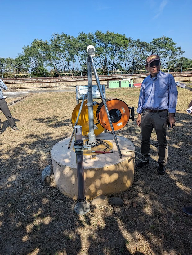
Demonstration of one of the novel, multi-layer compaction monitoring boreholes at Tainan Hydraulic Laboratory, HCKU. © Jon Mackay.
We also visited three engineering schemes in the Kaoping River catchment in Pingtung County in Southern Taiwan. The first scheme, the Err-fon Irrigation Scheme, consists of a subhorizontal collector well emplaced in the hyporheic zone (the underground zone where surface water and groundwater mix) of the Kaoping River as it the emerges from the foothills of the Central Mountain Range. The collector well is based on a similar construction built at the same site over 100 years ago:
- one in one hundred slope
- triangular section
- just over 2 m tall
- about 300 m long
Even though the river regularly dries out in the dry season, groundwater from the hyporheic zone provides year-round flow to the local irrigators. It also has significantly reduced turbidity compared to the river’s surface water.
We then visited the Great Chaozhou Artificial Lake. This is a large, 300 hectare, managed aquifer-recharge scheme. It takes water from the Kaoping River during the wet season (at a rate of about 115 m3 per second) and delivers it to a series of ponds and a wetland for wildlife. The first two ponds act as sediment traps whilst the third pond is for groundwater recharge. It is estimated that the scheme currently provides annual recharge to groundwater of 146m3 a year.
The alluvial plain below the scheme is an area of groundwater overabstraction and land subsidence and is consequently increasingly susceptible to coastal flooding. The scheme addresses the issues of both groundwater overabstraction and coastal flooding.
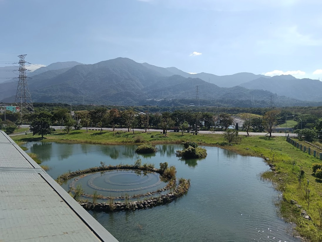
Wildlife wetland at the Great Chaozhou Artificial Lake managed groundwater recharge scheme in Pingtung County. One of the sediment settlement ponds can be seen behind the road in the mid-distance and, in the far distance, the foothills of the Central Mountain Range, where the water intake for the scheme is located on the Kaoping River. © Kathryn Leeming.
Finally, we visited a large radial collector well scheme lower in the Kaoping River catchment. Again, this large, modern facility was emplaced in the hyporheic zone of the river bed and is capable of supplying groundwater to about 10 000 people year round, even when the surface flows had ceased.
A radial collector well in to the hyporheic zone of the Kaoping River behind a 5 m-high flooding bund. © Jon Mackay.
Make time for food and conversation
One of the joys and privileges of spending time with colleagues from other institutions in their home countries is being introduced to their cuisine and having time for considered conversations, rather than the quickly grabbed snacks and brief discussions that are common in our normal day-to-day working lives. In Taiwan, this was no exception and our NCKU hosts generously provided ample opportunity to try Taiwanese food. A few of the highlights for the BGS team included:
- street food at one of Tainan’s many night markets
- deep fried prawns with brown sugar sauce, hundreds and thousands and a glace cherry (yes it does work!)
- grouper in a rich soy gravy
- Oolong tea from the high mountains
The Pinglin Tea Museum, New Taipei City, was informative and insightful, providing lots of interesting information on how tea is grown and made in Taiwan, explaining the cultural importance of tea to the Taiwanese, and celebrating it with an amazing collection of fine tea sets and tea-related paraphernalia.
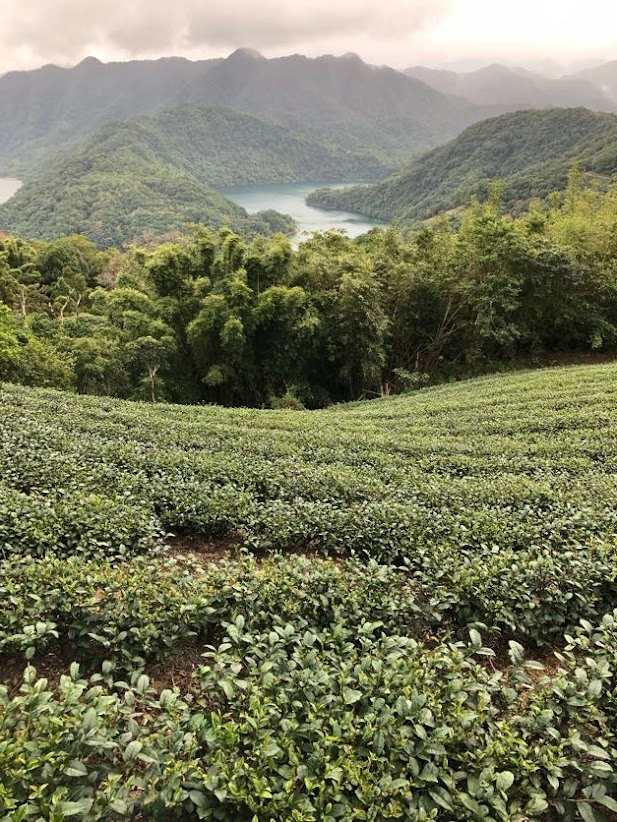
Tea plantation, Pinglin District, New Taipei City. © John Bloomfield.
One of the glazed and highly valued teacups on display at the Pinglin Tea Museum, New Taipei City. © John Bloomfield.
The challenge of a changing environment and research opportunities
As well as the field trips and introductions to the wider work of the NCKU team, we continued to work on our three core activity areas while we were in Taiwan:
- analysis of groundwater drought in Taiwan
- the first analysis of the delayed flow spectrum using stream flow data from both Taiwan and the UK
- development of the first groundwater forecasts for Taiwan
As previously mentioned, the drought of 2021 in Taiwan highlighted the need to better understand droughts in general and groundwater drought in particular at a national scale across Taiwan. The NCKU-BGS team are using the standardised groundwater level index (SGI), previously developed by BGS, in combination with a range of statistical techniques to characterise the recent spatio-temporal distribution of groundwater droughts in Taiwan to better understand controls on drought formation and propagation.
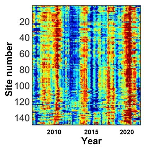
Heat map showing the status of groundwater levels (as SGI) at about 150 observation boreholes across Taiwan between 2008 and 2022. Blue represents relatively high groundwater levels and red relatively low groundwater levels associated with drought. The major drought in 2021 associated with the missing monsoon season that year is clearly evident in the groundwater level data. © Ben Marchant.
Understanding the baseflow of rivers — the flow contributed by the catchment rather than direct flow generated from rainfall — is central to the effective management of water resources in semi-permeable and permeable catchments. Baseflow is delivered to rivers over a wide range of timescales; however, to date it has typically been characterised over a fixed, relatively short time window (successive five-day periods). BGS has recently developed a new technique to analyse baseflow over a much wider range of time periods, potentially giving a fuller understanding of the phenomenon. This new method is being applied to stream-flow data from both the UK and Taiwan to test its applicability over the widest range of flow regimes, catchment characteristics and driving climatologies.
Finally, for a number of years, BGS has provided a service of seasonal forecasts of groundwater levels. Working with our partners at NCKU, we are trialling the approach for the first time in a monsoonal setting and working with them to develop the first groundwater forecasts for Taiwan.
Thank you to our partners at NCKU
We would like to thank all our colleagues at NCKU for such a stimulating and interesting visit. In particular, many thanks go to Prof Yeh for arranging the itinerary so thoughtfully, to Prof Hsu and Prof Chen for thought-provoking conversations and their hospitality, and to Dr Huang, Dr Yang and Dr Peter Chen for their company in escorting us throughout our stay in Taiwan.
Contact
If you would like to know more about the ‘Groundwater resources under change in Taiwan and in the UK’ project, please contact BGS Hydrogeology
Further reading
Bloomfield, J P, Gong, M, Marchant, B P, Coxon, G, and Addor, N. 2021. How is baseflow index (BFI) impacted by water resource management practices? Hydrology and Earth System Sciences, Vol. 25(10), 5355–5379. DOI: https://doi.org/10.5194/hess-25-5355-2021
Chen, H-Y, Hsu, Y-H, Huang, C-C, and Yeh, H-F. 2023. Baseflow variation in southern Taiwan basin. Sustainability, Vol. 15(4), 3600. DOI: https://doi.org/10.3390/su15043600
Marchant, B P, Cuba, D, Brauns, B, and Bloomfield, J P. 2022. Temporal interpolation of groundwater level hydrographs for regional drought analysis using mixed models. Hydrogeology Journal, Vol. 30, 1801–1817. DOI: https://doi.org/10.1007/s10040-022-02528-y
Tanguy, M, Chevuturi, A, Marchant, B P, Mackay, J, Parry, S, and Hannaford, J. 2023. How will climate change affect spatial coherence of streamflow and groundwater droughts in Great Britain? Environmental Research Letters, Vol. 18(6), 064048. DOI: https://doi.org/10.1088/1748-9326/acd655
Yeh, H-F. 2021. Spatiotemporal variation of the meteorological and groundwater droughts in central Taiwan. Frontiers Water, Vol. 3, 636792. DOI: https://doi.org/10.3389/frwa.2021.636792
Relative topics
Latest blogs

Building Europe’s geological future
20/07/2026
BGS scientists are contributing to a continent-wide initiative that is strengthening collaboration across borders to tackle shared subsurface challenges and unlock new opportunities.

Collecting beach pebbles: fun hobby but is it legal?
14/07/2026
The UK coastline will be inundated with keen holidaymakers this summer, many of whom will take a memento of their trip home in the shape of a pebble or two — but is it legal?

Strengthening capacity through partnership: a critical minerals perspective
28/04/2026
BGS has been working in partnership with the Geological Survey Department of Zambia (GSD) to build national capacity, improve data accessibility and support long-term, sustainable development.

PhD adventures in Copenhagen, Denmark: revealing past recovery processes of tropical forest systems through ancient environmental DNA
12/03/2026
PhD student Chris Bengt visited the University of Copenhagen to carry out very delicate extraction of aeDNA from lake-sediment cores, in the hopes of unlocking the secrets of past volcanic eruptions.

MARC Conference 2025: highlighting the importance of conferences to PhD students
16/02/2026
BGS and University of Nottingham PhD student Paulina Baranowska shares her experience presenting her research on nuclear forensics at her first international conference.

Hole-y c*@p! How bat excrement is sculpting Borneo’s hidden caves
23/12/2025
BGS researchers have delved into Borneo’s underworld to learn more about how guano deposited by bats and cave-dwelling birds is shaping the subsurface.

How the geology on our doorstep can help inform offshore infrastructure design
19/11/2025
BGS is part of a new collaboration using onshore field work to contextualise offshore data and update baseline geological models which can inform the sustainable use of marine resources.

Fieldwork on Volcán de Fuego
13/10/2025
Understanding how one of the world’s most active volcanoes builds up material, and how they collapse to feed hot flows
Esthwaite Water: applying novel approaches to understand lake-water nutrient pollution
19/09/2025
Andi Smith (BGS) and Savannah Worne (Loughborough University) embarked on fieldwork in the Lake District, applying a novel stable isotope method for tracing phosphorus sources.

Opening up the geosciences: making work experience more accessible
19/09/2025
BGS has been working with partners to make the geosciences more accessible to young people, including those from under-represented backgrounds.
PhD adventures in the Philippines: coring around Lake Bulusan
05/09/2025
Chris Bengt recounts his two-week field trip to Bulusan Volcano Natural Park in the Philippines to collect lake sediment cores, fresh soil and water samples.
Gemini: a new stable isotope tool
21/08/2025
BGS’s Stable Isotope Facility has new mass spectrometer equipment for analysing carbon and oxygen isotopes from carbonates and water.