New method developed to identify wetland inhabitants
BGS-led research has helped develop a method to identify ancient human and animal wetland inhabitants.
01/11/2023 By BGS Press

A team of isotope scientists from BGS, along with Cardiff University, has led research that has developed a new analytical method to identify archaeological remains of humans and animals that once inhabited wetlands. The method provides an additional tool for archaeologists to explore human and animal mobility in the past.
Identifying human and animal movement has long been an important pursuit in archaeology. Isotope analysis provides direct data for this and is helpful in identifying non-local individuals and patterns of migration.

Our aim was to test the hypothesis that certain underlying rock types will produce low sulphur (sulfur; S) isotope values, which are transferred through the food chain and could therefore provide a means of identifying humans and animals raised in wetlands in the past.
Angela Lamb, BGS Isotope Geochemist.
The new research explored the potential of previously undiagnostic low, often negative, S-isotope values to identify wetland dwellers. This was carried out by testing the hypothesis that impervious clays, which often support wetlands, will produce low S-isotope values due to both the underlying substrate and redox conditions.
Collecting samples
To characterise the modern S-isotope biogeography of typical wetland environments, the researchers collected and analysed 58 modern plant samples taken from areas overlying Jurassic rocks in southern England. The sampling targeted archaeologically important areas of the Somerset Levels and the Cambridgeshire Fens. S-isotope ratios were also extracted from the bone collagen of 65 faunal fossil samples from archaeological sites in both regions and analysed to compare with modern data and test if this relationship held for archaeological samples. To understand if the plant signals were transferred up the food chain to the fauna, S-isotopes in modern bone collagen, extracted from nine farm animals raised in these areas, were also analysed.
An additional tool for archaeologists
Of the samples tested, 60 per cent gave a value below zero, with the modern plant datasets giving more negative values for the eastern regions of Cambridgeshire relative to Oxfordshire and Somerset. The plants showed a correlation between S-isotope composition and altitude, which supports the idea that low-lying wetlands supply the most negative values into the environment.
These results support the interpretation that relatively low or negative S-isotope values are indicative of vegetation and wildlife growing and grazing on wetland regions underlain by Jurassic clays. Data from this study formed part of a new BGS isotope domain map (see Figure 1).
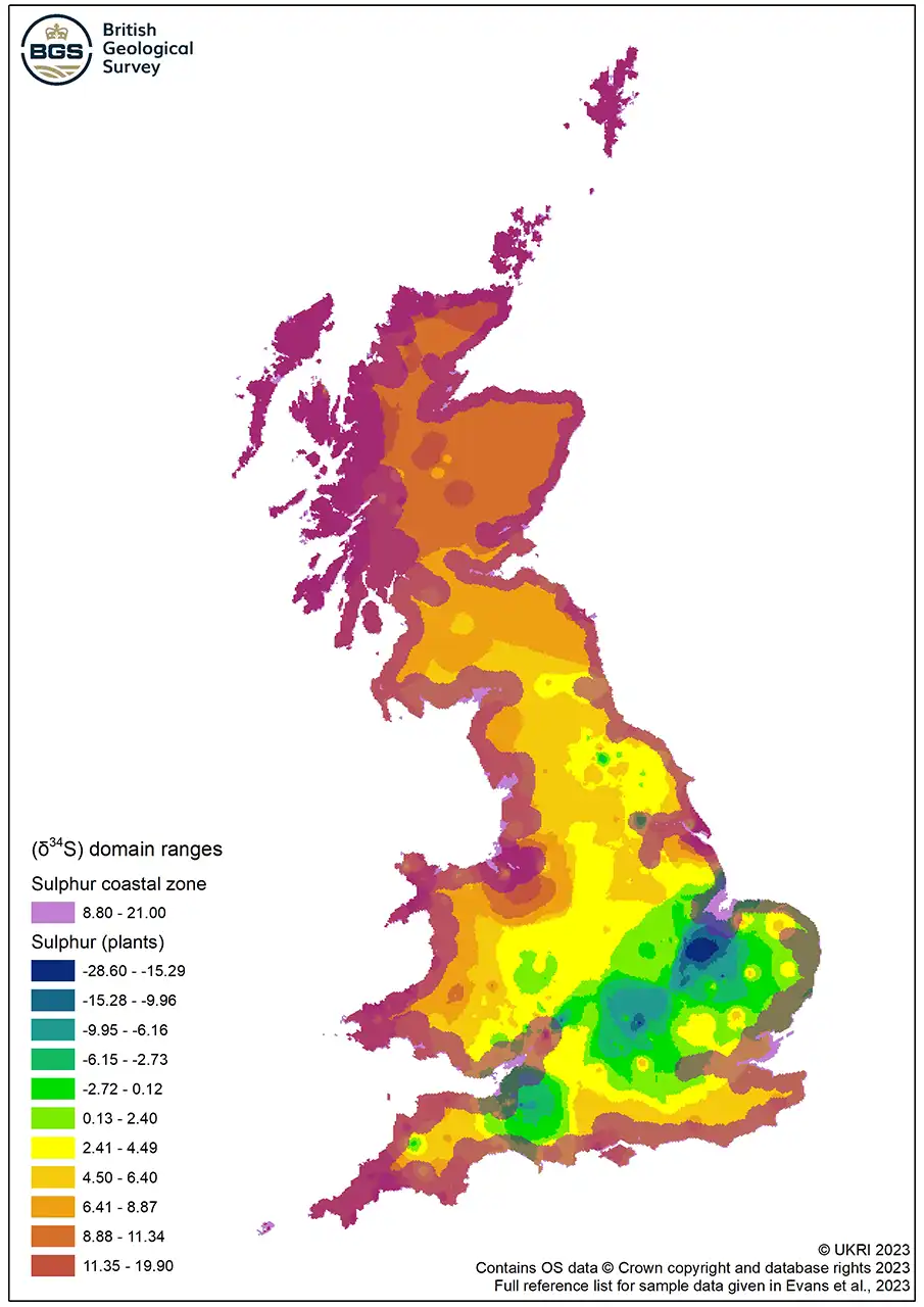
Figure 1 Map of S-isotope domain ranges for plants. BGS © UKRI.
Further work is needed to resolve regional differences in the altitude below which low S-isotope values occur and to understand S-isotope variability in higher altitude locations on the Jurassic clay, but this is a step forward in our understanding and therefore the application of low S- isotope ratios.
Angela Lamb
As a result, ancient humans and animals from wetlands, or that acquired their food from wetlands, may be identified using primary analytical methods. This provides an additional tool for archaeologists to explore animal management and human and animal mobility in the past.
More information
Read the research: Wet Feet: developing sulfur isotope provenance methods to identify wetland inhabitants
Evans, J A, Chenery, C A, Mee, K, and Marchant A P. 2023. Biosphere Isotope Domains GB (V2) [interactive website]. Available at https://www.bgs.ac.uk/datasets/biosphere-isotope-domains-gb/
Relative topics
Related news

UK and Philippines scientists investigate natural hydrogen generation processes at atomic scale
22/06/2026
BGS researchers were granted access to use the Diamond Light Source facility in order to study hydrogen in light brighter than the sun.

Shortage of end-of-life materials presents challenge to UK critical minerals security
17/06/2026
A new report by the UK Critical Minerals Intelligence Centre reveals insufficient end-of-life material stocks present a supply risk over the coming decade, but offer significant long-term potential to meet critical mineral demand through recycling.

UK geothermal catalogue receives update
16/06/2026
BGS releases the second digital version of the UK geothermal catalogue of subsurface temperature and rock thermal conductivity measurements and heat flow calculations.

Scientists make new discovery in the history of the Giant’s Causeway
15/06/2026
New research is changing our scientific understanding of the formation of one of the UK’s most iconic landmarks and has revealed that Northern Ireland’s volcanic past occurred over a much shorter period than previously thought.

Latest research emphasises climate-related subsidence risk to millions of British homes
11/06/2026
New data from BGS highlights the projected future impact of warmer, drier summers and underlines the need for mitigation measures in susceptible regions.

Ukraine and the UK strengthen their commitment to geological cooperation
10/06/2026
A new Memorandum of Understanding reaffirms the UK’s support of Ukraine’s ambitions to develop its critical mineral resources, paving the way for collaboration through capacity-building programmes.
Newly released core could hold clues on potential mineral prospectivity in Perthshire
05/06/2026
A comprehensive collection of geological samples from the vicinity of a former mine in Scotland is now available to scientists for further research.

Extractive Industry Geology (EIG) Conference 2026
Event from 08/09/2026 to 11/09/2026
University of Liverpool
Latest data on world mineral production now available
25/05/2026
BGS has released the updated statistics on the global production of over 70 commodities between 2020 and 2024.

International science consortium to survey the health, economic value and social importance of Lake Victoria
22/05/2026
The project will replicate the 1927 survey to assess changes in the lake’s health, economic value and social importance.

New geological maps of Berwick-upon-Tweed to help future-proof natural water supply
20/05/2026
Scientists have mapped the geology under the town to better understand the groundwater system to inform decisions around abstraction.