UK’s geomagnetic blind spots tackled with new observatories
Three new geomagnetic observatories have been installed across the UK to fill in the country’s 'blind spots' and tackle the risk posed by space weather.
28/07/2022 By BGS Press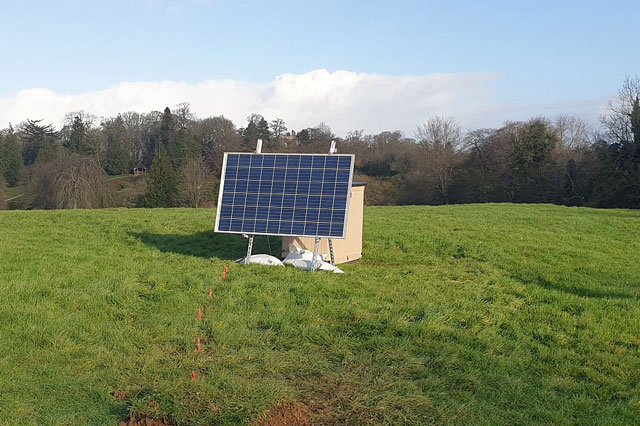

Three new underground geomagnetic observatories in County Fermanagh, Leicestershire and Sussex will detect and eventually help predict space weather, which can potentially disrupt power grids, satellite communications and the GPS on smartphones.
They were installed underground in quiet, rural locations by the BGS Geomagnetism team. The solar-powered observatories will collect data about Earth’s natural magnetic field and send it back to BGS in real-time, using the mobile phone network.
Why do we need new geomagnetic observatories?
Intense geomagnetic storms can have an adverse impact on technology like
power systems, satellite operations and smartphones.

The new magnetometers mean we now have full coverage of magnetic field change across the UK.
Very large geomagnetic storms produce widespread aurora. While beautiful, they have the potential to be incredibly disruptive.
They could cause power disruption and affect essential services like satellite communications and transport.
Now that we have monitors in our blind spots, we will better understand in detail where and what ground effects can occur and understand why they happened.
Dr Ciarán Beggan, BGS Geophysicist.
Britain has had geomagnetic observatories in Shetland, Eskdalemuir and
Devon since 1908, covering the country from north to south; the three new observatories will improve the breadth of measurements from west to east.
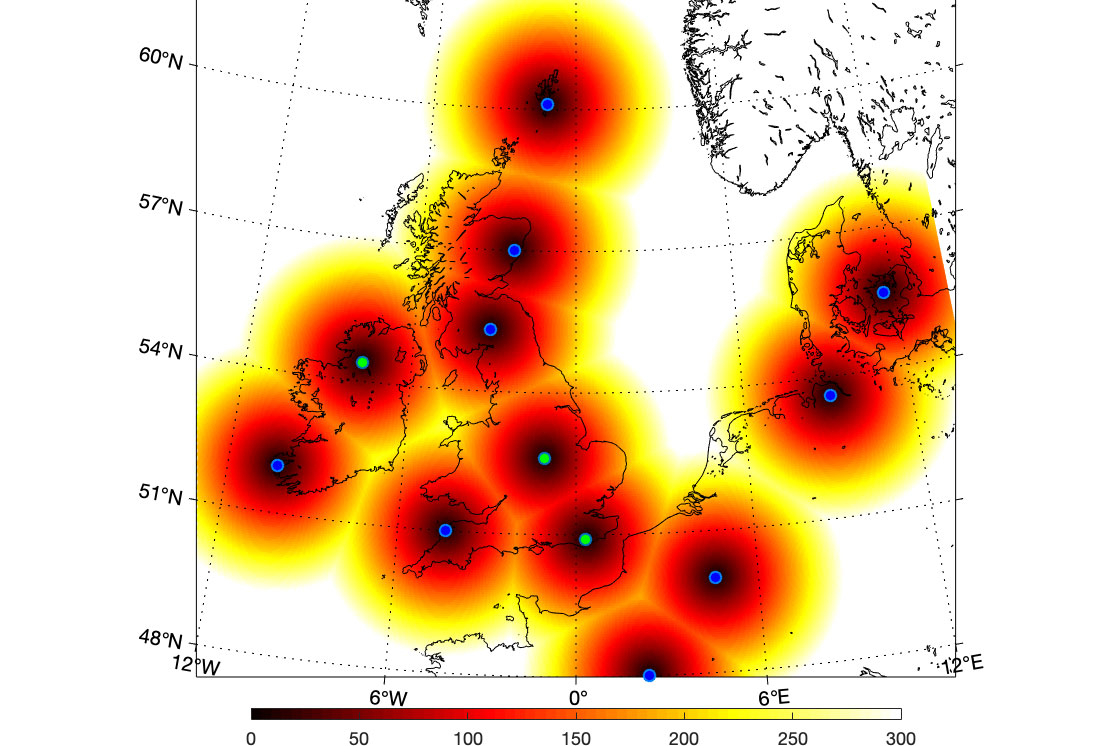
Zones of influence for the geomagnetic observatories.
The blue dots are existing observatories in the UK, Ireland and in northern Europe. The green dots are new UK observatories, three of which BGS installed in the past six months. The graded colouring from red to yellow shows the distance away from each location (up to 300 km away). No UK observatory is more than about 350 km (yellow colour) from its nearest neighbour and every part of the UK is within 200 km of an observatory.
The Aberdeen observatory is operated by Lancaster AuroraWatch, not BGS.
BGS © UKRI.
Mitigating a national risk
Severe space weather was included in the UK Government’s National Risk Register 2020.
Geomagnetic storms are one form of space weather. They interrupt essential
services by creating geoelectric fields in the subsurface, which then flow
into transformers, pipelines and railways, causing malfunctions.
Other effects include an increase in the density of the upper atmosphere (ionosphere), which disrupts radio waves passing through it. This leads to a loss of signal between the ground and satellites, affecting communications and the accuracy of global navigation satellite systems (GNSS). A huge number of technology systems rely on GNSS, including:
- phones
- trains
- self-driving vehicles
- timing for internet transactions
Major geomagnetic storms are relatively rare but, as Dr Beggan points out, they
have a pattern.
Major geomagnetic storms happen every 30 or 40 years in the UK, but we haven’t had a big one since 1989.
We live in a completely different society now, where we are all reliant on
continuous electricity supplies, smartphones and satellite communications — a major geomagnetic storm could significantly reduce those services.We’re currently moving into a stronger part of the solar cycle, which means the chance of large geomagnetic storms is greater.
Geomagnetic storms are currently hard to predict in terms of size or even arrival time from the Sun. Adding the new sensors means we are able to measure their effects on the ground in real-time and advise on the impact on technology.
Dr Ciarán Beggan, BGS Geophysicist.
Further reading
- Find out more about geomagnetism from BGS
Funding
The geomagnetic observatories were funded by UK Research and Innovation’s £20 million Space weather innovation, measurement, modelling and risk (SWIMMR) programme.
Relative topics
Media contact: Sarah McDaid (sarah@mcdaidpr.co.uk 07866789688)
How were the new sites selected?
Ciarán Beggan said: ‘We need a magnetically quiet, secure site. A magnetically quiet site must be at least 250 m from buildings, power lines and electric fences and 5 km from an electrified train line.
‘Ideally, it will have a south-facing aspect for the solar panel and 1 m of soil to allow the sensor to be buried. We ask permission from the landowner prior to installation. We want locations that are around 200–250 km from the existing observatories as this is the general “scale” of magnetic field changes during geomagnetic storms.
‘Fermanagh is the most westerly part of Northern Ireland. The Sussex site is relatively easterly and is part of an existing BGS facility at Herstmonceux. The Leicestershire site is approximately in the middle of England, equidistant between the observatories in Devon and Eskdalemuir.’
Examples of geomagnetic storms having adverse impact:
- 2022: Elon Musk’s SpaceX lost 40 satellites in one day as the result of a geomagnetic storm
- 2003: power outage in Sweden caused by geomagnetic storm
- 1989: Quebec 12-hour blackout caused by geomagnetic storm
- 1859: the ‘Carrington storm’, the biggest ever geomagnetic storm recorded, when people could see the northern lights in the tropics
- What if the Carrington storm happened today, in the satellite comms and smartphone era?
Related news

Updated geological assessment of the Southern North Sea set to underpin future offshore infrastructure development
25/03/2026
The first regional assessment for 30 years will support offshore marine and subsurface planning for the UK’s low-carbon energy infrastructure, including the 2030 target of 45 to 50 GW generated through offshore wind.

New research could help provide a more reliable water supply for millions in rural Africa
24/03/2026
A new BGS-led study has revealed crucial insights into the longstanding challenges affecting the reliability and performance of rural water supply infrastructure in sub-Saharan Africa.

Call for new members and Chair to join the NERC facilities steering committees
25/02/2026
New members are needed to join the committees over the next four years.

Your views wanted: developing a geothermal energy subsurface data portfolio
24/02/2026
BGS is aiming to support the growth of the sector by providing the best-available, location-specific geothermal and ground source heat information as an accessible product or service.

Map of BGS BritPits showing the distribution of worked mineral commodities across the country
18/02/2026
BGS’s data scientists have generated a summary map of the most commonly extracted mineral commodities by local authority area, demonstrating the diverse nature of British mineral resources.

Funding awarded to map the stocks and flows of technology metals in everyday electronic devices
12/02/2026
A new BGS project has been awarded Circular Electricals funding from Material Focus to investigate the use of technology metals in everyday electrical items.

New UK/Chile partnership prioritises sustainable practices around critical raw materials
09/02/2026
BGS and Chile’s Servicio Nacional de Geología y Minería have signed a bilateral scientific partnership to support research into critical raw materials and sustainable practices.

Extensive freshened water confirmed beneath the ocean floor off the coast of New England for the first time
09/02/2026
BGS is part of the international team that has discovered the first detailed evidence of long-suspected, hidden, freshwater aquifers.

Funding secured to help mitigate ground risk in UK construction sector
05/02/2026
The BGS Common Ground project has been awarded new funding to help unlock the value of ground investigation data.

Can sandstones under the North Sea unlock the UK’s carbon storage potential?
02/02/2026
For the UK to reach its ambitious target of storing 170 million tonnes of carbon dioxide per year by 2050, it will need to look beyond the current well-studied geographical areas.

Quaternary UK offshore data digitised for the first time
21/01/2026
The offshore wind industry will be boosted by the digitisation of a dataset showing the Quaternary geology at the seabed and the UK’s shallow subsurface.

Suite of ten new soil reference materials released
02/01/2026
BGS has a longstanding track record of producing high-quality reference materials and has released ten new soil reference materials.