Updated geological assessment of the Southern North Sea set to underpin future offshore infrastructure development
The first regional assessment for 30 years will support offshore marine and subsurface planning for the UK’s low-carbon energy infrastructure, including the 2030 target of 45 to 50 GW generated through offshore wind.
25/03/2026 By BGS Press

The British Geological Survey (BGS) has released a new shallow subsurface geological synthesis of the southern North Sea in the first formal review of this region since the 1990s. A wealth of new subsurface data has been generated through the rapid expansion of offshore wind farm (OWF) development since the last assessment.
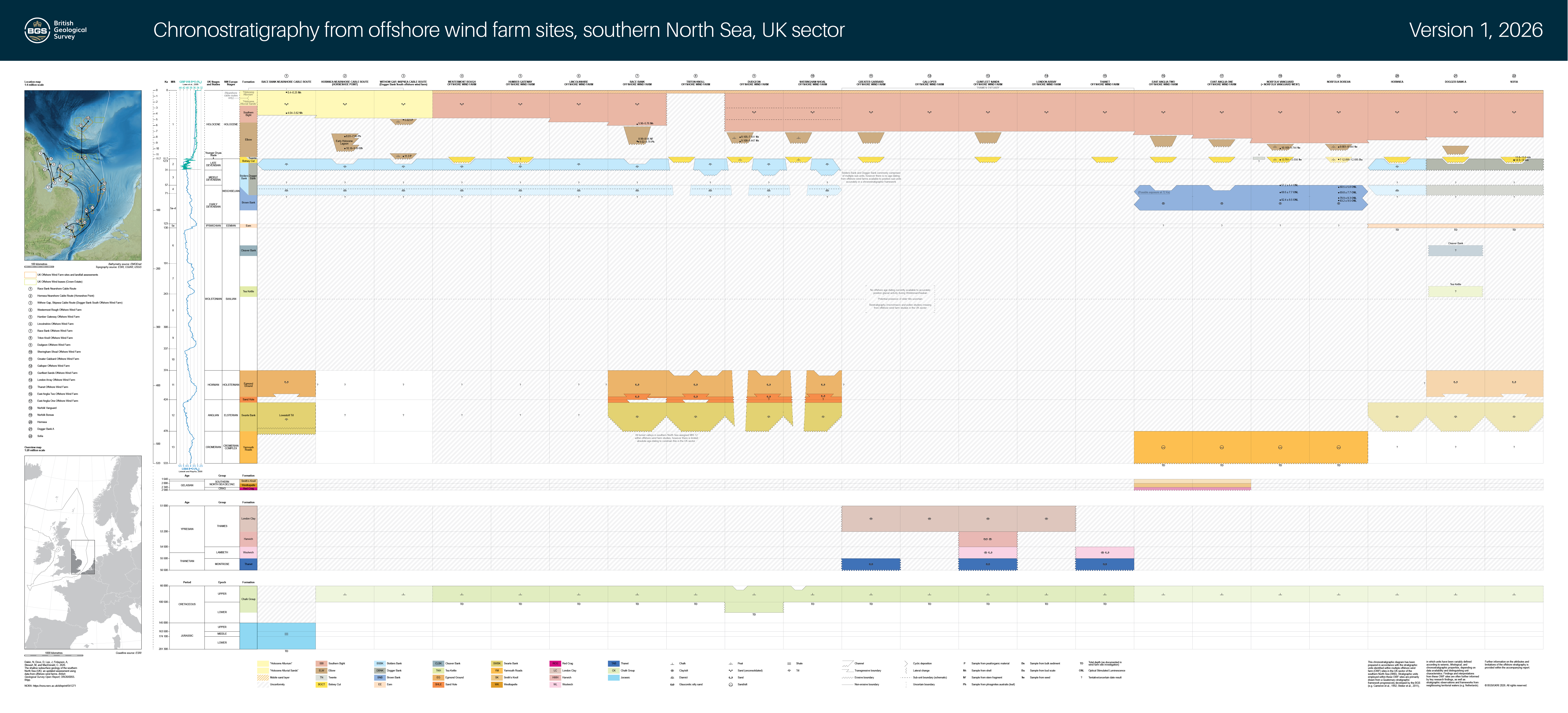
Presence and age of different geological formations beneath OWF sites in the southern North Sea. BGS © UKRI 2026.
In total, the new synthesis draws on data from 22 OWFs and cable landfall sites from recent publications and open data available through The Crown Estate’s Marine Data Exchange. Bringing these diverse datasets together presented a rare opportunity to enhance our geological understanding of the region, providing a detailed baseline resource to support more efficient and better-informed offshore development projects in the future.

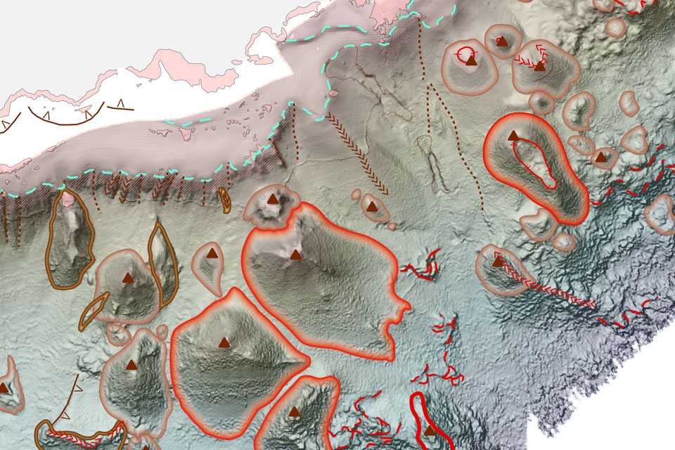
Offshore bathymetry map of the southern North Sea (EMODnet, 2024). Onshore digital elevation model (DEM) from SRTM, GTopo30, GEBCO (Tozer et al., 2019). MIS 2 ice sheet limit (merged) from Clark et al. (2022b). MIS 12 onshore ice sheet limit from Lee and Roberson (2025). Southern North Sea (SNS) area of interest from Charting Progress 2 Reporting Regions (JNCC, 2025). BGS © UKRI 2026.
Findings from the updated review have revealed much greater geological complexity within the region than indicated by the previous assessment, which was developed between the 1970s and 1990s on the back of data collected during oil and gas developments. Modern OWF investigations, supported by comprehensive borehole drilling, cone penetration tests and seismic datasets, show that many of the geological formations contain a variety of distinct sedimentary characteristics. This complexity has direct implications for foundation design and ground modelling, including the identification of geo-engineering constraints and geohazards, which is crucial information for a wide range of offshore infrastructure development.

(A) Semi-transparent offshore bathymetry map (EMODnet, 2024) overlain by status of OWF leases and cable route corridors. Infrastructure status information from The Crown Estate (2025). (B) Offshore bathymetry map (EMODnet, 2024) overlain by OWF leases and cable route corridors (orange dots indicate landfall areas) collated in this study. Onshore DEM from SRTM, GTopo30, GEBCO (Tozer et al., 2019). SNS offshore area outline from Charting Progress 2 Reporting Regions (JNCC, 2025). BGS © UKRI 2026.
The assessment examined evidence across pre-glacial, glacial, interglacial and post‑glacial periods from 200 million years ago to the present day. Understanding how different sedimentary units were deposited provides vital insight into geological formations that may present specific geo-engineering complications. This includes mixed soils, boulders, glacially compacted sediments or organic-rich layers. Organic units can be problematic for cable installation due to their fibrous nature, presenting considerable challenges to cable routing.
It is not a requirement for UK offshore infrastructure projects to collect samples for dating and biostratigraphy; however, where they are available, absolute dating (radiocarbon and optical stimulated luminescence data) information has also been included within the assessment. Neighbouring countries such as the Netherlands recognise the value of this data, as it can help to better predict age-based sedimentary characteristics and ultimately better inform geotechnical characterisation around a project’s design.
The report outlines several recommendations to enhance the resource further, including improving fine-scale mapping, ingesting geotechnical datasets for each geological subunit and strengthening international collaboration to harmonise North Sea stratigraphy. The findings presented in the main report can be aligned with results presented in the Geo‑Assessment Matrix, which is a data catalogue highlighting the key geological features and associated engineering constraints for OWF development as part of the Geological Service for Europe. Both resources provide complementary datasets and criteria essential for evaluating OWF site suitability.
This work provides:
- an opportunity to advance scientific understanding
- resources to strengthen national collaboration
- supporting baseline evidence for the energy transition, energy security and wider marine planning

The release of this report marks an important milestone in compiling geological observations from literature and offshore wind farm development over the past 30 years or so. It brings together a wealth of new offshore geological data that enhances our understanding of the shallow subsurface in the marine environment in the southern North Sea. We hope this dataset will provide strong baseline evidence to support national and international collaboration for efficient offshore development and act as a blueprint for other areas around the UK Continental Shelf.
Nikki Dakin, BGS Senior Marine Geoscientist
We would encourage similar consolidation of geological information across the wider North Sea, Celtic Sea, Irish Sea, The Solent and English Channel, making full use of the substantial dataset holdings within the Marine Data Exchange. There is also significant potential to extend this approach internationally, working with neighbouring countries.
Such data provides a robust evidence base for industry, regulators and researchers, marking an important step toward a fully modernised geological model and improving our understanding of offshore stratigraphy across the UK Continental Shelf.
The report and geological assessment are now available online: The shallow subsurface geology of the southern North Sea (UK): an updated assessment using data from offshore wind farms.
BGS would like to acknowledge The Crown Estate as well as wind farm developers for contributing reports and data to The Crown Estate’s Marine Data Exchange.
Relative topics
Related news
Updated geological assessment of the Southern North Sea set to underpin future offshore infrastructure development
25/03/2026
The first regional assessment for 30 years will support offshore marine and subsurface planning for the UK’s low-carbon energy infrastructure, including the 2030 target of 45 to 50 GW generated through offshore wind.

Extensive freshened water confirmed beneath the ocean floor off the coast of New England for the first time
09/02/2026
BGS is part of the international team that has discovered the first detailed evidence of long-suspected, hidden, freshwater aquifers.

Quaternary UK offshore data digitised for the first time
21/01/2026
The offshore wind industry will be boosted by the digitisation of a dataset showing the Quaternary geology at the seabed and the UK’s shallow subsurface.

How the geology on our doorstep can help inform offshore infrastructure design
19/11/2025
BGS is part of a new collaboration using onshore field work to contextualise offshore data and update baseline geological models which can inform the sustainable use of marine resources.

Extended seabed geology map of the Bristol Channel published
07/10/2025
BGS has released significantly extended high-resolution maps that will support offshore green-energy initiatives in the area.

New seabed sediment maps reveal what lies beneath the waves
03/09/2025
Marine ecosystem science and offshore infrastructure will be boosted by a new dataset showing sediment composition across the UK continental shelf.

IODP³-NSF Expedition 501: successful offshore operations launches onshore phase
06/08/2025
Scientists have managed to take water and sediment samples from beneath the ocean on the New England Shelf for the first time, with the intention of understanding this offshore aquifer system.
BGS scientists join international expedition off the coast of New England
20/05/2025
Latest IODP research project investigates freshened water under the ocean floor.
New seabed geology maps to enable long term conservation around Ascension Island
01/04/2025
BGS deliver the first marine geology and habitat maps for one of the world’s largest marine protected areas.
New study reveals long-term effects of deep-sea mining and first signs of biological recovery
27/03/2025
BGS geologists were involved in new study revealing the long-term effects of seabed mining tracks, 44 years after deep-sea trials in the Pacific Ocean.
Seabed geology data: results from stakeholder consultation
31/01/2025
BGS collected valuable stakeholder feedback as part of a new Crown Estate-led initiative to improve understanding of national-scale seabed geology requirements.
New hazard maps set to help safeguard UK offshore energy industry
12/09/2024
Essential geological model detailing seismic hazard published as the pursuit of new renewable energy infrastructure intensifies.