Exploring the world beneath your feet
04/02/2019 By BGS Press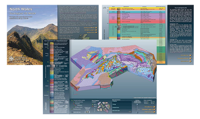

Natural water in the ground below us could be used as a low-carbon heat source in many UK towns and cities, new research from BGS says. The public research body is now calling for more research to understand how geothermal technologies could be scaled up across the UK.
The Earth provides the natural resources that make life in the modern world possible: rocks are used to create buildings, bridges and cars as well as silicon chips, smartphones and jewellery. The underground also stores our waste, supports our infrastructure and absorbs drainage. We rely on it, but it can be hard to imagine what the world below ground actually looks like. The role of the BGS is to ‘shine a light’ into the underground and reveal what lies beneath our feet.
BGS is launching 14 geological visualisation models to provide a unique, 3D view of the structures and geological units that make up the upper 1.5 km of the UK’s crust. Delivered in a pdf format and available to download from the BGS website, the ‘GV models’ bring to life the 3D nature of our Earth by providing an interactive format to enhance conceptual understanding of the UK’s geology.
The GV models allow the user to explore the world below ground in a number of ways — zooming in and out, rotating the view, highlighting different geological sections and querying key information. A detailed legend provides information on each geological unit in the model, such as the age and type of rock, revealing the hidden structure of the underground.
Constructed from the 1:625 000-scale bedrock geology map and the UK3D national fence diagram of cross-sections, the GV models cover England, Wales and Northern Ireland (with models for Scotland planned). They represent a step change in open-access 3D geoscience resources for the UK and complement other regional information resources the BGS delivers, such as the British Regional Geology (Regional Guides) series and the Regional Summaries.

Three-dimensional geology opens up the complex world beneath our feet in a way that can be easily understood. The 3D models may help professionals working in industry and environmental regulation, as well as providing tools for public engagement and teaching. But these open-access tools are there for everyone to explore and discover, whatever your interest in the subsurface.
Dr Katie Whitbread, BGS National Geological Model project manager.
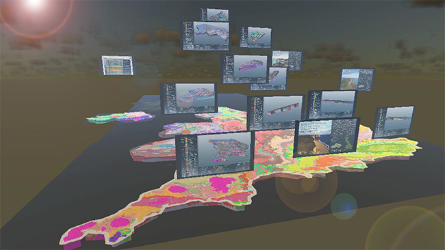
Regional geological visualisation models displayed with the geological model data in GeoVisionary.
The 3D models have been developed under the BGS National Geological Model project, with financial support from Radioactive Waste Management (RWM), and form part of a wider BGS national programme, funded by a range of stakeholders, to make our science publicly available and accessible to all.
To help us enhance the user experience and improve the future development and design of 3D resources, feedback is encouraged and can be submitted through the BGS enquiries service.
- Step-by-step video guide on how to use the models
Relative topics
For further details or to arrange media interviews please contact:
Kirstin Lemon, British Geological Survey Press Office, Belfast, Northern Ireland, BT4 3SB
Office: +44 (0)28 9052 0979 Mobile: +44 (0)7796 931 788
E-mail: klem@bgs.ac.uk Twitter @rokmum
The following are available for interview:
- Dr Katie Whitbread – National Geological Model project manager
For additional information go to:
www.bgs.ac.uk
https://www.bgs.ac.uk/research/ukgeology/nationalGeologicalModel/GVModels.html
Photographs are available from our ftp server: ftp://ftp.bgs.ac.uk/pubload/bgspress
Free for media use with this acknowledgement: British Geological Survey©NERC
British Geological Survey
The British Geological Survey (BGS) is a world leading applied geoscience research centre that is part of UK Research and Innovation (UKRI) and affiliated to the Natural Environment Research Council (NERC). BGS core science provides objective and authoritative geoscientific data, information and knowledge to inform UK Government on the opportunities and challenges of the subsurface. It undertakes national and public good research to understand earth and environmental processes in the UK and globally. The BGS annual budget of approximately £60 million pa is funded directly by UKRI, as well as research grants, government commissions and private sector contracts. Its 650 staff work across the UK with two main sites, the head office in Nottingham and Lyell Centre, a joint collaboration with Heriot Watt University in Edinburgh. BGS works with more than 150 private sector organisations, has close links to 40 universities and sponsors about 100 PhD students each year. Please see www.bgs.ac.uk.