Deep drilling in Europe’s oldest and most species-rich lake provides new insights into evolution
The older and more stable an ecosystem is, the longer lived its species and the more stable the species communities are.
02/10/2020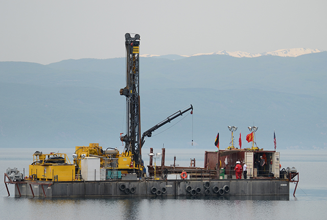

An international research team led by the Justus Liebig University Giessen and the University of Cologne, in collaboration with BGS, gained these new insights into evolution by drilling deep into the sediments of Lake Ohrid.
The 1.4-million-year-old lake on the border between Albania and North Macedonia is not only the oldest lake in Europe, but with more than 300 endemic species, i.e. species that only occur there, it is also the most species rich.
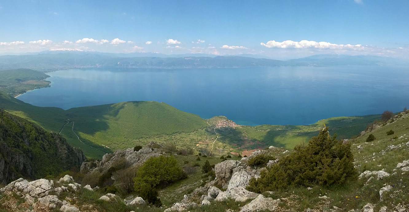
The 1.4 million year old Lake Ohrid on the border between Albania and Northern Macedonia (Photo credit: Thomas Wilke).
To study the evolutionary dynamics of Lake Ohrid since its formation, the scientists combined the environmental and climate data of a 568-meter-long sediment core with the fossil records of over 150 endemic diatom species.
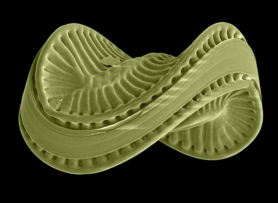
Colorized scanning electron microscope image of the endemic diatom species Scoliodiscus glaber from Lake Ohrid. Size of the silica shell 0.1 mm (Photo credit: Z. Levkov).
Dr Jack Lacey, a geochemist from BGS, used chemical data from the mud to understand past changes in the hydroclimate of Lake Ohrid.

The combination of our data and the fossil diatom record of Lake Ohrid provide us with a link between geological processes, environmental change, and the biological evolution of endemic species within the lake.
Using geochemical data from the layers of mud that built up over time at the bottom of Lake Ohrid, we have unravelled a 1.4-million-year history of lake development and climate change, that are interwoven and captured in the sediment record.
Dr Jack Lacey, BGS Geochemist.
The data show that shortly after the formation of the lake, new species emerged within a few thousand years. Many of them died out again very quickly in the relatively small and shallow lake.
The research team explains this by the fact that young lakes of small size offer many new ecological opportunities, but are also particularly sensitive to environmental changes such as fluctuations in temperature, lake level, and nutrient availability.
The geochemistry of lake muds is a recorder of past changes in rainfall and major shifts in the water level of Lake Ohrid.
After the lake became deeper and larger, as indicated by shifts in the geochemistry, the speciation and extinction processes slowed down dramatically.
The scientists attribute this to fewer new habitats emerging, the species richness approaching an ecological carrying capacity, and an increasing environmental and climate buffering of the lake.
The finding that, in the history of Lake Ohrid, a volatile assemblage of evolutionarily short-lived species developed into a stable community of long-lived species provides a new understanding of the evolutionary dynamics in ecosystems.
The study, which has now been published in the journal Science Advances, has importance for future biodiversity research.
Citation
Wilke, T, et al. 2020. Deep drilling reveals massive shifts in evolutionary dynamics after formation of ancient ecosystem. Science Advances, Vol. 6(40), eabb2943. DOI: https://doi.org/10.1126/sciadv.abb2943
About the author
Relative topics
Related news

Call for new members and Chair to join the NERC facilities steering committees
25/02/2026
New members are needed to join the committees over the next four years.

Your views wanted – developing a ‘Geothermal energy subsurface data portfolio’
24/02/2026
BGS is aiming to support the growth of the sector by providing the best-available, location-specific geothermal and ground source heat information as an accessible product or service.

Map of BGS BritPits showing the distribution of worked mineral commodities across the country
18/02/2026
BGS’s data scientists have generated a summary map of the most commonly extracted mineral commodities by local authority area, demonstrating the diverse nature of British mineral resources.

Funding awarded to map the stocks and flows of technology metals in everyday electronic devices
12/02/2026
A new BGS project has been awarded Circular Electricals funding from Material Focus to investigate the use of technology metals in everyday electrical items.

New UK/Chile partnership prioritises sustainable practices around critical raw materials
09/02/2026
BGS and Chile’s Servicio Nacional de Geología y Minería have signed a bilateral scientific partnership to support research into critical raw materials and sustainable practices.

Extensive freshened water confirmed beneath the ocean floor off the coast of New England for the first time
09/02/2026
BGS is part of the international team that has discovered the first detailed evidence of long-suspected, hidden, freshwater aquifers.

Funding secured to help mitigate ground risk in UK construction sector
05/02/2026
The BGS Common Ground project has been awarded new funding to help unlock the value of ground investigation data.

Can sandstones under the North Sea unlock the UK’s carbon storage potential?
02/02/2026
For the UK to reach its ambitious target of storing 170 million tonnes of carbon dioxide per year by 2050, it will need to look beyond the current well-studied geographical areas.

Quaternary UK offshore data digitised for the first time
21/01/2026
The offshore wind industry will be boosted by the digitisation of a dataset showing the Quaternary geology at the seabed and the UK’s shallow subsurface.

Suite of ten new soil reference materials released
02/01/2026
BGS has a longstanding track record of producing high-quality reference materials and has released ten new soil reference materials.
Perth and Kinross tops the UK’s earthquake activity charts for 2025
29/12/2025
Seismologists at BGS have published data on the number of seismic events over the past 12 months with over 300 earthquakes recorded.

BGS awarded funding to support Malaysia’s climate resilience plan
17/12/2025
The project, funded by the Foreign, Commonwealth & Development Office, will focus on minimising economic and social impacts from rainfall-induced landslides.