Britain’s ancient valleys now uncovered
04/07/2019 By BGS Press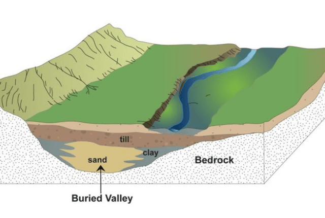
Beneath the surface of Great Britain are hundreds of ancient buried valleys, which have now been mapped for the first time by the BGS.
The buried valleys occur across Britain, from a 162 m-deep valley in Grangemouth, Scotland, to a 22 km-long valley under Melton Mowbray, Leicestershire and a 50 m-deep valley under Swansea.
The valleys mostly date from the last ice age, which ended around 11 500 years ago, and are ancient drainage networks from rivers and glaciers that over the years have become partly or completely buried by more recent sediments.
Sometimes a part of the valley peeks above the surface, but more often than not they are completely hidden underground, with no way for hydrologists, civil engineers, planners or construction companies to tell what lies beneath.
BGS first identified a hidden valley in the 1870s, under the River Mersey and has been collecting data from thousands of boreholes across Britain since then.
The digital age brought a new opportunity: to collect and collate all the buried valley data in one place and make it publicly available online.

Britain’s buried valleys might be underground, but they could and have had a huge impact on what happens above the surface.
We need to know where these buried valleys are for a number of reasons. They could be a target area for shallow geothermal energy, like in Cardiff. They could be unsuitable places for skyscrapers or bridges to be constructed. They cause problems for groundwater supplies, as they already do in South East England.
We combined historical BGS survey activities with over 200,000 borehole records from our national borehole database to identify these previously hidden features across the UK.
The buried valleys are all across Britain. The whole of the Cheshire basin looks flat as a pancake, but it has lots of features underneath it. These probably formed under an ice sheet that covered the area some 23 000 years ago.
The deepest system is in the middle of Scotland, under Grangemouth. It’s over 162 m deep and absolutely full of clay.
Now that we know where they are, the next stage of the work is to find out what’s in all of them, and whether they could be useful for providing geothermal energy or as a groundwater source for the whisky or manufacturing sectors.
Dr Tim Kearsey, BGS Geologist and project lead.
The Buried Valleys dataset is online now.
Relative topics
Media contact: Sarah McDaid ( sarah@mcdaidpr.co.uk / 07866789688)
Borehole data collected by BGS identifies buried valleys by telling us how much unconsolidated sediment sits above the top bedrock. On average this 8m thick, but over buried valleys it is 20-162m
– No buried valleys have been found in South West England or London
– They have been found in Scotland (Grangemouth, Glasgow and Aberdeen), Wales (Swansea, Cardiff and Newport), Northern England (Newcastle Upon Tyne, Liverpool and Manchester ), the Midlands (Doncaster, Coventry, Melton Mowbray) and East Anglia (Bury St Edmunds, Sudbury, Cambridge)
The British Geological Survey
The British Geological Survey (BGS), a component body of the Natural Environment Research Council (NERC), is the nation’s principal supplier of objective, impartial and up-to-date geological expertise and information for decision making for governmental, commercial and individual users. The BGS maintains and develops the nation’s understanding of its geology to improve policy making, enhance national wealth and reduce risk. It also collaborates with the national and international scientific community in carrying out research in strategic areas, including energy and natural resources, our vulnerability to environmental change and hazards, and our general knowledge of the Earth system.
More about the BGS can be found at www.bgs.ac.uk.
Twitter: @BritGeoSurvey