BGS launches new Geology Viewer
A new app providing easy access to the subsurface of Britain has been released by BGS.
30/06/2022 By BGS Press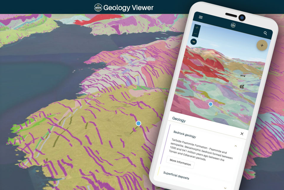

The BGS Geology Viewer has been designed to provide geology enthusiasts and the general public with bedrock and superficial geology maps of Great Britain. Anyone with a browser-enabled device — including mobiles, tablets and laptops — can use the free application.
The GPS-enabled viewer allows users to zoom to their location and tap the 3D map for information on each geology layer and how it was formed. The dynamic map legend updates to display only the visible rock formations and users can access further information with links to additional records in the BGS Lexicon. The viewer is also customisable, with a range of different base maps to choose from.
The application has been designed as a streamlined successor to some of BGS’s existing viewers. The mobile-first design is intended to make the new viewer available to a much wider range of users across different devices.
It will not be found in the Apple or Google App stores; instead, users can access the viewer through the BGS website.
Mobile users can also choose to add the app to their home screen and launch it like a native app. Initially launched in beta, further development is planned over the coming years to provide exciting new functionality to meet the evolving needs of our data users.
Following the launch, two older BGS applications, iGeology and the Geology of Britain Viewer, will be retired on 1 August.
For professional users who need to access BGS data as part of their business requirements, BGS GeoIndex is also available, containing borehole records and a comprehensive BGS data catalogue.
For further information, including frequently asked questions, troubleshooting and where to send feedback, please visit the BGS Geology Viewer application page.
Relative topics
Related news

Updated geological assessment of the Southern North Sea set to underpin future offshore infrastructure development
25/03/2026
The first regional assessment for 30 years will support offshore marine and subsurface planning for the UK’s low-carbon energy infrastructure, including the 2030 target of 45 to 50 GW generated through offshore wind.

New research could help provide a more reliable water supply for millions in rural Africa
24/03/2026
A new BGS-led study has revealed crucial insights into the longstanding challenges affecting the reliability and performance of rural water supply infrastructure in sub-Saharan Africa.

Call for new members and Chair to join the NERC facilities steering committees
25/02/2026
New members are needed to join the committees over the next four years.

Your views wanted: developing a geothermal energy subsurface data portfolio
24/02/2026
BGS is aiming to support the growth of the sector by providing the best-available, location-specific geothermal and ground source heat information as an accessible product or service.

Map of BGS BritPits showing the distribution of worked mineral commodities across the country
18/02/2026
BGS’s data scientists have generated a summary map of the most commonly extracted mineral commodities by local authority area, demonstrating the diverse nature of British mineral resources.

Funding awarded to map the stocks and flows of technology metals in everyday electronic devices
12/02/2026
A new BGS project has been awarded Circular Electricals funding from Material Focus to investigate the use of technology metals in everyday electrical items.

New UK/Chile partnership prioritises sustainable practices around critical raw materials
09/02/2026
BGS and Chile’s Servicio Nacional de Geología y Minería have signed a bilateral scientific partnership to support research into critical raw materials and sustainable practices.

Extensive freshened water confirmed beneath the ocean floor off the coast of New England for the first time
09/02/2026
BGS is part of the international team that has discovered the first detailed evidence of long-suspected, hidden, freshwater aquifers.

Funding secured to help mitigate ground risk in UK construction sector
05/02/2026
The BGS Common Ground project has been awarded new funding to help unlock the value of ground investigation data.

Can sandstones under the North Sea unlock the UK’s carbon storage potential?
02/02/2026
For the UK to reach its ambitious target of storing 170 million tonnes of carbon dioxide per year by 2050, it will need to look beyond the current well-studied geographical areas.

Quaternary UK offshore data digitised for the first time
21/01/2026
The offshore wind industry will be boosted by the digitisation of a dataset showing the Quaternary geology at the seabed and the UK’s shallow subsurface.

Suite of ten new soil reference materials released
02/01/2026
BGS has a longstanding track record of producing high-quality reference materials and has released ten new soil reference materials.