BGS data supports new tool to track geological changes in abandoned coal mines
BGS data supports new tool to track geological changes in abandoned coal mines.
20/11/2020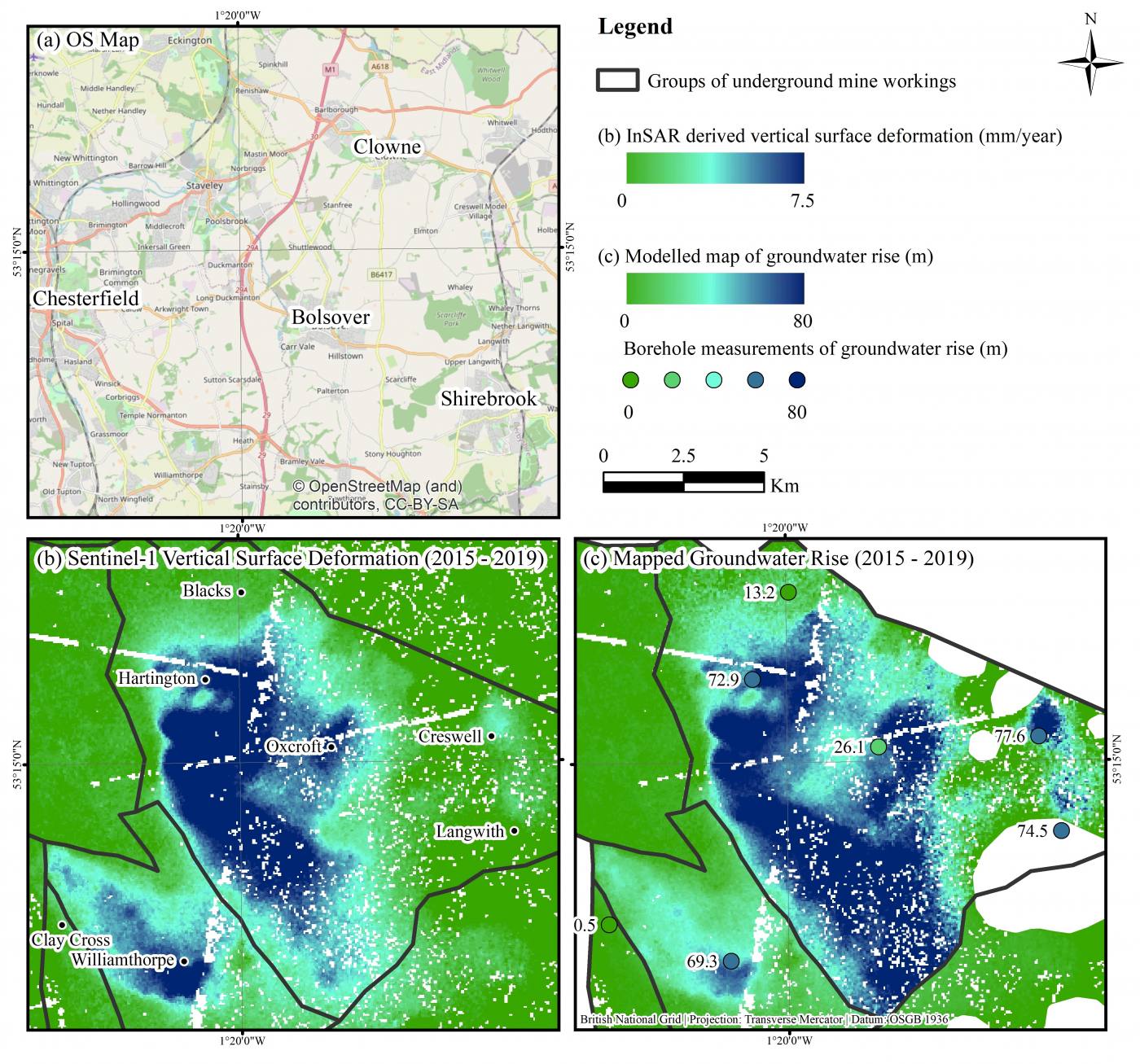

BGS is part of a multi-disciplinary team led by the University of Nottingham to develop a remote monitoring tool designed to help authorities manage public safety and environmental issues in recently abandoned coal mines.
The tool uses satellite radar imagery to capture millimeter-scale measurements of changes in terrain height. These measurements, when integrated with geological process models, can be used to monitor and forecast groundwater levels and changes in geological conditions deep below the earth’s surface in former mining areas. Ultimately this can help forecast where surface discharge of mine water may occur.
The study uses an advanced InSAR technique, called Intermittent Small Baseline Subset (ISBAS), developed by the University of Nottingham and Terra Motion Ltd and uses geological data provided by the BGS.
The method has been implemented over Nottinghamshire coalfields and the findings published in a paper ‘Modelling groundwater rebound in recently abandoned coalfields using DInSAR’ in the journal Remote Sensing of the Environment.
The team hopes to integrate results into an existing screening tool developed by the Environment Agency and Coal Authority to help local planning authorities, developers and consultants design sustainable drainage systems in coalfield areas, with potential to be scaled to coalfields across the UK.
The research was led by University of Nottingham PhD, David Gee and funded by the GeoEnergy Research Centre and Terra Motion Limited. ENVISAT and Sentinel-1 SAR data were provided by the European Space Agency with geological data by BGS and hydrogeological data by the Coal Authority.
Luke Bateson and Alessandro Novellino from the BGS Earth Observation and Geodesy capability have supported the geological interpretation and modelling of the InSAR results.
Read the full story on the University of Nottingham website
You can read more about the Interferometric Synthetic Aperture Radar (InSAR) technique from BGS Remote Sensing Geologist, Alessandro Novellino in ‘Mapping Ground Deformation from Space’, on the British Geological Survey blog.
Luke Bateson
Acting head of shallow geohazards and Earth observation; head of geodesy and remote sensing (Keyworth)
Dr Alessandro Novellino
Remote sensing geoscientist
Relative topics
Related news

Isotopes and science: my student placement at BGS
08/04/2026
Industrial placements at BGS for undergraduate students give real-life experience of working in laboratories and learning different analytical techniques.

Updated geological assessment of the Southern North Sea set to underpin future offshore infrastructure development
25/03/2026
The first regional assessment for 30 years will support offshore marine and subsurface planning for the UK’s low-carbon energy infrastructure, including the 2030 target of 45 to 50 GW generated through offshore wind.

New research could help provide a more reliable water supply for millions in rural Africa
24/03/2026
A new BGS-led study has revealed crucial insights into the longstanding challenges affecting the reliability and performance of rural water supply infrastructure in sub-Saharan Africa.

Call for new members and Chair to join the NERC facilities steering committees
25/02/2026
New members are needed to join the committees over the next four years.

Your views wanted: developing a geothermal energy subsurface data portfolio
24/02/2026
BGS is aiming to support the growth of the sector by providing the best-available, location-specific geothermal and ground source heat information as an accessible product or service.

Map of BGS BritPits showing the distribution of worked mineral commodities across the country
18/02/2026
BGS’s data scientists have generated a summary map of the most commonly extracted mineral commodities by local authority area, demonstrating the diverse nature of British mineral resources.

Funding awarded to map the stocks and flows of technology metals in everyday electronic devices
12/02/2026
A new BGS project has been awarded Circular Electricals funding from Material Focus to investigate the use of technology metals in everyday electrical items.

New UK/Chile partnership prioritises sustainable practices around critical raw materials
09/02/2026
BGS and Chile’s Servicio Nacional de Geología y Minería have signed a bilateral scientific partnership to support research into critical raw materials and sustainable practices.

Extensive freshened water confirmed beneath the ocean floor off the coast of New England for the first time
09/02/2026
BGS is part of the international team that has discovered the first detailed evidence of long-suspected, hidden, freshwater aquifers.

Funding secured to help mitigate ground risk in UK construction sector
05/02/2026
The BGS Common Ground project has been awarded new funding to help unlock the value of ground investigation data.

Can sandstones under the North Sea unlock the UK’s carbon storage potential?
02/02/2026
For the UK to reach its ambitious target of storing 170 million tonnes of carbon dioxide per year by 2050, it will need to look beyond the current well-studied geographical areas.

Quaternary UK offshore data digitised for the first time
21/01/2026
The offshore wind industry will be boosted by the digitisation of a dataset showing the Quaternary geology at the seabed and the UK’s shallow subsurface.