Artificial intelligence helps scientists identify 3000 moving slopes potentially at risk of landslide
A new approach that combines AI and satellite data has been used by scientists to detect actively moving landslides at a national scale.
25/09/2025 By BGS Press

Landslides cause significant disruption to the road and rail network across Great Britain and can lead to fatalities. Identifying active slope failure is a difficult task, as monitoring is costly and time consuming, especially at a national scale.
In collaboration with the University of Florence in Italy, BGS has used a new, semi-automated method that uses artificial intelligence (AI) to identify the slopes that are actively moving, highlighting areas potentially at risk.
Previously, BGS has used interferometric synthetic aperture radar, or InSAR, for monitoring landslides. One of the benefits of InSAR is the large amount of information available, especially at a national scale; but analysing all these data present a challenge for scientists. To help tackle this problem, we have developed a semi-automated method that combines a type of AI called machine learning with clustering tools. The benefit of this approach is that we can analyse data for the whole of Great Britain, which wouldn’t have been possible before.
Results from this recent analysis highlighted around 3000 slopes that showed consistent movement of over 2.5 mm per year between 2018 and 2022. These actively moving slopes affect approximately 14 000 km of road and 360 km of railway — 2.4 per cent and 1 per cent of the entire national network, respectively.
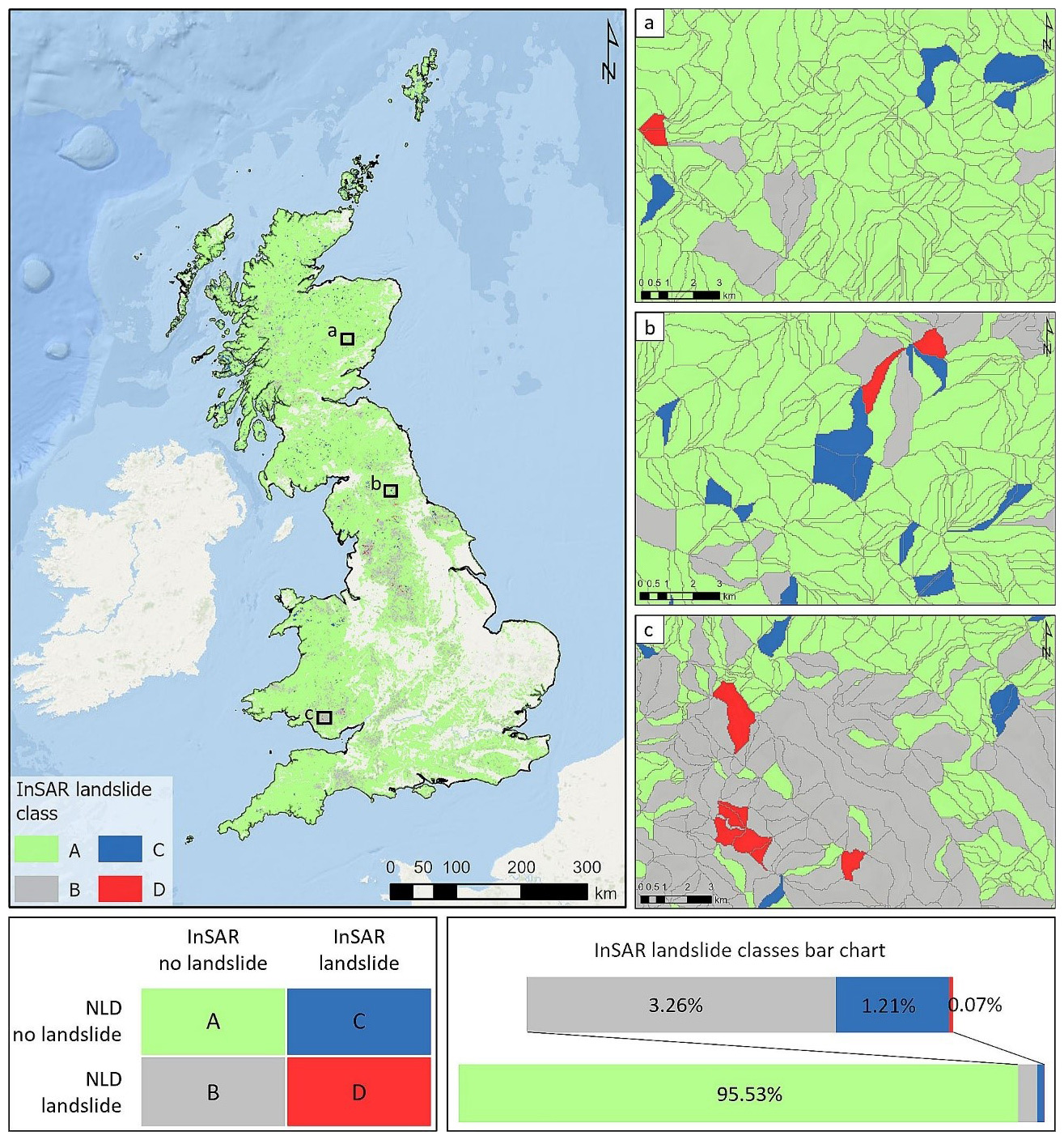
InSAR landslide inventory map with associated matrix and the InSAR landslide classes bar chart. Additionally, three zooms of the map from (a) Scotland; (b) England; (c) Wales. NLD: BGS National Landslide Database. © Medici et al. (2025).
The slopes deemed unstable are not all linked to landslides. Rather, they show the areas that should be focused on not only for future landslide research and mapping but also for the effect on local infrastructure, such as buildings and roads.

Our new, semi-automated approach supports the work of landslide specialists and provides a practical solution for large-scale geohazard management. The tool has helped to classify more than 300 000 slopes around the UK and has highlighted 3000 slopes that have moved in a four-year period.
Satellite InSAR data has enormous potential for understanding ground deformation, but its complexity and the volume of data require advanced automated tools to extract meaningful information. Our semi-automated method helps bridge this gap by identifying the most critical areas to focus on, enabling efficient monitoring and helping to prevent serious damage.
Dr Alessandro Novellino, BGS remote sensing geologist
This approach already provides a powerful disaster-management tool, allowing decision makers to quickly identify areas that are currently at risk from ground motion. By highlighting these vulnerable areas, it supports smarter prioritisation of detailed field surveys, maintenance, and mitigation strategies, reducing costs and improving safety.
Next steps will focus on refining this national-scale analysis by integrating more detailed topographical data, to move from identifying unstable slopes to automatically mapping individual landslides within those slopes. This will enable more precise classification of landslide types and extents and the likely triggering mechanisms. The results will be shared with key stakeholders, including local authorities, infrastructure owners and the Natural Hazards Partnership.
Camilla Medici, postdoctoral researcher at the University of Florence
The research paper, Machine learning and clustering for supporting the identification of active landslides at national scale, is now available to read.
Related news

Updated geological assessment of the Southern North Sea set to underpin future offshore infrastructure development
25/03/2026
The first regional assessment for 30 years will support offshore marine and subsurface planning for the UK’s low-carbon energy infrastructure, including the 2030 target of 45 to 50 GW generated through offshore wind.

New research could help provide a more reliable water supply for millions in rural Africa
24/03/2026
A new BGS-led study has revealed crucial insights into the longstanding challenges affecting the reliability and performance of rural water supply infrastructure in sub-Saharan Africa.

Call for new members and Chair to join the NERC facilities steering committees
25/02/2026
New members are needed to join the committees over the next four years.

Your views wanted: developing a geothermal energy subsurface data portfolio
24/02/2026
BGS is aiming to support the growth of the sector by providing the best-available, location-specific geothermal and ground source heat information as an accessible product or service.

Map of BGS BritPits showing the distribution of worked mineral commodities across the country
18/02/2026
BGS’s data scientists have generated a summary map of the most commonly extracted mineral commodities by local authority area, demonstrating the diverse nature of British mineral resources.

Funding awarded to map the stocks and flows of technology metals in everyday electronic devices
12/02/2026
A new BGS project has been awarded Circular Electricals funding from Material Focus to investigate the use of technology metals in everyday electrical items.

New UK/Chile partnership prioritises sustainable practices around critical raw materials
09/02/2026
BGS and Chile’s Servicio Nacional de Geología y Minería have signed a bilateral scientific partnership to support research into critical raw materials and sustainable practices.

Extensive freshened water confirmed beneath the ocean floor off the coast of New England for the first time
09/02/2026
BGS is part of the international team that has discovered the first detailed evidence of long-suspected, hidden, freshwater aquifers.

Funding secured to help mitigate ground risk in UK construction sector
05/02/2026
The BGS Common Ground project has been awarded new funding to help unlock the value of ground investigation data.

Can sandstones under the North Sea unlock the UK’s carbon storage potential?
02/02/2026
For the UK to reach its ambitious target of storing 170 million tonnes of carbon dioxide per year by 2050, it will need to look beyond the current well-studied geographical areas.

Quaternary UK offshore data digitised for the first time
21/01/2026
The offshore wind industry will be boosted by the digitisation of a dataset showing the Quaternary geology at the seabed and the UK’s shallow subsurface.

Suite of ten new soil reference materials released
02/01/2026
BGS has a longstanding track record of producing high-quality reference materials and has released ten new soil reference materials.