In 1832, Henry de la Beche was appointed by the Board of Ordnance ‘to affix geological colours to maps of Devonshire, with portions of Somerset, Dorset and Cornwall’. By the end of 1834, seven sheets were completed and, after consultation, the Treasury funded the Ordnance Geological Survey, then part of the Ordnance Survey.
Origins
The mapping proceeded and, by 1839, fourteen sheets and de la Beche’s first ‘Memoir’, the ‘Report on the Geology of Cornwall, Devon, and West Somerset’, were published.
In 1844, William Edmond Logan created and published the horizontal and vertical sections. The horizontal sections were meticulously surveyed on a scale of six inches to a mile while the vertical ones were usually at a scale of one inch to forty feet.
By 1845, nearly the whole of Somerset, the western half of Gloucestershire, the counties of Monmouth, Glamorgan, Carmarthen and Pembroke, and nearly the whole of Brecknock and Herefordshire together with part of Worcestershire had been mapped and published and by 1854 the whole of Wales had been completed.
Six-inch to the mile scale and superficial deposits
Mapping was still undertaken on the scale of one inch to one mile but, following the example in Ireland, the new mapping of the northern counties was done on six-inch to the mile scale field sheets.
The importance of the superficial deposits (in most cases, the sands, gravels and boulder clays deposited during the glacial period) was also recognised. Mapping of these began at about the same time.
Expansion and a recruitment drive for geologists
After a Royal Commission on Coal in 1866, the Geological Survey greatly expanded under Roderick Impey Murchison. Twenty-one field geologists were recruited during 1868–69. By this time, the survey had progressed northwards and eastwards to a line from Liverpool to Selby and as far east as Retford, Melton Mowbray, Market Harborough, Huntingdon, London, Chatham and Folkestone and parts further north of Lancashire, Westmoreland and some of the Northumberland coalfield.
Mapping stops in the 1880s!
During the 1880s there was a (short-lived) cessation of mapping at six-inches to the mile, with the aim of pushing the completion of the primary mapping of England and Wales, the latter being completed in 1883. Staff were then transferred either to Scotland or to map the ‘drift’ (superficial deposits) of the southern counties that was missed during the early surveys. Sheets continued to be produced in hand-coloured form up to 1903.
Eventually, the typically colour-printed ‘New Series’ one-inch geological maps superseded the older, hand-coloured maps. For much of central and southern England and Wales ,the New Series was on new sheet lines with different sheet numbering. In northern England, the older hand-coloured maps and New Series sheet lines coincided, although the sheet numbering was different.
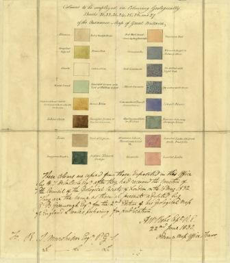

Standard map colours from 1932. BGS © UKRI.
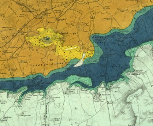
Extract of an early one-inch, hand-coloured map covering Swindon. BGS © UKRI.
Timeline
| 1832 | Sir Henry de la Beche offers to geologically map Cornwall and Devon. The offer is accepted by the Ordnance Survey and surveying begins using one-inch to the mile field slips. |
| 1835 | The Board of Ordnance agree to a geological survey of the English counties. |
| 1835 | Sir Henry De la Beche becomes a full-time employee of the Ordnance Survey and the Ordnance Geological Survey is created. |
| 1835 | The survey is located in Craig’s Court, Whitehall. |
| 1838 | Sir Henry de la Beche is appointed to a commission to recommend the most suitable stone for building the new Houses of Parliament to replace those destroyed in a fire. |
| 1839 | Fourteen sheets have been completed to this date covering Cornwall, Devon and West Somerset. The maps are issued hand-coloured in watercolours. |
| 1839 | Mapping transfers to South Wales and adjoining areas and William Edmond Logan participates. |
| 1839 | The first memoir is published, ‘Report on the Geology of Cornwall, Devon, and West Somerset’, by Henry T de la Beche, FRS, &c., Director of the Ordnance Geological Survey. It serves as a model for subsequent survey publications. |
| 1841 | The Museum of Economic Geology opens in the survey premises at Craig’s Court in Whitehall. |
| 1841 | ‘Figures and descriptions of the Palaeozoic Fossils of Cornwall, Devon and West Somerset’, the second survey Memoir, is published. |
| 1844 | Published horizontal and vertical sections are introduced. |
| 1845 | The Geological Survey of Great Britain and Ireland is set up by an Act of Parliament. Victoria Regina LXIII 31st July 1845. The act is to ‘facilitate the completion’ of the survey. The survey is transferred from the Board of Ordnance to the Office of Woods and Works. |
| 1845 | A C Ramsay is made Local Director for England and Wales. The English field staff is six:
The survey also employs Edward Forbes as palaeontologist, Lyon Playfair as chemist and Robert Hunt as keeper of the mining records. |
| 1845 | By this date, the maps of nearly the whole of Somerset, the western half of Gloucestershire, the counties of Monmouth, Glamorgan, Carmarthen, and Pembroke, and nearly the whole of Brecknock and Herefordshire together with part of Worcestershire have been completed and published. |
| 1851 | The Museum of Practical Geology (formerly the Museum of Economic Geology, formed in 1841) opens. The Geological Survey moves to 28 Jermyn Street. |
| 1852 | The last one-inch map of the primary survey of Wales is published. |
| 1853 | The survey is transferred to the Department of Science and Arts, under the Board of Trade. |
| 1854 | By this date the survey of the whole of Wales has been completed and published and field work is advancing eastwards into the central counties of England. |
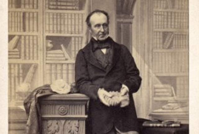
| 1855 | Sir Henry de la Beche dies and is succeeded by Sir Roderick Impey Murchison as director. |
| 1856 | The Department of Science and Arts moves and is now under the Education Department of the Privy Council. |
| 1858 | The first quarter-inch to the mile geological sheets are published. |
| 1858 | The one-inch maps spread eastwards to complete the Midlands coalfields and approaches to London. |
| 1860 | Edward Hull starts mapping in the Lancashire coalfield, on the scale of six-inches to the mile. Mapping at this scale is adopted for the whole of Northern England. |
| 1860 | The first six-inch maps are published:
|
| 1862 | Maps published to date:
|
| 1866 | Royal Commission on coal. There is growing interest in coalfield areas and in drift mapping, the latter for use by agriculturalists, civil engineers, medical authorities and town planners. |
| 1867–1868 | Expansion of the survey. Twenty-one field geologists are recruited. Total staff in England and Wales is 36 and Ramsay is the senior director for England and Wales. |
| 1871 | The area covered by published maps covers most of the country south-west of a line drawn from Kendal to Southend on the Thames. |
| 1872 | Andrew Crombie Ramsay succeeds Murchison as director general. Bristow becomes the director for England and Wales. |
| 1872 | The School of Mines leaves the survey and is passed to Imperial College to become the Royal School of Mines. |
| 1871 | Maps published to date:
|
| 1881 | Maps published to date:
|
| 1882 | Archibald Geikie succeeds Ramsay as director general. |
| 1881 | There is a cessation of publishing six-inch maps so that staff can focus on the completion of one-inch scale maps. |
| 1883 | The Mining Records Office leaves the survey and comes under the Department of Inspectors of Mines at the Home Office. |
| 1885 | The number of staff employed in England reduces to 12 from 23 with transfers to Scotland and Ireland. The survey’s focus is on drift mapping. |
| 1886–1893 | Geikie brings microscopic petrology to the fore in the survey with the appointment of five petrologists:
|
| 1889 | Whitaker’s Geology of London is published. |
| 1883 | The last one-inch map of the primary survey of England is published. |
| 1890–1904 | Geikie develops a series of great stratigraphical memoirs on the Pliocene, Jurassic, Cretaceous and Silurian rocks of Britain. |
| 1889–1896 | Colour-printed quarter-inch to the mile maps are published. |
| 1893 | New Series one-inch geological maps (solid and drift) based on the revision of the Old Series sheets begin to appear and are colour printed. |
| 1893–1900 | Serious dissatisfaction is felt by the staff of the survey. An official enquiry is set up in 1900. |
| 1898 | The last hand-coloured sheet is produced: Sheet 100, Isle of Man. |
| 1900 | A committee is set up to ‘Enquire into the organisation and staff of the Geological Survey and Museum of Practical Geology’ (the Wharton Committee). |
| 1900 | Total survey staff falls to 41. |
| 1901 | Jethro Justinian Harris Teall takes over from Archibald Geikie with the diminished title of director. |
Bibliography
- Bailey, E B. 1952. Geological Survey of Great Britain. (London: Murby.)
- Flett, J S. 1937. The first hundred years of the Geological Survey of Great Britain. (London: HMSO.)
- McIntosh, R P. 2012. Geological Survey of Great Britain and Ireland — a contemporary account of the survey, 1897 (3.17 MB pdf). Extracted and illustrated from 1897 Geological Survey of Great Britain Summary of Progress (unpublished).
- McKenna, G (editor). [Unpublished manuscript]. Instructions for the Local Directors of the Geological Survey of Great Britain and Ireland (330 KB pdf) by Henry de la Beche, 22 May 1845. Selected documents from the BGS Archives No. 1
- Wilson, H. 1985. Down to Earth: one hundred and fifty years of the British Geological Survey. (Edinburgh: Scottish Academic Press.)
You may also be interested in

BGS maps portal
High-resolution viewing of images of almost all the small- and medium-scale geological maps produced by the BGS since mapping started in 1832.
Geological Survey history — Scotland
A history of geological mapping in Scotland, including timeline and early beginnings.
Geological Survey history — Ireland
A history of geological mapping in Ireland
Geological survey historical notes
Brief historical notes and links to key documents on the early 1:63 360 map series for England and Wales, Scotland and Ireland.