Data modelling is an important part of the wider research around the environment and human health. Statistical modelling techniques of soil property data are used to:
- look at differences in the concentration of potentially harmful substances (PHS) in different cities
- develop normal background concentrations (NBCs) of soil contaminants for use in human health risk assessment
- predict the mobility at different spatial scales (urban and rural scales; flood catchment)
- identify anthropogenic and geogenic signatures to assess the past impact of anthropogenic activity and urban land use
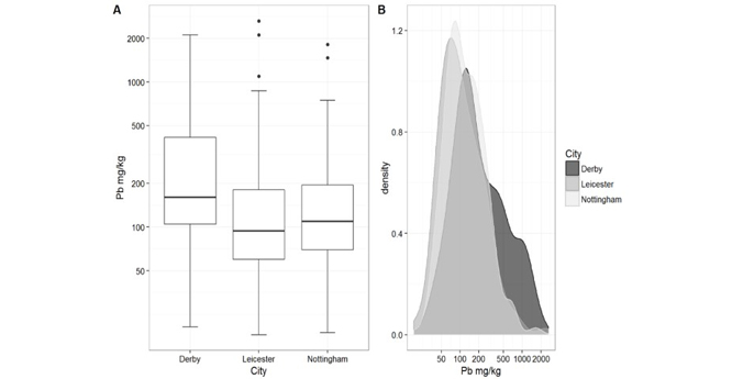

Comparison of lead (Pb) concentration in Derby, Leicester and Nottingham. A: boxplot; B: probability density plot (from Cave et al., 2018).
The team use samples and data from the extensive BGS G-BASE project as well as those from individual, site-specific studies. We apply a variety of statistical modelling approaches to laboratory and field-based measurements to identify different physical and chemical properties of soil e.g. near infra-red; total element analysis; soil pH, etc. The range of statistical modelling approaches includes least squares linear regression, multiple linear regression, stepwise linear regression, principal component analysis and machine learning (random forest modelling) to explore the relationships between geology and geochemistry, providing robust predictions of spatial contamination and its health impacts.
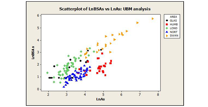
Total vs bioaccessible arsenic for topsoils collected from Glasgow, Humberside, London, Northampton and Swansea (from Appleton et al., 2012).
Spatial modelling techniques can be carried out on a relatively small number of samples to predict element mobility on wider urban or regional scales. Application of our modelling techniques on spatial datasets allows us to create urban and regional maps of bioaccessibility and understand the relationship between soil geochemistry and measurements of health deprivation.
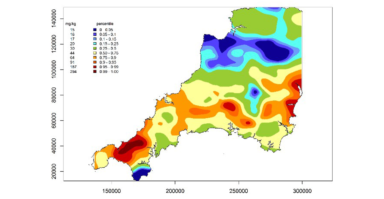
Interpolated map of predicted bioaccessible arsenic in south-west England (from Wragg et al., 2018).
Relative topics
Ander, E L, Johnson, C C, Cave, M R, Palumbo-Roe, B, Nathanail, C P, and Lark, R M. 2013. Methodology for the determination of normal background concentrations of contaminants in English soil. Science of the Total Environment, Vols. 454–455, 604–618.
Appleton, J D, Cave, M R, and Wragg, J. 2012. Modelling lead bioaccessibility in urban topsoils based on data from Glasgow, London, Northampton and Swansea, UK. Environmental Pollution, Vol. 171, 265–272.
Cave, M R, Wragg, J, and Lister, R. 2018. The effect of lead in soil on crime deprivation in Derby, Leicester and Nottingham. Applied Geochemistry, Vol. 88 Part B, 198–212.
Cave, M R, Vane, C H, Kim, A, Moss-Hayes, V L, Wragg, J, Richardson, C L, Harrison, H, Nathanail, C P, Thomas, R, and Willis, G. 2015. Measurement and modelling of the ingestion bioaccessibility of polyaromatic hydrocarbons in soils. Environmental Technology & Innovation, Vol. 3, 35–45.
Cave, M R, Wragg, J, and Harrison, H. 2013. Measurement modelling and mapping of arsenic bioaccessibility in Northampton, United Kingdom. Journal of Environmental Science and Health, Part A Toxic/Hazardous Substances and Environmental Engineering, Vol. 48(6), 629–640.
Kirkwood, C, Cave, M, Beamish, D, Grebby, S, and Ferreira, A. 2016. A machine learning approach to geochemical mapping. Journal of Geochemical Exploration, Vol. 167, 49–61.
McIlwaine, R, Doherty, R, Cox, S F, and Cave, M R. 2017. The relationship between historical development and potentially toxic element concentrations in urban soils. Environmental Pollution, Vol. 220 Part B, 1036–1049.
Wragg, J, Cave, M, Hamilton, E, and Lister, T E. 2018. The link between soil geochemistry in south-west England and human exposure to soil arsenic. Minerals, Vol. 8(12), 570.
You may also be interested in

Measuring geochemical hazards
Understanding and assessing geochemical hazards in the environment has been a part of the BGS portfolio of research for over 50 years.