In October 2011, the soils and geophysical tomography teams at the BGS installed a network of soil moisture sensors into a hillside in North Yorkshire, UK. These sensor networks represent a major advance in ways to study soil moisture because they transmit information constantly from the field site back to scientists’ computers.
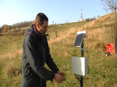


Barry Rawlins explains how SENSOR NET operates a network of semi-wireless sensors to study soil moisture on a hillslope.
The sensors have been installed according to a nested sampling scheme so that we can examine how variation in soil moisture is affected by factors that operate at different spatial scales. Eight clusters of sensors (such as the one shown in Figure 1) are spread across the site. Differences in soil moisture readings between these sensors will be due mainly to:
- the tendency of soils at the bottom of the slope to accumulate water after rainfall
- high densities of coarse particles in the soils at the bottom of the slope, contrasting with fine (clay) particles at the top of the slope
Figure 1 shows how sensors within a cluster can be arranged so that comparisons can be made over distances from 9 m to 30 cm. This will allow us to investigate the importance of finer-scale factors in determining soil moisture content, such as the shape of the land surface and the size of the particles in the soil.
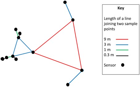
Figure 1: a nested structure showing the positions of the sensors (black discs) and the distances between them (coloured lines).
We have installed 96 sensors across the field site in this nested scheme so that we can quantify the effects at different scales of soil type, slope position and other factors on soil moisture following rainfall events.
Why is this research important?
It is important that we know how soil moisture varies over different spatial scales and over time. For example, the information from this project would enable us to design the most efficient sample network for specific tasks such as monitoring soil water content at field scale, perhaps as input to catchment-scale hydrological models, or for monitoring variations over a few metres on unstable ground, where variations in water content may be risk factors for landslides.
This understanding of scale dependence will also help us to integrate information from sensors like the ones we are deploying at Hollin Hill with other sources of information. For example, satellites can now estimate soil moisture content over large regions (kilometre scale) of the Earth’s surface.
This information will be most useful if it can be combined with direct measurements from an efficiently designed sensor network and so contribute to a better understanding of feedbacks between the land surface and atmosphere, limitations on crop yield by drought, and how storage of water in soil affects hydrological processes and so the risk of flooding.
Contact
If you would like to discover more then please contact Philip Meldrum.
You may also be interested in
Technologies
Creating innovative technologies with in the field of geophysical and geotechnical monitoring.
BGS PRIME: an early warning system for slope failure
Dam and slope failures can lead to the wide-scale destruction of property and, in some cases, catastrophic loss of life.

Hollin Hill Landslide Observatory
Accurately monitoring and eventually predicting landslide movement through scientific research.