Kimmeridge Bay can be reached either directly by car via a toll road or alternatively by foot along the South West Coast Path, which passes through Kimmeridge from Worth Matravers and on to Worbarrow Bay. The bay forms part of the Jurassic Coast World Heritage Site.
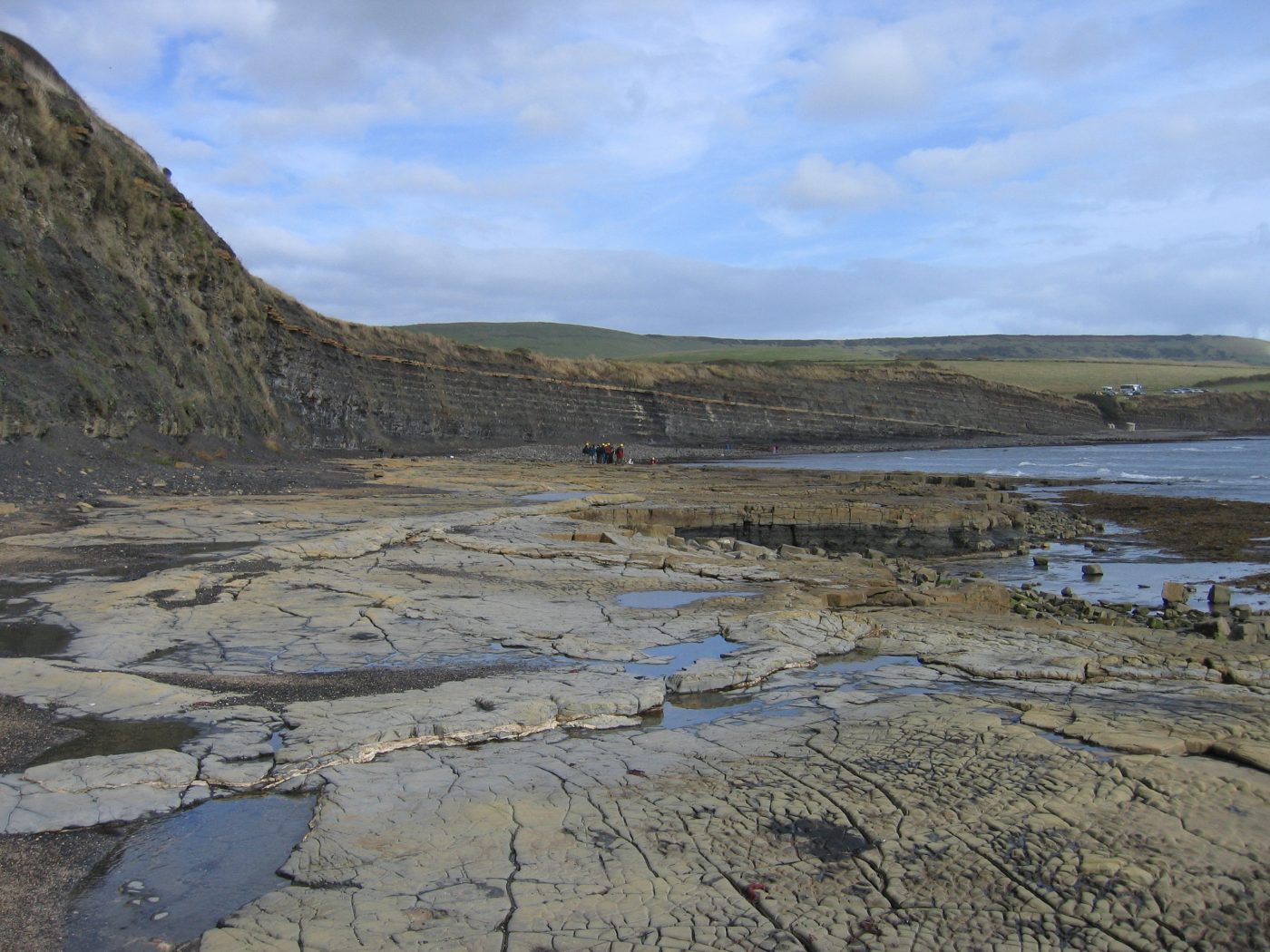

Kimmeridge Bay, showing the dark, organic-rich nature of the Kimmeridge Clay Formation and the wave-cut rock platform. BGS © UKRI.
Geology
The rocks at Kimmeridge Bay are composed of highly organic, black mudstones with a slate-like bedding structure, allowing it to be broken easily along these lamination planes. The rock, known as the Kimmeridge Clay Formation, is of Kimmeridgian age (157.3 and 152.1 million years old) from the Jurassic Period. The names of the rock and time period are not a coincidence; the Kimmeridge Clay Formation is one of the most geologically significant formations in the UK. The rock acts as the source rock for much of the UK’s oil reserves under the North Sea. You can see, or perhaps more easily smell, the oil content in the Kimmeridge Clay Formation on fresh exposures of the rock.
Structure
The rocks across the Isle of Purbeck, to the east of Kimmeridge, are significantly folded and form part of the Purbeck Monocline. This enormous, east–west-trending structure runs under the English Channel but is exposed here where the near-vertical limb of the fold is exposed. It produces the unique structure of the Isle of Purbeck, with two hard rock ridges (the Purbeck Ridge and the coastal cliffs) separated by the soft Wealden clays and muds, which formed 145 and 126.3 million years ago during the Cretaceous Period. Today, these soft clays are responsible for the large number of small bays along the Purbeck coast.
Fossils
When the formation was deposited, Kimmeridge was part of a shallow sea environment where silts and muds settled down upon the sea floor alongside a host of expired organic life. The isolated, low-oxygen environment of this sea floor promoted the rapid preservation of fossils, which can now be found in great abundance at Kimmeridge today. If you would like to see a comprehensive collection of these fossils, the nearby Etches Collection Museum can be found in the village of Kimmeridge itself.
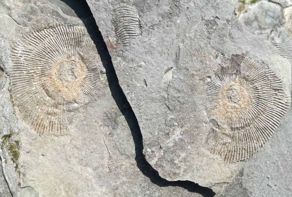
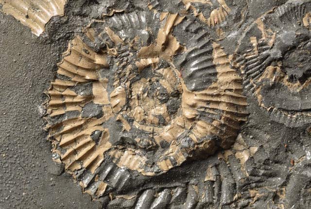
Kimmeridgian-aged ammonites preserved between laminations of the Kimmeridge Clay Formation. Because ammonites were abundant in Jurassic seas and preserve easily due to their hard shells, they make excellent index fossils. In biostratigraphy, an ‘index fossil’ is a fossil that characterises a particular geological time period. © Cameron Fletcher.
At Kimmeridge Bay, the rock is layered into thin horizons of strata called ‘laminations’. The fossils are preserved between them and the sequential layers of the shale rock allow for a detailed view of the geological time period when you study the fossils from different horizons. Do note that the site is a Site of Special Scientific Interest (SSSI), so hammering the rock wall in search of fossils is forbidden (and dangerous!)
There is great number of shelled creatures, such as ammonites and bivalves, at Kimmeridge because the preservation process preferentially preserves the hard, outer parts of the animals. The soft parts of the dead creatures often decay before being buried under the ocean sediments, which eventually form the encapsulating rock.
As groundwater filters through the rock during the fossilisation process, the corpse of the creature is steadily replaced with minerals present in the water, leaving a replaced stone cast of the original form. Kimmeridge Clay is special in that fossils are preserved in huge abundance, which also allows for larger, more intricate and rarer fossils to be observed: for example, the first instance of ammonite eggs was found at Kimmeridge Bay.
Modern flora and fauna
Kimmeridge contains several secluded rock pools and shallow rocky reefs that can be accessed with relative ease. Kimmeridge Bay is a particularly great place to investigate rockpools, as the bay is a wave-cut platform of rock as opposed to a singular sandy bar. Sea anemones, crabs and other shallow, benthonic life can be found in abundance here. More rarely, barrel jellyfish, seals and dolphins can also be seen in the bay, depending on the time of year and the presence of people. Fantastic underwater flora such as peacocks tail and coralline seaweed can also be found at Kimmeridge, as the area is a Marine Conservation Zone, which prevents trawling and other extractive activities.
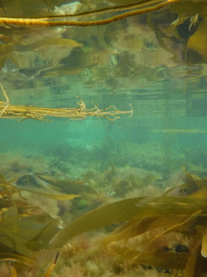
Kimmeridge Bay is shallow and sheltered, which makes it a great location for snorkelling. This image shows the extent of the shallow rocky reefs found there. © Cameron Fletcher.
Activities
Kimmeridge Bay has facilities for modest outdoor watersports including kayaking and paddleboarding, as a pontoon, nearby car park and toilets can be found at the south-eastern tip of the beach, alongside the Wild Seas Centre, which is a marine life conservation visitor outpost. The bay is a natural shield from the wind, which makes it relatively calm internally for watersports (weather depending!) compared to the open ocean. Adventurous kayakers may consider making the six-mile westward voyage to Worbarrow Beach and back, but do consider that the mobile phone signal is patchy, the area remote and the sea currents considerably stronger outside of the bay.
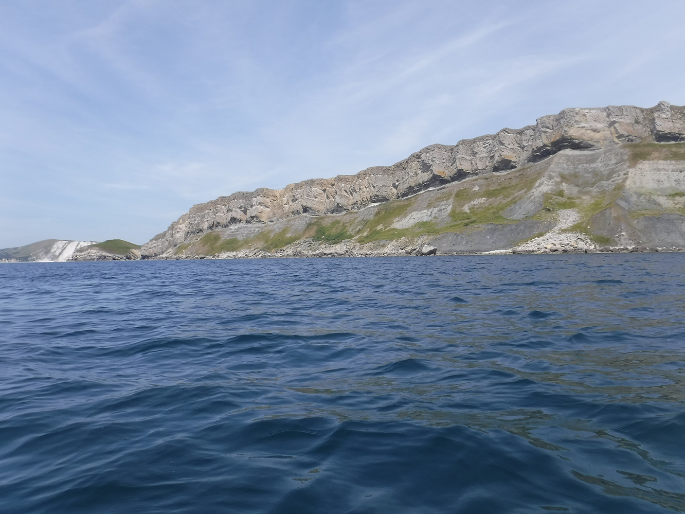
A photograph of the southern coast of the Brandy Bay cliffs, the section of coast between Wolbarrow Bay (visible left) and Kimmeridge Bay. These cliffs are comprised of the same Jurassic-aged Kimmeridge Clay Formation. © Cameron Fletcher.
Warnings
Coastal paths can be treacherous, particularly in wet and windy conditions, so sturdy boots are advisable. The Kimmeridge Clay and other associated rock formations in south Dorset are prone to building high, somewhat unstable cliffs, which pose a significant risk of landslides and rockfalls. Always maintain a safe distance from the cliffs in order to prevent personal injury whilst walking! Tides can also pose a significant risk to certain parts of the shore if you walk outside of the main Kimmeridge Bay. Walking along the South West Coast Path on the cliffs is safer for hikers looking to explore further along the coast.
The western access along the South West Coast Path from Kimmeridge to Tyneham may be blocked by the Ministry of Defence as it passes through military firing ranges: check online for accessibility details. When passing through military ranges, it is imperative you stay within the marked public walkways, avoid touching military debris and observe red flags and red lights, as these are indicative of live firing.
Further information
- Firing range information: https://www.dorsetcouncil.gov.uk/countryside-coast-parks/beaches-and-coast/the-lulworth-ranges-and-tyneham-village
- Etches Collection Museum: https://www.theetchescollection.org/
- Wild Seas Centre: https://www.dorsetwildlifetrust.org.uk/wild-seas-centre
- Ballard Down lies about 10 km east of Kimmeridge Bay, while Lulworth Cove is approximately 5 km to the west
Reference
Etches, S, Clarke, J, and Callomon J. 2009. Ammonite eggs and ammonitellae from the Kimmeridge Clay Formation (Upper Jurassic) of Dorset, England. Lethaia, Vol. 42, 204–217. DOI: https://doi.org/10.1111/j.1502-3931.2008.00133.x
About the author
Cameron Fletcher is a core scanning technician at BGS.
Relative topics
You may also be interested in
Discovering Geology
Discovering Geology introduces a range of geoscience topics to school-age students and learners of all ages.
Maps and resources
Download and print free educational resources.
Postcard geology
Find out more about sites of geological interest around the UK, as described by BGS staff.