On 6 May 2012, the BGS Landslide Response Team received media alerts of a landslide affecting the famous ruined village of Hallsands, South Devon. It was reported that a 200 tonne, 10 m-long section of coastal cliff had collapsed damaging a stone barn and threatening the stability of a popular cliff-top viewing platform.
Whilst this was a relatively small failure by national standards, the inhabitants of the two remaining houses in the village were evacuated amid fears that the access route to these houses would be undermined. As a result of the damage to property, the need for evacuation measures and a well-documented history of coastal erosion in the area, the BGS Landslide Response Team visited the site to assess the landslide.
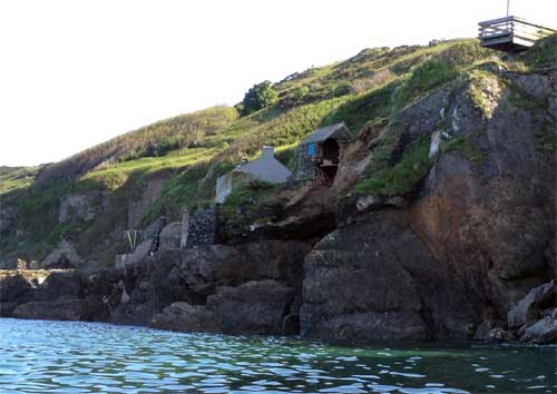

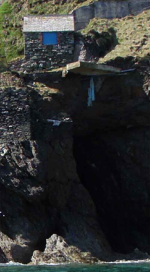
Landslide scar and proximity to the village access road and viewing platform. Note the cave extending under the barn. BGS © UKRI.
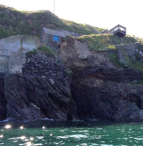
Damage to the stone barn adjacent to the two remaining houses. BGS © UKRI.
Geology and landforms
The remains of the village of Hallsands sit on a discontinuous platform of metamorphic rocks comprising Start Mica Schists at approximately 7 m above sea level. Deep ravines separate the promontories of this platform. The seaward edge of the platform forms a steep cliff. Landward of the platform is another steep cliff, formed in the same mica schists and capped by head deposits. Head and raised beach deposits of sand and gravel are locally present on the platform top. Relatively little sand and gravel in the form of modern beach deposits is exposed at the base of the platform cliff at low tide.
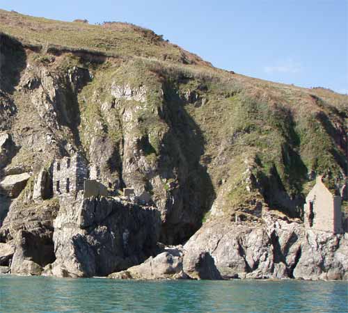
Remains of the village of Hallsands on the discontinuous mica schist platform. Towering above the village are coastal cliffs formed in Start Mica Schist and capped by head deposits. At high tide the waves break against the base of the rock platform.
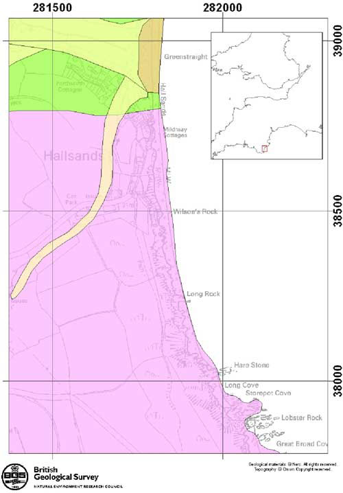
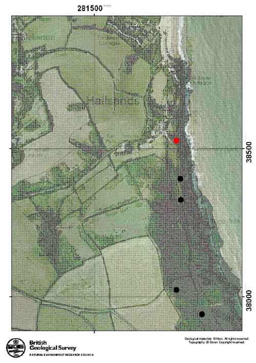
Location of Hallsands, South Devon and 1:50 000 Bedrock and Superficial Geology (Light brown= alluvium, dark brown= beach deposits, green= Start Horneblende Schist, Pink= Start Mica Schist). The area is also capped by significant thicknesses of head deposits (not shown on map). BGS © UKRI.
Sequence of events
The landslide of 6 May 2012 is believed to have been caused by a combination of:
- Wave action that gradually eroded the rock platform, undercutting the overlying head deposits (causing the cave in the pictures) in the vicinity of the stone barn.
- Prolonged heavy rainfall, which reduced the stability of the overlying head deposits. These factors led to planar sliding of the head slope adjacent to the stone barn.
The intact stone barn in 2009. Note the remnants of the old village access road in front of the barn. The current access road runs behind the barn. BGS © UKRI.
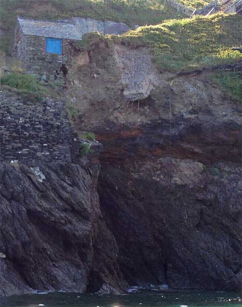
The collapsed barn and landslide scar in May 2012. A cave extending underneath the stone barn and landslide can clearly be seen. BGS © UKRI.
The ruined village
Hallsands has a long history of coastal erosion and the landslide of May 2012 is the latest in a series of events affecting the area. Originally, an entire village was built upon the rock platform, as can be seen in the maps and photos. The ravines now evident between the promontories of the rock platform were originally filled with sand and gravel and a wide beach existed seaward of the platform.
In 1897, the Board of Trade licensed the removal of material from the intertidal zone of Hallsands beach (May and Hansom, 2003). Up to 1600 tonnes of sand and gravel were removed each day for the extension of the Royal Dockyard at Devonport. By 1902, the beach level is estimated to have been lowered by 3 m, and by 6 m in 1904. During this period, 97 per cent of the former beach volume had been removed. Storms in 1900 and 1901 undermined sea walls and eroded sand and gravel from the rock ravines lying behind them. Buildings situated at these points collapsed.
On 26 January 1917, a north-easterly gale with waves over 12 m in height combined with a high tide to destroy 29 houses and lower the beach level by a further 2 m. The effect of the storm is likely to have been exacerbated by the lowering of the beach between 1897 and 1917 following gravel extraction and also by the presence of Skerries Bank (an offshore sand bank), which focused wave energy on the Hallsands area (May and Hansom, 2003).
Only two houses, occupied as holiday homes, now remain.
Coastal erosion at Hallsands
In more recent times, coastal erosion by small cliff collapse is more common. Evidence for this can be seen in the small planar slides and rock falls recorded in the BGS National Landslide Database and in photographic surveys of the area.
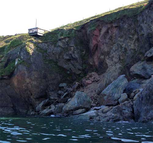
Large rockfall to north of village viewing platform. The landslide scar and debris can be clearly seen from the water. The village access road originally passed seaward of the viewing platform and debris from is visible amongst the boulders on the beach. BGS © UKRI.
Rockfall to south of May 2012 landslide. Boulders of mica schist derived from the cliff can be seen resting on the rock platform amongst the ruins of the village. The overlying head deposits were also undermined but these have since been removed by rainfall and wave action. BGS © UKRI.
References and further reading
May, V J, and Hansom, J D. 2003. Coastal Geomorphology of Great Britain, Geological Conservation Review Series, No. 28. (Peterborough, UK: Joint Nature Conservation Committee.)
You may also be interested in

Landslide case studies
The landslides team at the BGS has studied numerous landslides. This work informs our geological maps, memoirs and sheet explanations and provides data for our National Landslide Database, which underpins much of our research.

Understanding landslides
What is a landslide? Why do landslides happen? How to classify a landslide. Landslides in the UK and around the world.

How to classify a landslide
Landslides are classified by their type of movement. The four main types of movement are falls, topples, slides and flows.

Landslides in the UK and around the world
Landslides in the UK, around the world and under the sea.