On 24 April 2016, the BGS Landslide Response Team received reports of a landslide on a 35 m-high section of the East Cliff in Bournemouth, Dorset. It was reported that the landslide had damaged an Edwardian funicular railway as well as a toilet block and an array of fences and benches from the top of the cliff.
- Bournemouth cliff ‘may have to be regraded’ following landslip BBC, 28 April 2016
- Bournemouth East Cliff landslip crushes toilets BBC, 24 April 2016
- Drone footage BBC, 25 April 2016
- PICTURES: toilets, cliff path and steps destroyed in East Cliff collapse close to Jon Egging Memorial Bournemouth Daily Echo, 25 April 2016
The Landslide Response Team carried out a walkover survey of the site on 27 April 2016. Data collected from this survey is logged in the BGS National Landslide Database (NLD 20108/1).
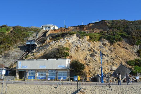

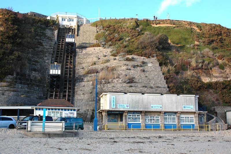
Landslide at East Cliff, Bournemouth, 24 April 2016. East Cliff lift (funicular) on far left, café on left and destroyed toilet on right. Undercliff Drive in foreground. BGS © UKRI.
The landslide
The landslide occurred on Sunday 24 April 2016 at approximately 05:00 on a section of East Cliff approximately 35 m high with an overall angle (unslipped) of about 36 degrees.
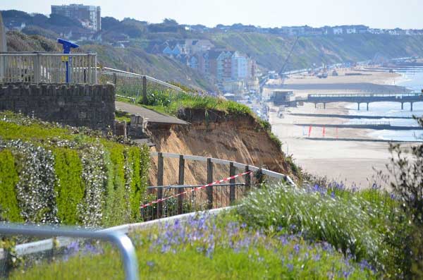
On the previous day, cracks adjacent to the lift structure were reported and Bournemouth Borough Council cordoned off the area, both at the cliff top (including a section of East Overcliff Drive) and on Undercliff Drive at the foot of the cliff. During the visit it was not possible to access the landslide itself or its immediate environs due to the cordon.
Backscarp of the East Cliff landslide, Bournemouth, 24 April 2016. BGS © UKRI.
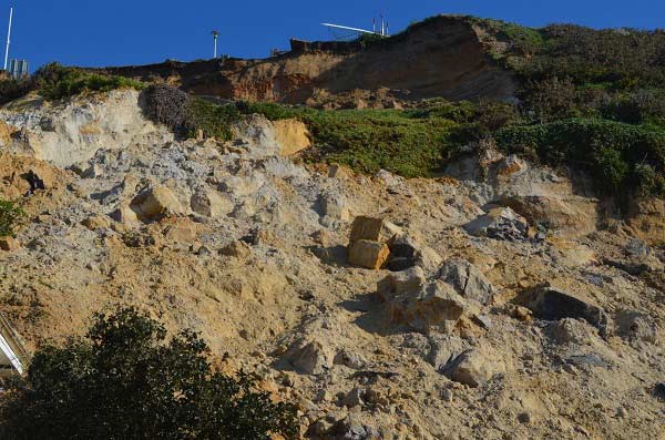
The slip mass of the East Cliff landslide, Bournemouth, 24 April 2016. BGS © UKRI.
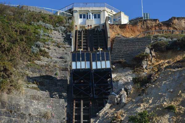
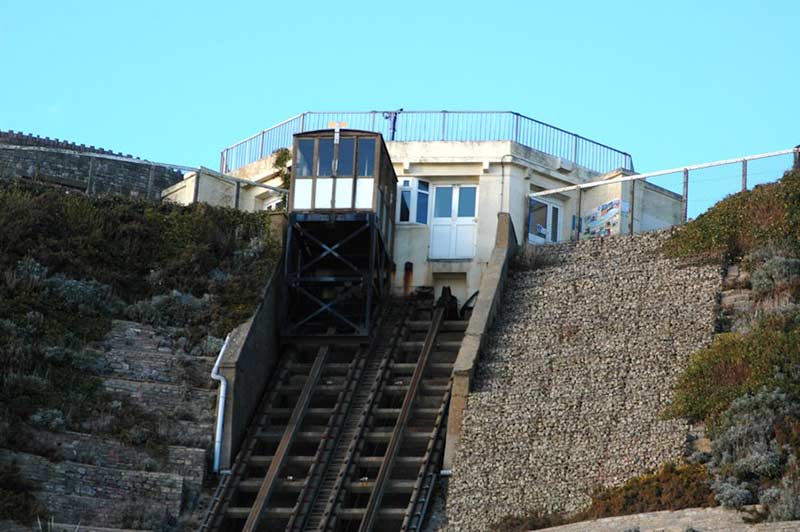
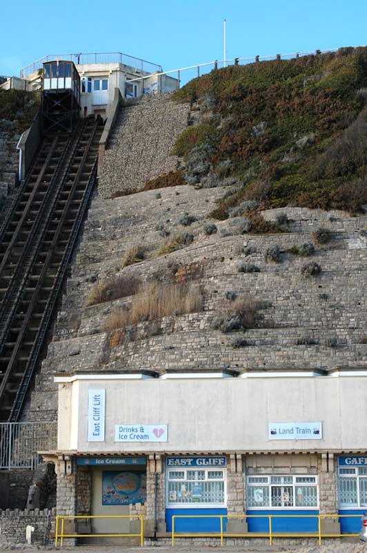
East Cliff lift funicular railway, constructed 1908, after the landslide, Bournemouth, 24 April 2016. BGS © UKRI.
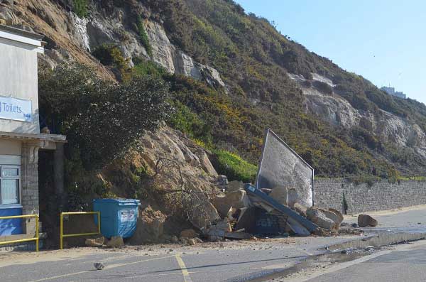
Toe of the landslide at East Cliff, Bournemouth, showing the toilet block, 24 April 2016. BGS © UKRI.
The landslide is one of partial rotation, and possibly translation, with debris flows in the central and lower parts. A steep backscarp remains and a small secondary slip mass was seen at the upper eastern side of the main slip mass.
The landslide split either side of the café block (which remained intact) forming two masses of material. The slip masses contain several large boulders up to approximately 2 × 1 × 1 m. The larger, eastern mass progressed further downslope than the western mass due to the destruction of the toilet block. The slip mass as a whole appeared potentially unstable and further movements were considered likely.
Little revetment masonry from the flanks of the East Cliff lift (constructed 1908) was evident in the landslide, though the eastern flank had dropped several metres leaving the concrete wall exposed. It is therefore possible that the landslide had overridden the bulk of the masonry on the central and lower parts of the slope.
The lower part of the lift track had been overridden by the landslide and the eastern of the two cable vehicles was affected, though they both remain in place. The western end of the upper part of the landslide had been curtailed by the concrete wall running along the trackside, thus effectively forming a western sidescarp.
What appeared to be clean water was seen emerging from the destroyed toilet block onto the road. This is assumed to be from a fractured water supply pipe within the toilet block. No water was observed emerging from the landslide itself, although access onto the landslide was not possible and hence the presence (or absence) of water within the landslide could not be confirmed.
A small landslide occurred at the location of the toilet block in 2008, destroying the previous block. The block now destroyed was its replacement.
There is no evidence that this landslide is the result of recent beach dynamics.
Geology
The geology of the cliffs at East Cliff comprise a sequence of generally very weak sandstones and mudstones from the middle Eocene belonging to the Boscombe Sand Formation and the underlying Branksome Sand Formation.

Geological map showing Boscombe Sand Formation (BOSS) and Branksome Sand Formation (BRKS). Contains Ordnance Data © Crown Copyright and database rights 2013. Ordnance Survey Licence no. 100021290.
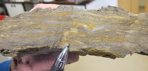
Example of Branksome Sand Formation bedding. Specimen taken from landslide debris. Thinly interbedded/laminated silty sands and silty clays, with a sand-filled drying (?) fissure. BGS © UKRI.
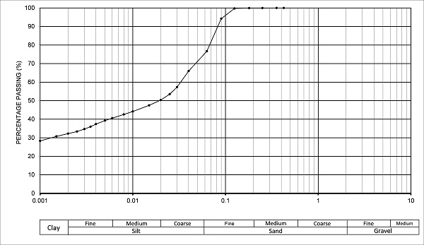
Particle size chart for Branksome Sand Formation sample. Note dominance of coarse silt/very fine sand. BGS © UKRI.
The laminated and thinly bedded rocks of the Branksome Sand Formation are susceptible (in water) to slaking and possibly have a tendency towards liquefaction resulting in total breakdown of the fabric. This is facilitated by the lack of cementation within the sand/silt component and possibly by shrink–swell action (on wetting) within the clay component. This gives the Branksome Sand a rating of ‘unstable’ in the ‘rock material stability in water’ classification (BS EN ISO 14689-1).
The particle size chart shows the dominance of very fine silt and coarse sand with a significant clay content (sand: 23.3 per cent; silt: 44.5 per cent; clay: 32.2 per cent).
The intimate juxtaposition of sand and clay, characteristic of the Branksome Sand Formation, allows rapid movement of water through the rock mass and exposure of the clay component to water and hence shrink–swell deformation and cracking. These conditions are likely to have contributed to the development of a landslide shear plane within the Branksome Sand Formation, which has migrated upward to the cliff top forming a continuous surface.
Photographs from before the landslide
Tim Cullen, previously senior photographer at BGS, kindly contacted us with some photographs he took in February 2016, before the landslide in April.
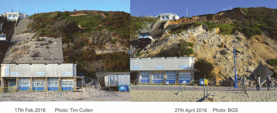
Before and after photographs of the landslide at East Cliff, Bournemouth. Left photograph courtesy of and © Tim Cullen. Right photograph BGS © UKRI.
Photograph of the section of cliff before the landslide took place. Photograph courtsey of and ©Tim Cullen, taken in February 2016.
Photograph of the top of the funicular railway before the landslide took place. Photograph courtsey of and ©Tim Cullen, taken in February 2016.
Photograph of the section of cliff and the funicular railway before the landslide took place. Photograph courtsey of and ©Tim Cullen, taken in February 2016.
You may also be interested in

Landslide case studies
The landslides team at the BGS has studied numerous landslides. This work informs our geological maps, memoirs and sheet explanations and provides data for our National Landslide Database, which underpins much of our research.

Understanding landslides
What is a landslide? Why do landslides happen? How to classify a landslide. Landslides in the UK and around the world.

How to classify a landslide
Landslides are classified by their type of movement. The four main types of movement are falls, topples, slides and flows.

Landslides in the UK and around the world
Landslides in the UK, around the world and under the sea.