Funding secured to help mitigate ground risk in UK construction sector
The BGS Common Ground project has been awarded new funding to help unlock the value of ground investigation data.
05/02/2026 By BGS Press

Ground investigation (GI) work is routinely carried out to assess ground conditions and identify ground hazards prior to the construction of new buildings and infrastructure projects. The UK construction sector invests approximately £1.2 billion per year in GI, yet unforeseen ground conditions still cause significant delays and overspend, estimated at 10 per cent of project costs or £120 million per year.
Additional funding has been secured from the Government Office for Technology Transfer to expand BGS’s pioneering Common Ground project. This initiative aims to develop a national geotechnical properties data service, maximising the return on GI investment and reducing risk, increasing efficiency and unlocking the value of GI data for the UK construction sector.
Following the success of the project’s first phase, the new funding will enable BGS to build on pilot geotechnical data tools that were developed for Glasgow to deliver a national-scale geotechnical data service that combines geotechnical data with geological knowledge.

As BGS moves forward with this exciting phase, we remain committed to delivering solutions that maximise the return on investment in GI data, reduce carbon emissions and support a more resilient and efficient construction industry.
Alison Steven, data operations and governance manager at BGS.
Ensuring that users remain at the heart of product development, our partners, Difference Engine, will be conducting further market research and will develop a strategy to help BGS provide an authoritative data service with the functionality that suits the end user.
The knowledge asset underpinning this project, the BGS National Geotechnical Properties Database (NGPD), contains data from approximately 200 000 boreholes, consolidated, validated and verified by BGS experts.
If you are a user or producer of GI data and would like to be involved in the project please get in touch with the Common Ground team.
Relative topics
Related news

New geological maps of Berwick-upon-Tweed to help future-proof natural water supply
20/05/2026
Scientists have mapped the geology under the town to better understand the groundwater system to inform decisions around abstraction.
BGS GeoClimate – dataset launch webinar
Event on 02/06/2026
The virtual launch of our new BGS GeoClimate dataset – helping mitigate the economic risk from shrink-swell subsidence. Event recording now available

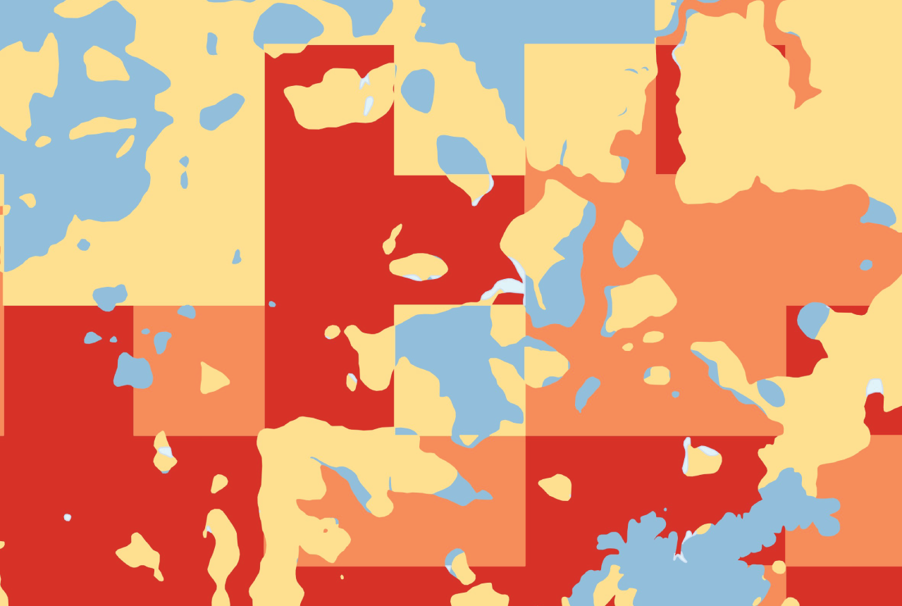
Map of BGS BritPits showing the distribution of worked mineral commodities across the country
18/02/2026
BGS’s data scientists have generated a summary map of the most commonly extracted mineral commodities by local authority area, demonstrating the diverse nature of British mineral resources.
Funding secured to help mitigate ground risk in UK construction sector
05/02/2026
The BGS Common Ground project has been awarded new funding to help unlock the value of ground investigation data.

New geological maps of the Yorkshire Wolds to better inform groundwater management and policy decisions
17/12/2025
The new mapping provides crucial data on localised geological issues that may assist in protecting water supplies.

Latest BGS Geology 50K mapping data launched
06/11/2025
Some of our most widely used maps have received a major update, including the 1:50 000-scale map series that now includes enhanced coverage of Great Britain.

World Cities Day: the geological story of our cities
31/10/2025
Understanding the rocks that underlie our towns and cities, the risks they can present and how they influence urban planning and redevelopment.

New BGS GeoIndex viewer released for user testing
24/09/2025
The premium map-viewing application has been given a major upgrade and made available as a beta release.

New seabed sediment maps reveal what lies beneath the waves
03/09/2025
Marine ecosystem science and offshore infrastructure will be boosted by a new dataset showing sediment composition across the UK continental shelf.
BGS digital geology maps: we want your feedback
29/05/2025
BGS is asking for user feedback on its digital geological map datasets to improve data content and delivery.
New data reveals latest mineral workings around Great Britain and Northern Ireland
01/04/2025
The newest release of BGS BritPits provides information on an additional 6500 surface and underground mineral workings.
Seabed geology data: results from stakeholder consultation
31/01/2025
BGS collected valuable stakeholder feedback as part of a new Crown Estate-led initiative to improve understanding of national-scale seabed geology requirements.