Perth and Kinross tops the UK’s earthquake activity charts for 2025
Seismologists at BGS have published data on the number of seismic events over the past 12 months with over 300 earthquakes recorded.
29/12/2025 By BGS Press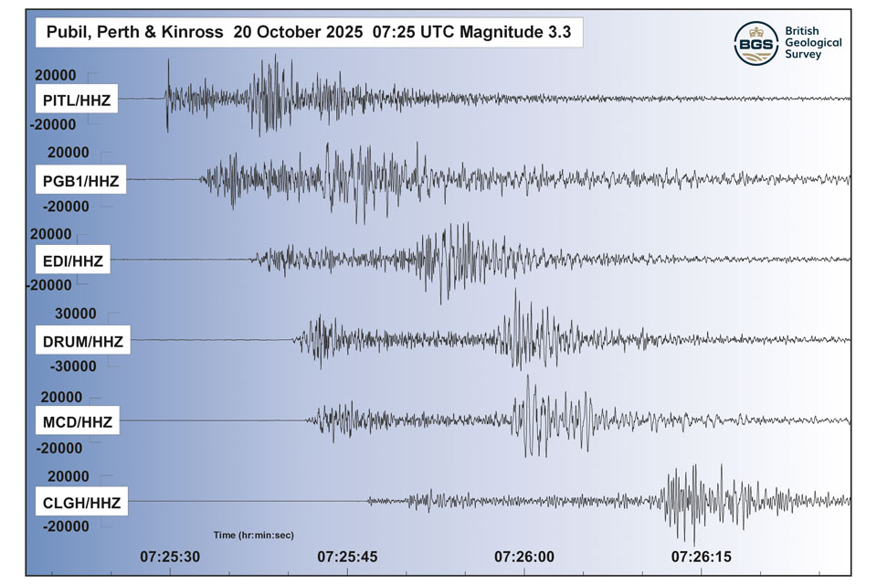

As of mid-December, 2025 has seen 309 earthquakes recorded across the UK so far. The most active regions included Perthshire and the western Highlands in Scotland, Lancashire and Yorkshire in England, and southern parts of Wales.
Whilst many of these seismic events were too subtle to be felt by members of the public, the network of 80 monitoring stations across the UK operated by the British Geological Survey (BGS) has been recording the movement beneath our feet to an exceptional level of accuracy.
BGS is the national body responsible for recording earthquakes and our annual snapshot of UK earthquake data, published today, shows 2025 has proven above average for earthquakes across the UK.
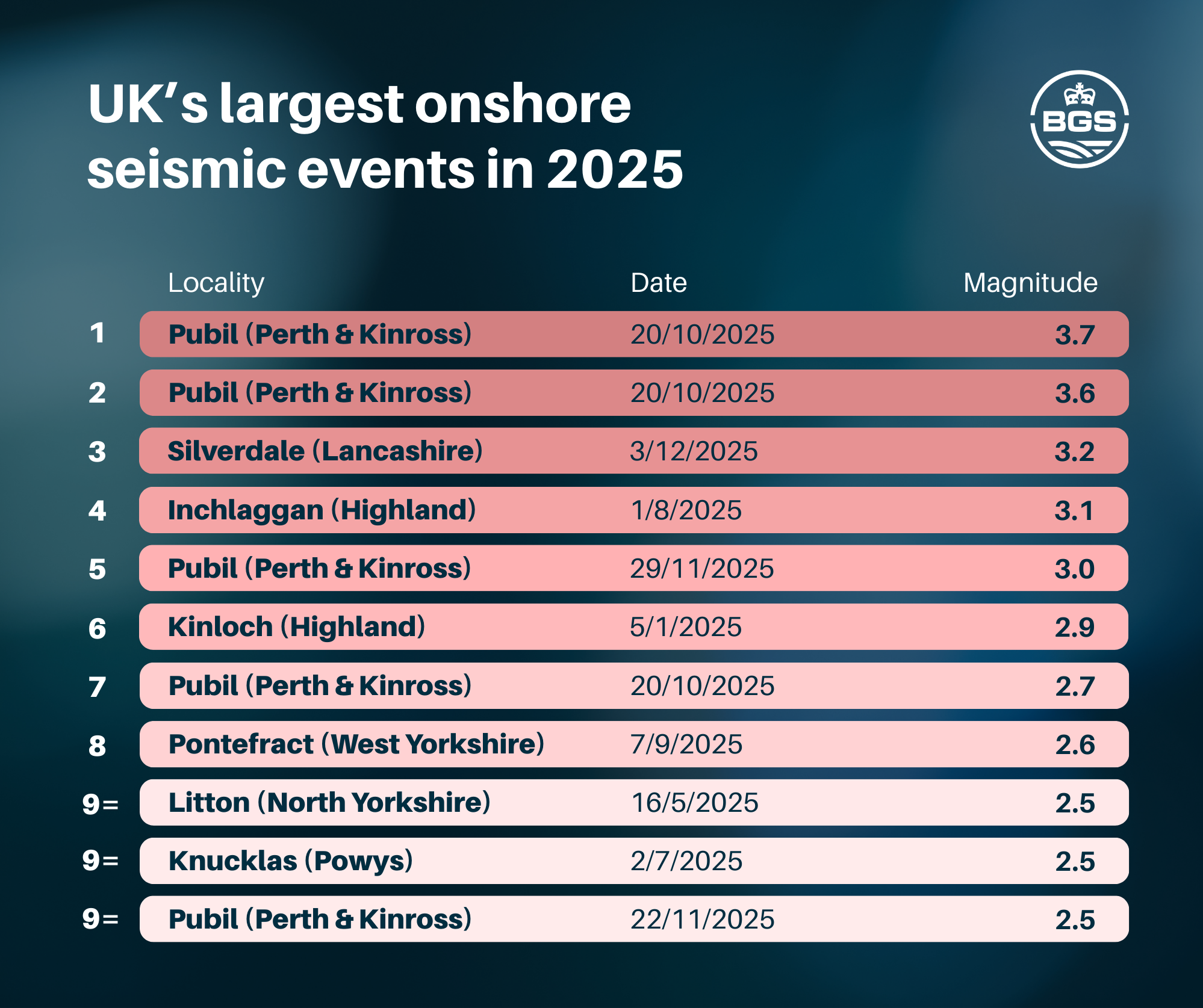
Thirty-four of the earthquakes occurred near Loch Lyon in Perth and Kinross between October and December. This includes the two largest onshore earthquakes, which occurred just hours apart on 20 October. A magnitude 3.7 quake was followed by one of magnitude 3.6, with local residents reporting the experience as though ‘a large lorry had crashed’ or ‘like an underground subway under my house’; another stated that ‘the house shook and all the windows rattled’. BGS received 198 ‘felt reports’ following the event, some more than 60 km from the epicentre. A magnitude 3.2 earthquake in Lancashire in early December was even more widely felt, with nearly 700 felt reports submitted.
In total, BGS received 1320 reports from members of the public who felt earthquakes this year. This vital ‘citizen science’ allows us to collect important contextual data around each event, including effects at the surface such as noise or levels of shaking.

The data shows that earthquakes occurred in many parts of Great Britain over the past 12 months, with numerous events in Scotland, England and Wales that were each significant enough to be widely felt by many nearby.
Whilst thankfully major earthquakes of devasting magnitude are extremely unlikely, the country on average experienced an earthquake almost once a day this year.
It is a reminder that small earthquakes happen all the time and it remains of critical importance that they are studied to help us understand the possible impact of the rare large earthquakes on major energy and infrastructure projects around the country.
Dr Brian Baptie, BGS seismologist
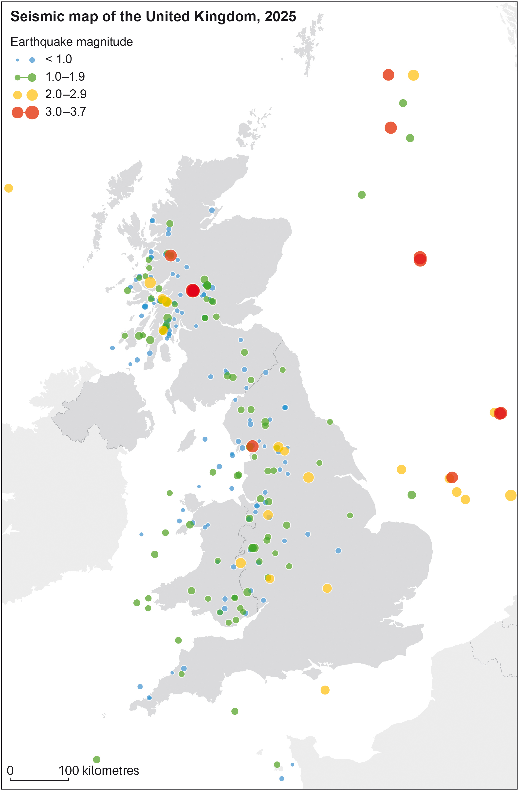
Distribution of earthquakes in 2025. BGS © UKRI
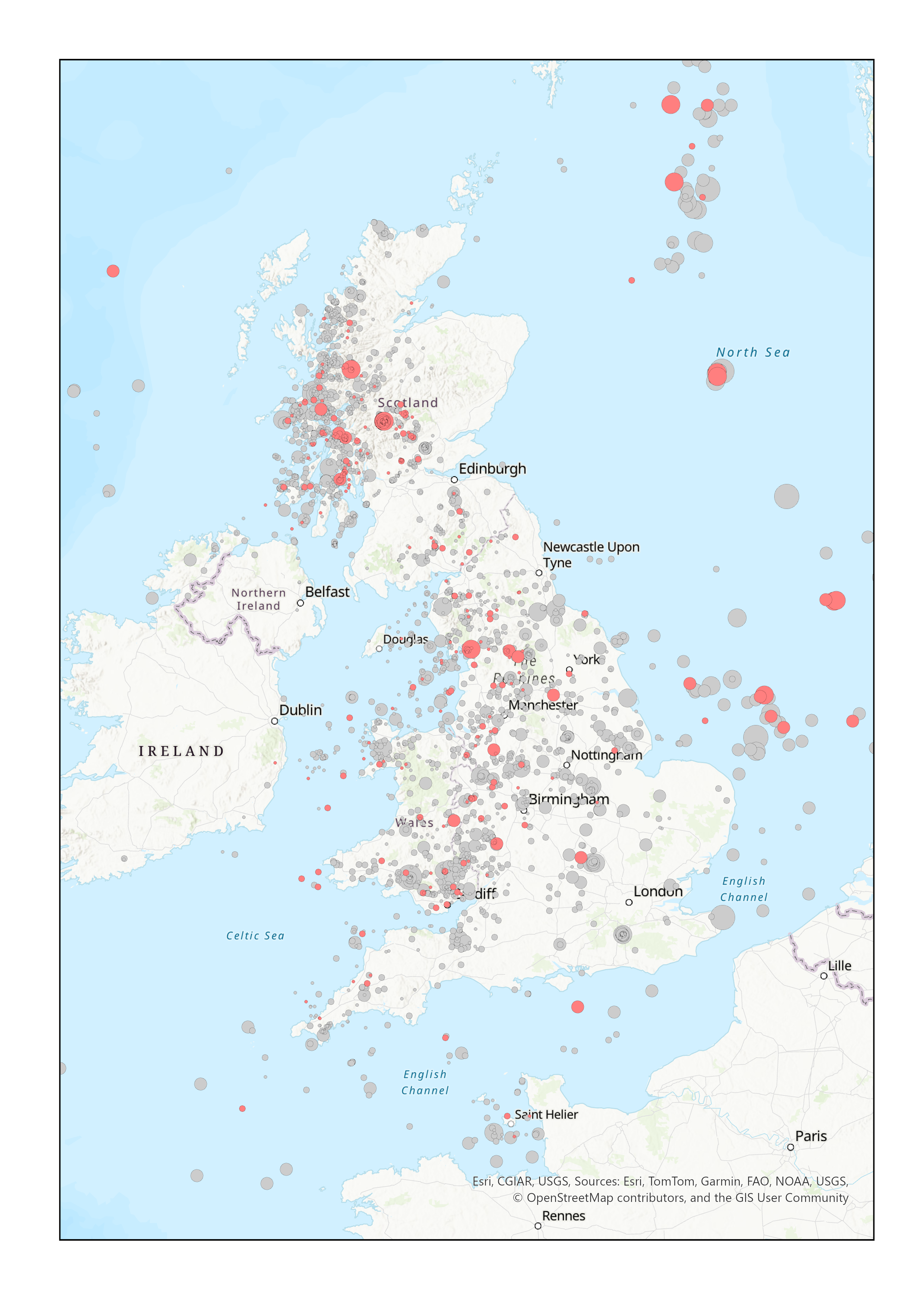
Distribution of 2025 earthquakes (red) superimposed on seismic activity recorded over the last 10 years (grey). BGS © UKRI.
Although the magnitude of many of these earthquakes is too low to be felt by humans, the largest seismic events observed in the UK, with magnitudes in the range of 5 to 6, can pose a threat. This research, which is in part publicly funded through UK Research and Innovation, helps improve understanding of seismic risk around the country and is crucial information for the Government, industry and regulators, in order to mitigate the threat to buildings and infrastructure.
Dr Baptie says it makes sense that Perth and Kinross tops the list of seismic activity across 2025.
The west of Scotland is one of more active parts of the UK. Some of this activity can be attributed to well-known geological faults like the Great Glen Fault and the Highland Boundary Fault. By contrast, north-east Scotland experiences very few earthquakes.
Dr Brian Baptie, BGS seismologist
In addition to naturally occurring events, induced seismicity (such as sonic booms) that are caused by human activity are also recorded in the data. These readings are kept as part of a BGS archive of continuous ground-motion recordings, dating back over several decades.
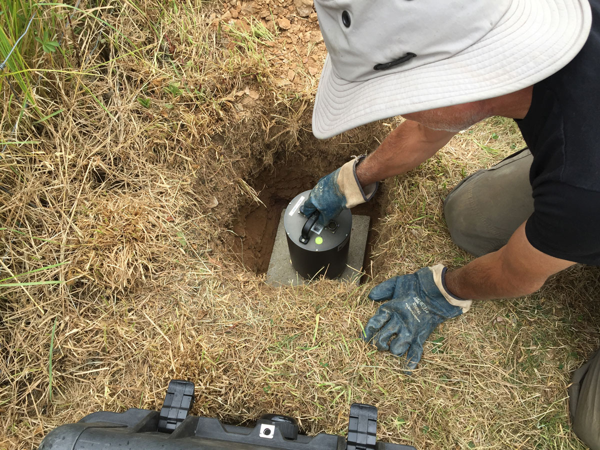
BGS scientist installing seismic monitoring equipment. BGS © UKRI
The Richter scale, which is used to accurately record and compare earthquakes, is a logarithmic scale and not linear. Each order of magnitude is 32 times more intensive than the last one. In other words, a magnitude 2 earthquake is 32 times more intense than one of magnitude 1 and a magnitude 3 is almost 1000 times greater. As you progress up through the scale, vast amounts of energy are being unleashed under the ground, which is why some earthquakes can have such a devastating impact.
Although larger earthquakes in our region are rare, they do occur. Great Britain and the surrounding areas typically experience a magnitude 4 event every three to four years, a magnitude 5 event every few decades with the most recent being in Lincolnshire in 2008, and a magnitude 6 every few hundred years. An event of this scale was last recorded in the North Sea in 1931. Although infrequent, the fact that such large events can happen means it is vital that earthquakes are studied over the long term so that an accurate picture of the risk around the country can be stablished.
Further information, including a live feed of recent UK earthquakes, is available on the BGS website.
Relative topics
Related news

Isotopes and science: my student placement at BGS
08/04/2026
Industrial placements at BGS for undergraduate students give real-life experience of working in laboratories and learning different analytical techniques.

Updated geological assessment of the Southern North Sea set to underpin future offshore infrastructure development
25/03/2026
The first regional assessment for 30 years will support offshore marine and subsurface planning for the UK’s low-carbon energy infrastructure, including the 2030 target of 45 to 50 GW generated through offshore wind.

New research could help provide a more reliable water supply for millions in rural Africa
24/03/2026
A new BGS-led study has revealed crucial insights into the longstanding challenges affecting the reliability and performance of rural water supply infrastructure in sub-Saharan Africa.

Call for new members and Chair to join the NERC facilities steering committees
25/02/2026
New members are needed to join the committees over the next four years.

Your views wanted: developing a geothermal energy subsurface data portfolio
24/02/2026
BGS is aiming to support the growth of the sector by providing the best-available, location-specific geothermal and ground source heat information as an accessible product or service.

Map of BGS BritPits showing the distribution of worked mineral commodities across the country
18/02/2026
BGS’s data scientists have generated a summary map of the most commonly extracted mineral commodities by local authority area, demonstrating the diverse nature of British mineral resources.

Funding awarded to map the stocks and flows of technology metals in everyday electronic devices
12/02/2026
A new BGS project has been awarded Circular Electricals funding from Material Focus to investigate the use of technology metals in everyday electrical items.

New UK/Chile partnership prioritises sustainable practices around critical raw materials
09/02/2026
BGS and Chile’s Servicio Nacional de Geología y Minería have signed a bilateral scientific partnership to support research into critical raw materials and sustainable practices.

Extensive freshened water confirmed beneath the ocean floor off the coast of New England for the first time
09/02/2026
BGS is part of the international team that has discovered the first detailed evidence of long-suspected, hidden, freshwater aquifers.

Funding secured to help mitigate ground risk in UK construction sector
05/02/2026
The BGS Common Ground project has been awarded new funding to help unlock the value of ground investigation data.

Can sandstones under the North Sea unlock the UK’s carbon storage potential?
02/02/2026
For the UK to reach its ambitious target of storing 170 million tonnes of carbon dioxide per year by 2050, it will need to look beyond the current well-studied geographical areas.

Quaternary UK offshore data digitised for the first time
21/01/2026
The offshore wind industry will be boosted by the digitisation of a dataset showing the Quaternary geology at the seabed and the UK’s shallow subsurface.