New tool provides users with free access to geological models for three major UK cities
A new tool providing free user access to 3D geological models has been added to the GeoIndex.
18/11/2021 By BGS Press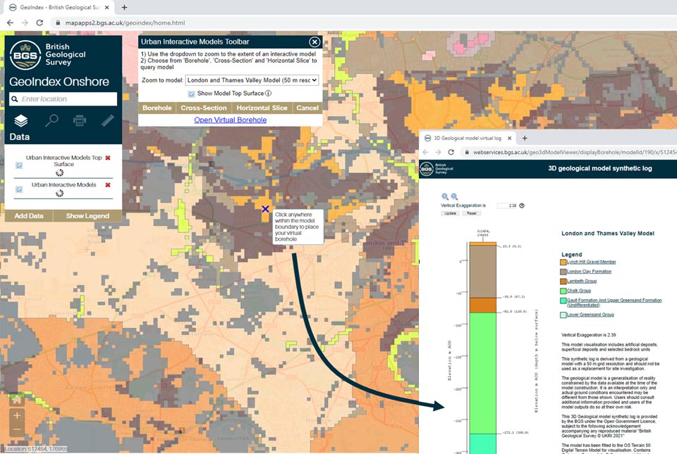

A new urban interactive models tool, providing free user access to geological models for selected UK cities, has been added to BGS’s GeoIndex service.
BGS GeoIndex already provides access to a range of 2D information and data resources through an interactive map viewer, enabling users to navigate to their area of interest, view and query datasets, download reports and clip data, and make enquiries.
The new tool allows users to capture synthetic boreholes, geological cross-sections and slices through 3D models developed by BGS for London, Glasgow and Cardiff, the largest cities in England, Scotland and Wales.
A range of technical, professional and academic users, in particular consultancy for the geotechnical, construction and groundwater sectors, will benefit from the tool, which makes key urban models freely accessible for the first time.
The models provide regional geological understanding (50 m resolution) designed to help users develop conceptual ground models and plan ground investigations.
Users can query the geological model to obtain a range of visualisations of geological conditions beneath each of the cities. The views can also be downloaded as a standard format PDF.

3D urban geology on the BGS GeoIndex. BGS © UKRI.
Each of the geological models was constructed through the analysis of thousands of borehole records and integration with geological map data, informed by extensive literature review. In addition to the virtual borehole and section functions, a new slice function is being trialled for displaying geological units at specified depths.
Katie Whitbread, who leads the national geological modelling programme at the BGS, said the tool helps inform the development of conceptual ground models for construction and groundwater management, as well as supporting early-stage planning.

Urban geological models encapsulate a huge amount of geological data and knowledge to provide comprehensive 3D information on the variability of the rocks and sediments underlying our cities. Understanding this variability is critical for de-risking decision making and investment in a range of applications from construction to the management of surface and groundwater.
Conceptual ground models are a key component of early planning and desktop studies, helping to identify potential risks, develop hypotheses around ground conditions, optimise the design of targeted investigations and allow communication of the geological conditions to different stakeholders.
The urban interactive model tool adds value to the initial stages of this development process, providing accessible regional geological understanding for key UK cities, derived directly from three-dimensional geological characterisation of the upper few 100 m of the ground.
Katie Whitbread, project manager, BGS National Geological Model.
Through the tool, users can link to other BGS resources including the lexicon, model metadata reports and relevant research reports for the selected cities, and access wider 2D and 3D data services.
The underlying model data, along with a range of other BGS LithoFrame models, can be licensed through BGS Data Services, who can also arrange academic licences. BGS also provides bespoke modelling services and commissioned research for users requiring access to more detailed information. Users are encouraged to provide feedback by email to BGS Enquiries and are invited to get in touch if they are interested in being part of a user forum to help inform the design and development of new features and functions.
Whilst the tool is not intended to provide a substitute for detailed site investigations and we recognise these evaluations require additional information, the geological model provides a baseline dataset and regional context that, crucially, can inform early decision making, particularly at the desk study stage.
We are committed to working closely with potential users and stakeholders to develop the model and explore how BGS can advance its 3D geology services to help support planning and resource assessments.
Working with our stakeholders, we would like to explore future development of the tool such as increasing the coverage of UK urban areas, adding geotechnical and hydrogeological information and providing additional digital output formats so that GeoIndex continues to provide subsurface knowledge where it is needed most.
Katie Whitbread, project manager, BGS National Geological Model.
The new tool can be accessed by opening the onshore GeoIndex online and navigating to the new ‘3D models’ layer, under the data list.
Relative topics
Related news
UK Minerals Yearbook 2025 now available
21/04/2026
The annual publication provides essential information about the production, consumption and trade of UK minerals up to 2025.

UK scientists unite for seabed mapping survey of the UK’s south-west coastline
15/04/2026
BGS geologists join research voyage, gathering crucial geological data to support offshore energy and infrastructure projects.

Isotopes and science: my student placement at BGS
08/04/2026
Industrial placements at BGS for undergraduate students give real-life experience of working in laboratories and learning different analytical techniques.

Updated geological assessment of the Southern North Sea set to underpin future offshore infrastructure development
25/03/2026
The first regional assessment for 30 years will support offshore marine and subsurface planning for the UK’s low-carbon energy infrastructure, including the 2030 target of 45 to 50 GW generated through offshore wind.

New research could help provide a more reliable water supply for millions in rural Africa
24/03/2026
A new BGS-led study has revealed crucial insights into the longstanding challenges affecting the reliability and performance of rural water supply infrastructure in sub-Saharan Africa.

Call for new members and Chair to join the NERC facilities steering committees
25/02/2026
New members are needed to join the committees over the next four years.

Your views wanted: developing a geothermal energy subsurface data portfolio
24/02/2026
BGS is aiming to support the growth of the sector by providing the best-available, location-specific geothermal and ground source heat information as an accessible product or service.

Map of BGS BritPits showing the distribution of worked mineral commodities across the country
18/02/2026
BGS’s data scientists have generated a summary map of the most commonly extracted mineral commodities by local authority area, demonstrating the diverse nature of British mineral resources.

Funding awarded to map the stocks and flows of technology metals in everyday electronic devices
12/02/2026
A new BGS project has been awarded Circular Electricals funding from Material Focus to investigate the use of technology metals in everyday electrical items.

New UK/Chile partnership prioritises sustainable practices around critical raw materials
09/02/2026
BGS and Chile’s Servicio Nacional de Geología y Minería have signed a bilateral scientific partnership to support research into critical raw materials and sustainable practices.

Extensive freshened water confirmed beneath the ocean floor off the coast of New England for the first time
09/02/2026
BGS is part of the international team that has discovered the first detailed evidence of long-suspected, hidden, freshwater aquifers.

Funding secured to help mitigate ground risk in UK construction sector
05/02/2026
The BGS Common Ground project has been awarded new funding to help unlock the value of ground investigation data.