New BGS GeoIndex viewer released for user testing
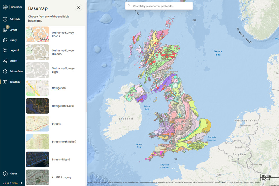
The premium map-viewing application has been given a major upgrade and made available as a beta release.
24/09/2025 By BGS Press
First launched in July 2000, the BGS GeoIndex is a professional digital geological map application and receives over one million views each year.
The current iterations of the GeoIndex Onshore and GeoIndex Offshore applications are now 10 years old and approaching the end of their technical lifespans. The transition to the updated viewer has allowed us to unify the platforms into a single, streamlined tool and increase awareness of the geological data available from BGS.
Alongside the integration of onshore and offshore data, the new GeoIndex beta release includes a number of other notable additions. The refreshed and upgraded user interface has been designed to enhance the user experience, with improved find and filter tools to make it easier to access the relevant data. Direct links to full Discovery Metadata records have been added to provide deeper insights and there are expanded basemap options, including the latest Ordnance Survey maps and high-resolution satellite imagery.
The beta release also includes core geological data layers, such as 625K- and 50K-scale digital geological mapping and borehole datasets, to allow for focused user testing. We are looking at eventually streamlining some of the other currently available data layers as part of the review, to ensure the new platform is as user friendly as possible.
The BGS GeoIndex is our flagship map viewer and we’ve spent the last few years planning how we can improve the application for our users.
We are excited to share this beta version for testing and to gauge users’ reactions and hope the updated interface will bring many welcome usability improvements.
Steven Richardson, BGS Geospatial Applications Developer.
We would welcome user feedback during this beta phase, and comments can be submitted through the GeoIndex online feedback form.
Please note: commercial, research and public good level users should continue to use the existing BGS GeoIndex (onshore) and GeoIndex (offshore) applications for professional use until the new platform is formally launched.
Relative topics
Related news

Funding awarded to map the stocks and flows of technology metals in everyday electronic devices
12/02/2026
A new BGS project has been awarded Circular Electricals funding from Material Focus to investigate the use of technology metals in everyday electrical items.

New UK/Chile partnership prioritises sustainable practices around critical raw materials
09/02/2026
BGS and Chile’s Servicio Nacional de Geología y Minería have signed a bilateral scientific partnership to support research into critical raw materials and sustainable practices.

Extensive freshened water confirmed beneath the ocean floor off the coast of New England for the first time
09/02/2026
BGS is part of the international team that has discovered the first detailed evidence of long-suspected, hidden, freshwater aquifers.

Funding secured to help mitigate ground risk in UK construction sector
05/02/2026
The BGS Common Ground project has been awarded new funding to help unlock the value of ground investigation data.

Can sandstones under the North Sea unlock the UK’s carbon storage potential?
02/02/2026
For the UK to reach its ambitious target of storing 170 million tonnes of carbon dioxide per year by 2050, it will need to look beyond the current well-studied geographical areas.

Quaternary UK offshore data digitised for the first time
21/01/2026
The offshore wind industry will be boosted by the digitisation of a dataset showing the Quaternary geology at the seabed and the UK’s shallow subsurface.

Suite of ten new soil reference materials released
02/01/2026
BGS has a longstanding track record of producing high-quality reference materials and has released ten new soil reference materials.

Perth and Kinross tops the UK’s earthquake activity charts for 2025
29/12/2025
Seismologists at BGS have published data on the number of seismic events over the past 12 months with over 300 earthquakes recorded.

BGS awarded funding to support Malaysia’s climate resilience plan
17/12/2025
The project, funded by the Foreign, Commonwealth & Development Office, will focus on minimising economic and social impacts from rainfall-induced landslides.

New geological maps of the Yorkshire Wolds to better inform groundwater management and policy decisions
17/12/2025
The new mapping provides crucial data on localised geological issues that may assist in protecting water supplies.

‘Three norths’ set to leave England and not return for hundreds of years
12/12/2025
The historic alignment of true, magnetic, and grid north is set to leave England, three years after they combined in the country for the first time since records began.

BGS agrees to establish collaboration framework with Ukrainian government
11/12/2025
The partnership will focus on joint research and data exchange opportunities with Ukrainian colleagues.


