Natural flood management: is geology more important than trees?
Looking at innovative ways of creating resilience to flooding hazards with natural flood management.
23/11/2023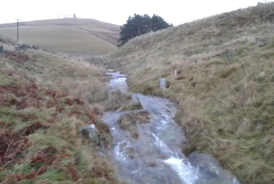


View of the Eddleston Natural Flood Management demonstration and research site in the Scottish Borders. This is one of a global network of UNESCO Ecohydrology Demonstration Sites. © Leo Peskett / Heriot Watt
Natural flood management (NFM) has become a key aspect of UK policy to reduce the risk of flooding, a hazard that is expected to increase under future climate-change scenarios.
What is natural flood management?
NFM seeks to control flooding by reducing or slowing the flow in river catchments using natural approaches. These include measures such as:
- planting trees to enhance infiltration and catchment roughness
- installing leaky wooden barriers within streams to create temporary surface water storage
- re-meandering rivers to reconnect them to their flood plains
Current understanding of natural flood management
There is growing pressure to change the way landscapes are managed at large spatial scales to respond to the climate and biodiversity crises. Despite its newfound popularity in UK policy, there are still uncertainties about the effectiveness of NFM at large spatial scales and for large floods. This is particularly true for measures that are dispersed across catchments, such as land-use change through afforestation or improvements to soil quality. Understanding how water is stored and released within catchments is vital for predicting the effects of these changes on both floods and droughts, as well as a host of other co-benefits such as biodiversity and agricultural productivity.
Recent work by Heriot-Watt University, the University of Edinburgh, BGS and the University of Dundee has started to look at these questions at the internationally important UNESCO ecohydrology demonstration site at the Eddleston Water natural flood management research site in the Scottish Borders.
Why is more research needed?
The infiltration of water into the subsurface is a key area of research in NFM including:
- how water infiltrates different soils
- the effect of different soil properties on infiltration rates
- the effect of different land uses on infiltration rates
In addition to understanding how easily water infiltrates, we also need to know how much water can infiltrate and where it goes — in other words, how much water can be stored? There has been much less research on quantifying catchment storage and the role of deeper catchment storage in the context of NFM, despite its potentially fundamental importance to our understanding of hydrology.
The effects of soils and geology on catchment storage
Using multiple methods, including water-level monitoring and stable isotopic tracers, our research estimated water storage across nine subcatchments and correlated the findings with catchment properties such as soil type, land cover and geology. We found that soils and geology dominated plantation forest cover in controlling catchment water storage, suggesting that the effects of changing forest cover are masked by more dominant soil and geological properties.
There are, of course, caveats to the work: we only looked at existing, mature conifer forests and only considered the effect of trees on storage. The impacts of trees on surface roughness and broadleaved trees, which are the main type planted by this and many other NFM projects, were not considered. While the differences are probably minimal, these questions need to be tested through further research. Our findings are, however, consistent with other work looking at land cover and catchment storage and catchment response to storms in Eddleston and elsewhere in Scotland.
Implications for natural flood management
These findings have two significant implications for NFM. The first is to add further criteria for determining the planting of the ‘right trees in the right place’. This storage perspective suggests that tree planting needs to be targeted at areas where potential storage is high but infiltration rates are low, such as highly compacted or degraded soils in relatively permeable catchments. The second is the need to understand dominant catchment controls on runoff in any NFM scheme, which means getting better knowledge of hydrological processes within catchments and their representation within models. We are exploring this second implication in a follow-up study combining stream flow data and water tracer data into a hydrological model, to see if this improves model outputs and therefore understanding of land use change in the catchment.
There is growing pressure to change the way landscapes are managed at large spatial scales to respond to the climate and biodiversity crises. Gaining a better understanding of catchment water storage across different environments is likely to be vital for predicting the multiple benefits and risks of nature-based solutions such as NFM. Future research using both empirical and modelling approaches needs to incorporate these perspectives to underpin effective future management strategies.
About the authors

Prof Alan MacDonald
Head of BGS Groundwater
Leo Peskett
Assistant professor in physical geography
Heriot-Watt University
Leo’s work focuses on evaluating the effectiveness of nature-based solutions in the land and water sectors and engaging with policymakers at international to local levels to bridge research and policy. His recent research has concentrated on:
- the integration of land and water management in the UK
- the impacts of land use on runoff in a natural flood management context
- the use of the natural capital approach in environmental management
Prior to academia, Leo spent a decade heavily involved in the development of global policies to reduce carbon emissions from deforestation (REDD+) and related climate change policies, working with the Overseas Development Institute, UN agencies and governments in the global North and South.
Relative topics
Related news

UK Critical Minerals Intelligence Centre makes recommendations for the next UK criticality assessment
01/07/2026
CMIC has outlined the enhancements made to the next assessment update to ensure it is better tailored to the structure of the UK economy.

From archive to discovery: historical mineral reports support gold exploration in Scotland
25/06/2026
Digitised geological records show potential to unlock untapped mineral resources in Ardlochan, Argyllshire.

UK and Philippines scientists investigate natural hydrogen generation processes at atomic scale
22/06/2026
BGS researchers were granted access to use the Diamond Light Source facility in order to study hydrogen in light brighter than the sun.

Shortage of end-of-life materials presents challenge to UK critical minerals security
17/06/2026
A new report by the UK Critical Minerals Intelligence Centre reveals insufficient end-of-life material stocks present a supply risk over the coming decade, but offer significant long-term potential to meet critical mineral demand through recycling.

UK geothermal catalogue receives update
16/06/2026
BGS releases the second digital version of the UK geothermal catalogue of subsurface temperature and rock thermal conductivity measurements and heat flow calculations.

Scientists make new discovery in the history of the Giant’s Causeway
15/06/2026
New research is changing our scientific understanding of the formation of one of the UK’s most iconic landmarks and has revealed that Northern Ireland’s volcanic past occurred over a much shorter period than previously thought.

Latest research emphasises climate-related subsidence risk to millions of British homes
11/06/2026
New data from BGS highlights the projected future impact of warmer, drier summers and underlines the need for mitigation measures in susceptible regions.

Ukraine and the UK strengthen their commitment to geological cooperation
10/06/2026
A new Memorandum of Understanding reaffirms the UK’s support of Ukraine’s ambitions to develop its critical mineral resources, paving the way for collaboration through capacity-building programmes.
Newly released core could hold clues on potential mineral prospectivity in Perthshire
05/06/2026
A comprehensive collection of geological samples from the vicinity of a former mine in Scotland is now available to scientists for further research.

Extractive Industry Geology (EIG) Conference 2026
Event from 08/09/2026 to 11/09/2026
University of Liverpool
Latest data on world mineral production now available
25/05/2026
BGS has released the updated statistics on the global production of over 70 commodities between 2020 and 2024.

International science consortium to survey the health, economic value and social importance of Lake Victoria
22/05/2026
The project will replicate the 1927 survey to assess changes in the lake’s health, economic value and social importance.