Kamchatka earthquake highlights the advances in tsunami early warning systems
The response to the 8.8 magnitude earthquake in Russia has emphasised how far scientific understanding of tsunamis has come over the last two decades, and the improved mitigation measures that are now in place.
31/07/2025 By BGS Press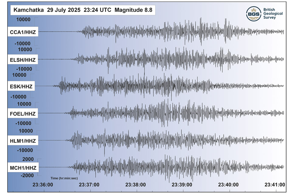

On 29 July 2025, global monitoring systems detected a large earthquake offshore of the Kamchatka Peninsula, Russia, and widespread tsunami warnings were issued across the Pacific region. With a magnitude of 8.8, it was all too easy to think back to the 9.0 to 9.1 magnitude event that devastated Japan in 2011, or the 9.2 to 9.3 magnitude event on Boxing Day in 2004. Thankfully, on this occasion, the impact is believed to be relatively small by comparison.
However, the Kamchatka event did reveal impact of a different nature. Almost as soon as news broke of the earthquake, tsunami warnings were issued and millions of people were told to evacuate across locations at risk, 2 million in Japan alone. This was the result of two decades of research on hazard mitigation following the Boxing Day earthquake in 2004, which claimed the lives of more than 220 000 people in one of the largest disasters, in terms of loss of life, in modern history.
Immediately after the Indian Ocean event in 2004, BGS scientists participated in responsive marine research expeditions that resulted in increased knowledge of sea-bed deformation resulting from the earthquake. Longer-term responses resulted in major advances in understanding earthquake tsunami mechanisms, which have further contributed to disaster risk reduction efforts.
Most significant, in terms of public safety, has been the installation of improved tsunami warnings for coastal communities. Tsunami early warning systems (TEWS) are based on identifying earthquake magnitudes (usually larger than magnitude 7 to 8) that could result in hazardous tsunamis. The Indian Ocean tsunami took two hours to reach the coasts of India, Sri Lanka and Thailand, where around 80 000 people lost their lives. Many of them could potentially have been saved if there had been an operational TEWS in place.
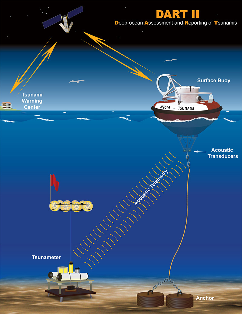
How tsunami wave information in the deep ocean is transmitted to tsunami warning centers. Source: NOAA
In the wake of the catastrophic 2011 Great East Japan Earthquake and Tsunami, further advancements were made in our understanding of tsunami mechanisms, which ultimately led to improved mitigation measures around the world.

Our knowledge base today to plan for and respond to tsunamis is far beyond anything considered possible before the turn of the century.
Following the devastating events of 2004, research has allowed us to be more prepared than ever before to mitigate the threat of this formidable phenomenon. This was highlighted during the Kamchatka earthquake and subsequent tsunamis. TEWS were activated, which led to the evacuation of millions to safety and has ultimately led to a relatively minimal impact being reported.
Prof David Tappin, BGS marine geologist and leading tsunami expert.
Whilst warning systems for earthquake tsunamis are now effectively implemented for major events, there is still the major challenge of designing warning systems for other tsunami mechanisms, such as landslides and volcanic eruptions. Hopefully, with new approaches potentially available through applications such as artificial intelligence, these will become a reality.
Relative topics
Related news

Updated geological assessment of the Southern North Sea set to underpin future offshore infrastructure development
25/03/2026
The first regional assessment for 30 years will support offshore marine and subsurface planning for the UK’s low-carbon energy infrastructure, including the 2030 target of 45 to 50 GW generated through offshore wind.

New research could help provide a more reliable water supply for millions in rural Africa
24/03/2026
A new BGS-led study has revealed crucial insights into the longstanding challenges affecting the reliability and performance of rural water supply infrastructure in sub-Saharan Africa.

Call for new members and Chair to join the NERC facilities steering committees
25/02/2026
New members are needed to join the committees over the next four years.

Your views wanted: developing a geothermal energy subsurface data portfolio
24/02/2026
BGS is aiming to support the growth of the sector by providing the best-available, location-specific geothermal and ground source heat information as an accessible product or service.

Map of BGS BritPits showing the distribution of worked mineral commodities across the country
18/02/2026
BGS’s data scientists have generated a summary map of the most commonly extracted mineral commodities by local authority area, demonstrating the diverse nature of British mineral resources.

Funding awarded to map the stocks and flows of technology metals in everyday electronic devices
12/02/2026
A new BGS project has been awarded Circular Electricals funding from Material Focus to investigate the use of technology metals in everyday electrical items.

New UK/Chile partnership prioritises sustainable practices around critical raw materials
09/02/2026
BGS and Chile’s Servicio Nacional de Geología y Minería have signed a bilateral scientific partnership to support research into critical raw materials and sustainable practices.

Extensive freshened water confirmed beneath the ocean floor off the coast of New England for the first time
09/02/2026
BGS is part of the international team that has discovered the first detailed evidence of long-suspected, hidden, freshwater aquifers.

Funding secured to help mitigate ground risk in UK construction sector
05/02/2026
The BGS Common Ground project has been awarded new funding to help unlock the value of ground investigation data.

Can sandstones under the North Sea unlock the UK’s carbon storage potential?
02/02/2026
For the UK to reach its ambitious target of storing 170 million tonnes of carbon dioxide per year by 2050, it will need to look beyond the current well-studied geographical areas.

Quaternary UK offshore data digitised for the first time
21/01/2026
The offshore wind industry will be boosted by the digitisation of a dataset showing the Quaternary geology at the seabed and the UK’s shallow subsurface.

Suite of ten new soil reference materials released
02/01/2026
BGS has a longstanding track record of producing high-quality reference materials and has released ten new soil reference materials.