Extended seabed geology map of the Bristol Channel published
BGS has released significantly extended high-resolution maps that will support offshore green-energy initiatives in the area.
07/10/2025 By BGS Press

Renewable energy infrastructure, whether on- or offshore, requires in-depth understanding and accurate characterisation of the underlying geology. Developers increasingly need detailed geospatial observations of the seabed and shallow subsurface, which are critical to the siting and design of offshore infrastructure such as submarine cables and offshore wind turbines. This is certainly true in the Bristol Channel, which is home to the second largest tidal range in the world. This high-energy environment has attracted much interest around the use of the seabed for tidal power and the potential to produce electricity from wave energy.
To support policy- and decision makers in this region, BGS has released an enhanced seabed geology map of the Bristol Channel, almost four times the size of the original, which extends from Carmarthen Bay to Newport and further south to the coast of Somerset.
Beyond offshore infrastructure, these maps also directly contribute to understanding of marine ecosystems, coastal management and defence activities. The data provides crucial information to those ensuring the port facilities along this coastline meet the requirements for these development opportunities.
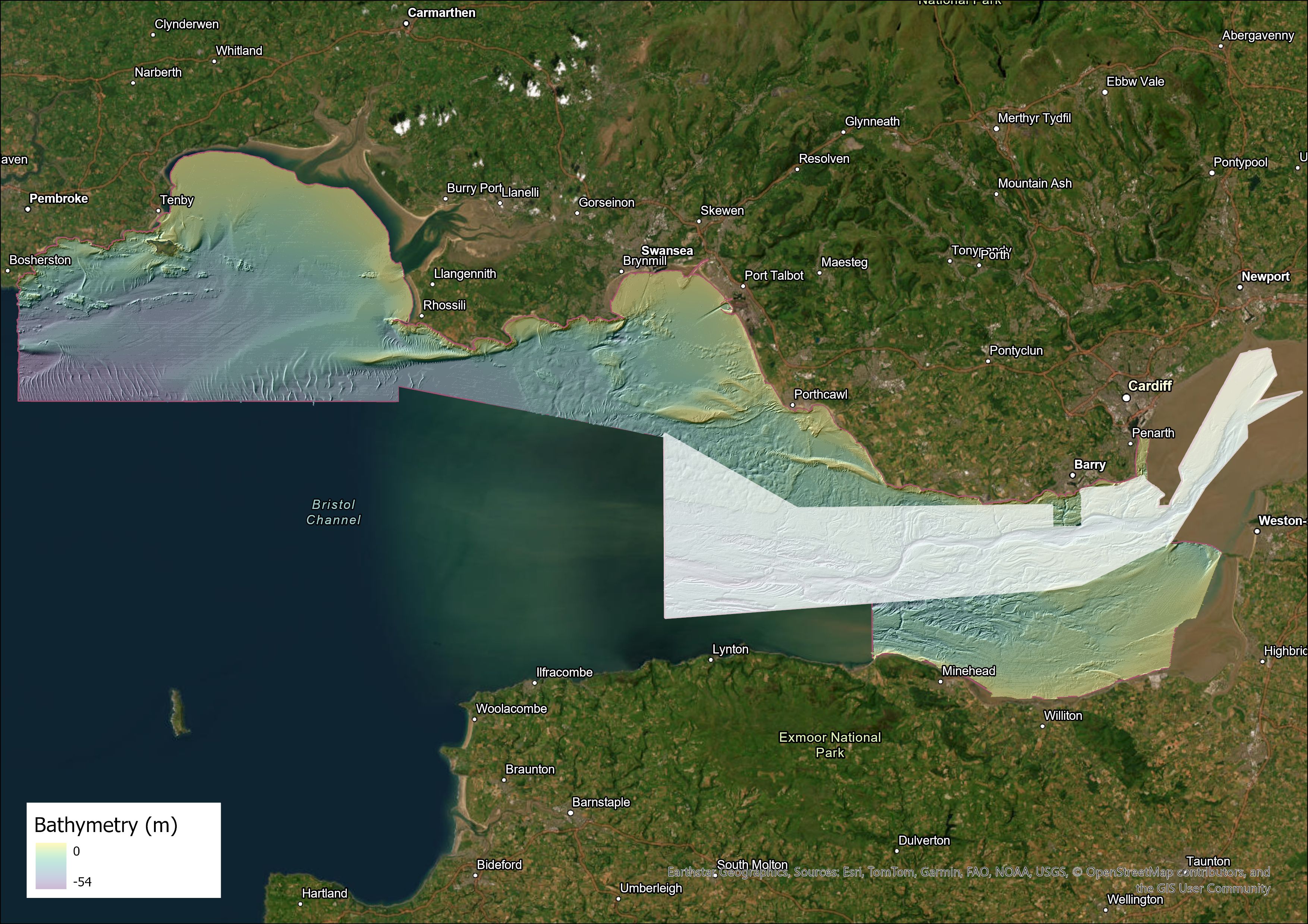
Extent of the extended Bristol Channel map, with the original shown in white. Contains OS data © Crown Copyright and database right 2020. The derived bathymetric layer was produced from Maritime and Coastguard Agency (MCA) data © Crown copyright. Not to be used for navigational purposes. BGS © UKRI.
As the UK’s transition to renewable energy gathers pace, these maps will become increasingly valuable to industry and stakeholders with an interest in developing clean energy, from offshore wind to tidal streaming, and in carbon capture and storage.

The successful implementation of offshore renewable energy projects and technologies and the development of ports in South Wales require a detailed understanding of the seabed. This new, expanded, fine-scale seabed map of the Bristol Channel will be an invaluable resource for developers, providing access to high-quality, detailed observations of the seabed geology that is vital to these kinds of developments.
Beyond its critical role in supporting the renewables sector, the map will also be useful to other data users, such as those involved with supporting marine ecosystems, coastal management and defence activities. It will also provide evidence for policy- and decision makers in the region.
Rhian Kendall, BGS Chief Geologist for Wales.
The map, featuring combined bedrock, sediment, bedrock structure and seabed geomorphology data, is available from BGS under the fine-scale maps section of the Offshore GeoIndex and is designed to be viewed at 1:10 000 scale, or online as downloadable shapefiles. For information on licensing the downloadable GIS data (ESRI format), please contact digitaldata@bgs.ac.uk.
Relative topics
Related news

New research could help provide a more reliable water supply for millions in rural Africa
24/03/2026
A new BGS-led study has revealed crucial insights into the longstanding challenges affecting the reliability and performance of rural water supply infrastructure in sub-Saharan Africa.

Call for new members and Chair to join the NERC facilities steering committees
25/02/2026
New members are needed to join the committees over the next four years.

Your views wanted – developing a ‘Geothermal energy subsurface data portfolio’
24/02/2026
BGS is aiming to support the growth of the sector by providing the best-available, location-specific geothermal and ground source heat information as an accessible product or service.

Map of BGS BritPits showing the distribution of worked mineral commodities across the country
18/02/2026
BGS’s data scientists have generated a summary map of the most commonly extracted mineral commodities by local authority area, demonstrating the diverse nature of British mineral resources.

Funding awarded to map the stocks and flows of technology metals in everyday electronic devices
12/02/2026
A new BGS project has been awarded Circular Electricals funding from Material Focus to investigate the use of technology metals in everyday electrical items.

New UK/Chile partnership prioritises sustainable practices around critical raw materials
09/02/2026
BGS and Chile’s Servicio Nacional de Geología y Minería have signed a bilateral scientific partnership to support research into critical raw materials and sustainable practices.

Extensive freshened water confirmed beneath the ocean floor off the coast of New England for the first time
09/02/2026
BGS is part of the international team that has discovered the first detailed evidence of long-suspected, hidden, freshwater aquifers.

Funding secured to help mitigate ground risk in UK construction sector
05/02/2026
The BGS Common Ground project has been awarded new funding to help unlock the value of ground investigation data.

Can sandstones under the North Sea unlock the UK’s carbon storage potential?
02/02/2026
For the UK to reach its ambitious target of storing 170 million tonnes of carbon dioxide per year by 2050, it will need to look beyond the current well-studied geographical areas.

Quaternary UK offshore data digitised for the first time
21/01/2026
The offshore wind industry will be boosted by the digitisation of a dataset showing the Quaternary geology at the seabed and the UK’s shallow subsurface.

Suite of ten new soil reference materials released
02/01/2026
BGS has a longstanding track record of producing high-quality reference materials and has released ten new soil reference materials.
Perth and Kinross tops the UK’s earthquake activity charts for 2025
29/12/2025
Seismologists at BGS have published data on the number of seismic events over the past 12 months with over 300 earthquakes recorded.