Disaster risk reduction through geoscience
Exploring hazard research at BGS helps us to understand hazard risks and reduce vulnerability to disasters across the globe.
13/10/2022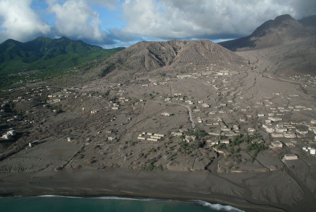

No matter what you frequently hear or read, disasters are not natural. Hazards can be natural (e.g. flooding; landslides; earthquakes; volcanoes) or anthropogenic (e.g. industrial accidents), but it takes exposure and vulnerability of people, assets or infrastructure, for example, to turn a hazard into a disaster.
What is disaster risk reduction?
According to the United Nations Office for Disaster Risk Reduction (UNDRR), disaster risk reduction is the ’development and application of policies, strategies and practices to reduce vulnerabilities and disaster risk throughout society’. Essentially, disaster risk reduction is about finding ways to reduce the impact on anything that can be negatively affected by hazards. Disaster risk reduction measures include, amongst others:
- communication
- education
- implementing building codes
- strengthening existing infrastructure
- adapting farming practices
- hazard monitoring
The list is long! But at the heart of disaster risk reduction is understanding disaster risk – the first priority of the Sendai Framework for Disaster Risk Reduction 2015–2030. And that’s where BGS comes in.
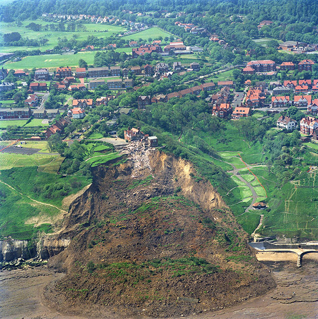
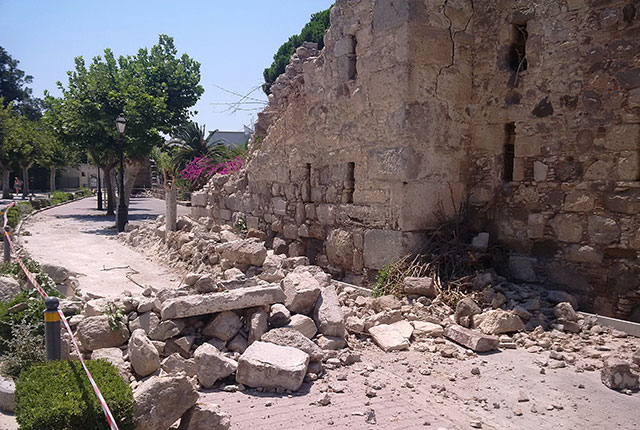
The Holbeck Hall landslide, Scarborough, North Yorkshire, June 1993. BGS © UKRI.
Understanding the hazard
Firstly, we need to understand the processes that lead to a hazardous event or series of events. For example, to better understand a volcano we need to know about its past behaviour:
- how many times has it erupted?
- how frequently does it erupt?
- what were the styles of past eruptions?
- were they predominantly explosive, sending volcanic tephra and gases into the atmosphere, generating pyroclastic density currents (hot, fast-moving flows of volcanic particles and gas)?
- were they predominantly effusive, producing lava flows or lava fountains that reach tens of metres high?
To answer these questions, we rely on geological data. Once we have an idea of what has happened in the past, we can begin to understand which hazards might affect communities in the future.
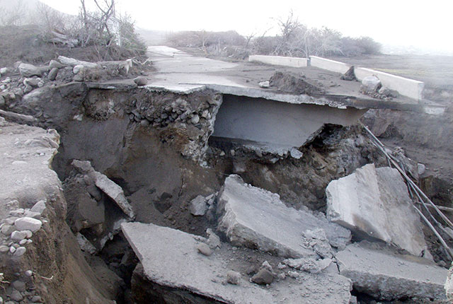
Damaged infrastructure on Montserrat from repeated lahars carving out the embankments along rivers. BGS © UKRI.
The town of Plymouth, Montserrat, with the Soufrière Hills Volcano in the background. BGS © UKRI.
However, the geological data only gives us part of the story. We need to know what the uncertainties are: essentially, what is the geological record not telling us? For example, some events can leave limited geological evidence. Also, just because an event happened in the past does not mean the same event (magnitude and intensity) will happen again. We need to think creatively about future possibilities whilst being guided by the past and learning from other volcanoes (in our example).
That’s where using expert knowledge, scenarios, global data, experimental and numerical modelling comes in. The same is true for other geological hazards such as landslides, earthquakes, tsunamis, and subsidence, all of which we research here at BGS.
The Greek Island of Kos was hit by a 6.7 magnitude earthquake on Friday 21 July 2017 at 1:31a.m., which also triggered a small tsunami. The earthquake killed two people and caused more than 200 injuries. It also caused structural damage across the Island, especially in Kos Town and around the harbour, as well as structural damage in Bodrum, Turkey. BGS © UKRI.
Multi-hazard research at BGS
But BGS is looking exactly into that! The MYRIAD-EU project is a multi-hazard, multi-risk initiative in which BGS and its partners aim to change the way risks are currently assessed and managed in the EU. Stakeholders from various backgrounds and academic and research organisations are co-developing the first harmonised framework for multi-hazard, multi-sector and systemic risk management, with the goal of providing policymakers, decision makers and practitioners with new tools and solutions to reduce and manage risks more effectively.
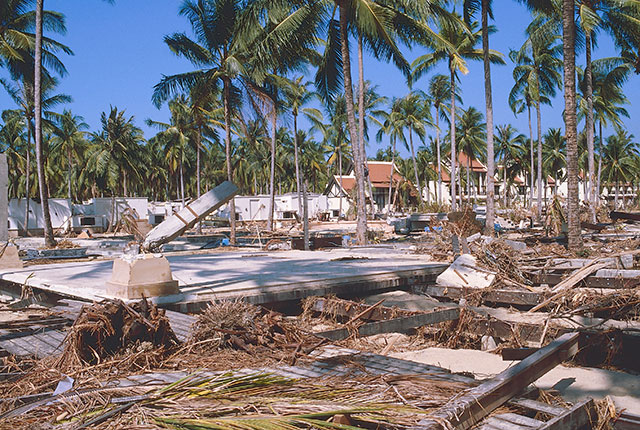
Aftermath of the tsunami that hit Thailand on Boxing Day (26 December) in 2004. BGS researcher Prof Dave Tappin was involved in the response effort in 2004. BGS is now involved in two projects to understand eruptive processes and implications for tsunami initiation at Krakatau, Indonesia. BGS © UKRI.
The project includes staff across BGS’s multi-hazard and resilience and environmental change, adaptation and resilience challenge areas. In the first year of the project, BGS, in collaboration with project partners, has developed two outputs:
- a handbook of multi-hazard, multi-risk concepts, definitions, and indicators used within the project, and hopefully beyond, to provide a common basis for reference terminology for those working in disaster risk reduction
- the Disaster Risk Gateway wiki, an online information resource of multi-hazard, multi-risk assessment and management methods, models and tools
The framework aims to support the wider hazard and risk management community to increase their understanding of what is currently possible and how this knowledge can be applied to different disaster risk (including multi-hazard, multi-risk) challenges. Both resources are designed to support and strengthen collaborations across disciplines, sectors and communities.
As Esline Garaeti, Director General of the Ministry of Climate Change Adaptation, Meteorology, Geo-Hazards, Environment, Energy and Disaster Management in Vanuatu and recipient of the Women’s International Network for Disaster Risk Reduction Leadership Awards for Excellence, 2022, said: ‘If you understand the risk, then you can understand how to cope with it.’ That is why geoscience is an essential part of disaster risk reduction.
More information
Many researchers across BGS work together on multiple projects to understand hazard processes and analyse potential hazards and risks. We study:
One example of our work involved numerical modelling of volcanic hazards in the Main Ethiopian Rift.
To find out more about our research, check out the BGS website to see the variety of initiatives we work on.
Here are some more great resources for learning more about disaster risk reduction:
- Sendai Framework for Disaster Risk Reduction 2015–2030
- PreventionWeb: the global knowledge-sharing platform for disaster risk reduction and resilience
- Global Platform for Disaster Risk Reduction 2022
- Ten things you should know about disaster risk reduction: a 4-minute video developed by the Humanitarian Policy Group
About the author
Crummy Julia
Senior volcanologist