BGS to support novel scientific ocean drilling expedition to explore Arctic Ocean palaeoceanography and climate
BGS is pleased to be part of a joint IODP expedition focused on the Arctic Ocean, a key location in global climate change.
18/02/2021 By BGS Press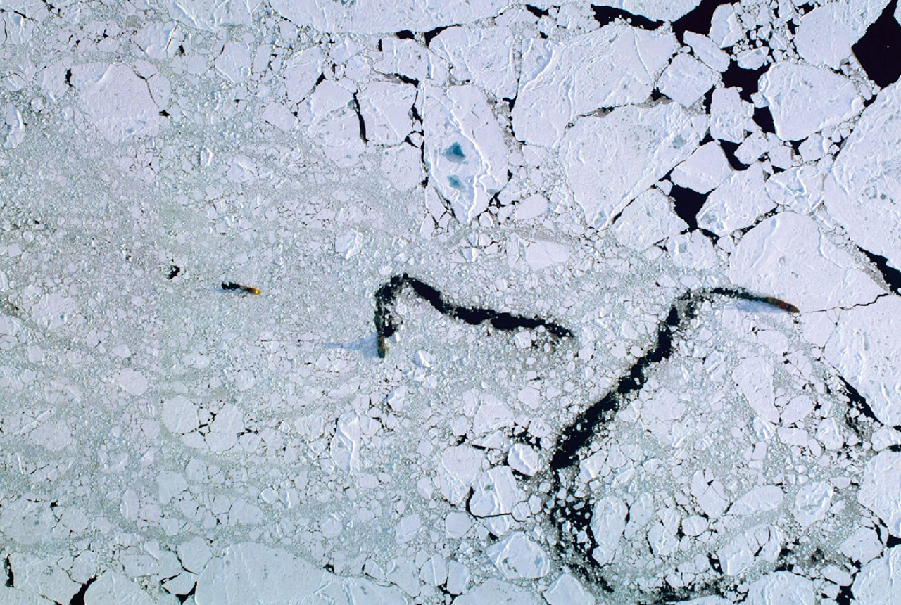

BGS is pleased to be part of a joint expedition of the International Ocean Discovery Program (IODP), focused on the Arctic Ocean – a key location in global climate change.
Despite its global importance, the Arctic Ocean is the last major region on Earth where the long-term climate history remains poorly known.
IODP Expedition 377 Arctic Ocean Paleoceanography – or ArcOP – will represent a step-change in reconstructing the detailed history of climate change in the central Arctic Ocean over the last 50 million years.
A joint expedition, it will involve expertise from the European Consortium for Ocean Research Drilling (ECORD), the Swedish Polar Research Secretariat (SPRS) and Arctic Marine Solutions (AMS) and is planned to take place in August and September 2022.
![]()
Science behind the ArcOrp Expedition
The Arctic Ocean is a very sensitive and important region for global climate change, and is unique in comparison to the other oceans on Earth. Due to complex feedback processes (collectively known as “Arctic amplification”), the Arctic is both a contributor to climate change and a region that is most affected by global warming.
Major advances in understanding were achieved in 2004 when the successful completion of IODP Expedition 302: Arctic Coring Expedition – ACEX, also implemented by ECORD, marked the start of a new era in Arctic climate exploration.
The ArcOP expedition will explore a critical time interval, spanning the period when prominent changes in global climate took place during the transition from the early Cenozoic Greenhouse world to the late Cenozoic Icehouse world.
An international team of scientists will collect about 900 m of sediment cores at two sites along the Lomonosov Ridge.

We anticipate that the sedimentary record that the Arc-OP expedition is targeting will provide critical puzzle pieces enabling the scientific community to better understand the drivers, feedbacks, consequences, and varying rates of Cenozoic climate change at both regional and global scales.
Prof Kristen St John, ArcOP Co-chief Scientist.
A unique and challenging expedition, a fleet composed of a scientific drillship supported by two icebreakers will be used to make drilling possible in this permanently ice-covered region.
Such a multi-vessel approach was employed by ECORD for the first time during the ACEX Expedition in 2004.
The expedition will last for about seven weeks offshore and will be followed by intensive investigation and sampling of the cores onshore to unlock their climate secrets.
BGS will help to lead the implementation of the expedition through its role as the co-ordinator of the ECORD Science Operator (ESO), in close collaboration with SPRS and AMS.
BGS staff are excited to be part of this ambitious IODP expedition that will see us manage, co-ordinate and support an international team of scientists through our role as the coordinator of the ECORD Science Operator.
Our role is very much to support the team’s efforts to uncover and understand the history of climate change in the central Arctic Ocean over the last 50 million years.
We will provide expedition management and coring oversight, and work with our partners to provide facilities and services for the curation, databasing, archiving and analysis of collected cores and samples, and downhole logging services.
David McInroy, BGS Geoscientist.
Further details of the expedition can be found on the ECORD website.
More information
- ArcOrp expedition
- IODP research programme
- ECORD Science Operator (ESO)
- Swedish Polar Research Secretariat (SPRS)
- Arctic Marine Solutions (AMS)
Related news

New research could help provide a more reliable water supply for millions in rural Africa
24/03/2026
A new BGS-led study has revealed crucial insights into the longstanding challenges affecting the reliability and performance of rural water supply infrastructure in sub-Saharan Africa.

Call for new members and Chair to join the NERC facilities steering committees
25/02/2026
New members are needed to join the committees over the next four years.

Your views wanted – developing a ‘Geothermal energy subsurface data portfolio’
24/02/2026
BGS is aiming to support the growth of the sector by providing the best-available, location-specific geothermal and ground source heat information as an accessible product or service.

Map of BGS BritPits showing the distribution of worked mineral commodities across the country
18/02/2026
BGS’s data scientists have generated a summary map of the most commonly extracted mineral commodities by local authority area, demonstrating the diverse nature of British mineral resources.

Funding awarded to map the stocks and flows of technology metals in everyday electronic devices
12/02/2026
A new BGS project has been awarded Circular Electricals funding from Material Focus to investigate the use of technology metals in everyday electrical items.

New UK/Chile partnership prioritises sustainable practices around critical raw materials
09/02/2026
BGS and Chile’s Servicio Nacional de Geología y Minería have signed a bilateral scientific partnership to support research into critical raw materials and sustainable practices.

Extensive freshened water confirmed beneath the ocean floor off the coast of New England for the first time
09/02/2026
BGS is part of the international team that has discovered the first detailed evidence of long-suspected, hidden, freshwater aquifers.

Funding secured to help mitigate ground risk in UK construction sector
05/02/2026
The BGS Common Ground project has been awarded new funding to help unlock the value of ground investigation data.

Can sandstones under the North Sea unlock the UK’s carbon storage potential?
02/02/2026
For the UK to reach its ambitious target of storing 170 million tonnes of carbon dioxide per year by 2050, it will need to look beyond the current well-studied geographical areas.

Quaternary UK offshore data digitised for the first time
21/01/2026
The offshore wind industry will be boosted by the digitisation of a dataset showing the Quaternary geology at the seabed and the UK’s shallow subsurface.

Suite of ten new soil reference materials released
02/01/2026
BGS has a longstanding track record of producing high-quality reference materials and has released ten new soil reference materials.
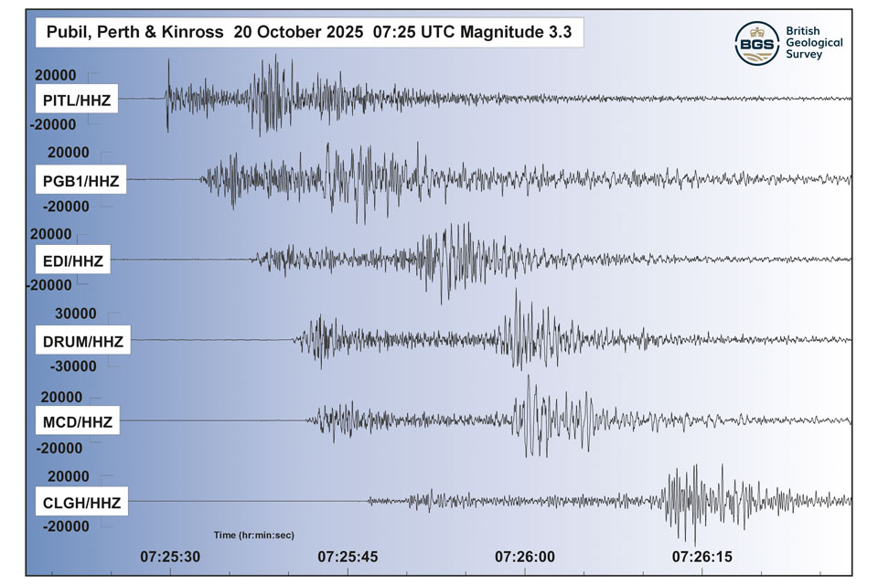
Perth and Kinross tops the UK’s earthquake activity charts for 2025
29/12/2025
Seismologists at BGS have published data on the number of seismic events over the past 12 months with over 300 earthquakes recorded.