During February 2014, there was a significant increase in the number of sinkholes occurring across the UK, particularly but not exclusively, in the south-east of England.
In February 2014, a sinkhole formed adjacent to the slip road off the northbound carriageway of the A38 at Caton, Devon. This event, which was significant in terms of its size and potential impact, was not brought to the attention of the BGS until April 2016. This coincided with a project defining karst domains across the UK and therefore a responsive visit was made in June 2016 to provide additional project information.
Sinkhole description
By the time of the visit, the sinkhole had been partially remediated by backfilling. A remnant depression of at least 3 m depth and 5 m diameter was still evident immediately adjacent to the slip road (Figure 1). Evidence from twelve investigation boreholes along a north-east to south-west transect of approximately 135 m commissioned by EM Highways Services Limited confirms that this is an area of buried karst. The borehole records have been lodged with the BGS and, although they are not sufficient to determine the full depth of the associated karst, they confirm that it exceeds 49.50 m in one of the boreholes and 45 m in two of the others.
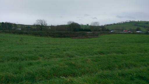

Figure 1: Surface depression remnant from sinkhole adjacent to the A38 at Caton, Devon. BGS © UKRI.
Geographical and geological setting
Caton is a small village or hamlet approximately 2 km to the north-east of Ashburton and 20 km to the south-east of Dartmoor in Devon. The sinkhole was situated at NGR 27837 7203, on the western side of the slip road and in the order of 1 km to the north-east of Linhay Hill Quarry. The quarry has been excavated on the north-eastern edge of the former stannary (tin mining) town of Ashburton. The A38 is one of two main routes into Cornwall and therefore is particularly vulnerable should major roadworks be required.
The geology (Figure 2) is complex because the area has been subject to thrust faulting, so that older rocks were thrust over younger rocks during the tectonic movements associated with mountain building (the Variscan Orogeny). Consequently at Caton, the geology comprises Middle Devonian limestone (Chercombe Bridge Limestone Formation; 380 to 360 million years old) overlying the younger, Upper Devonian Tavy Formation (formerly known as the Kate Brook Slate Formation) comprising slaty, silty mudstone with minor thin sandstone beds, which has been thrust against the Upper Carboniferous Crackington Formation of the Holsworthy Group.
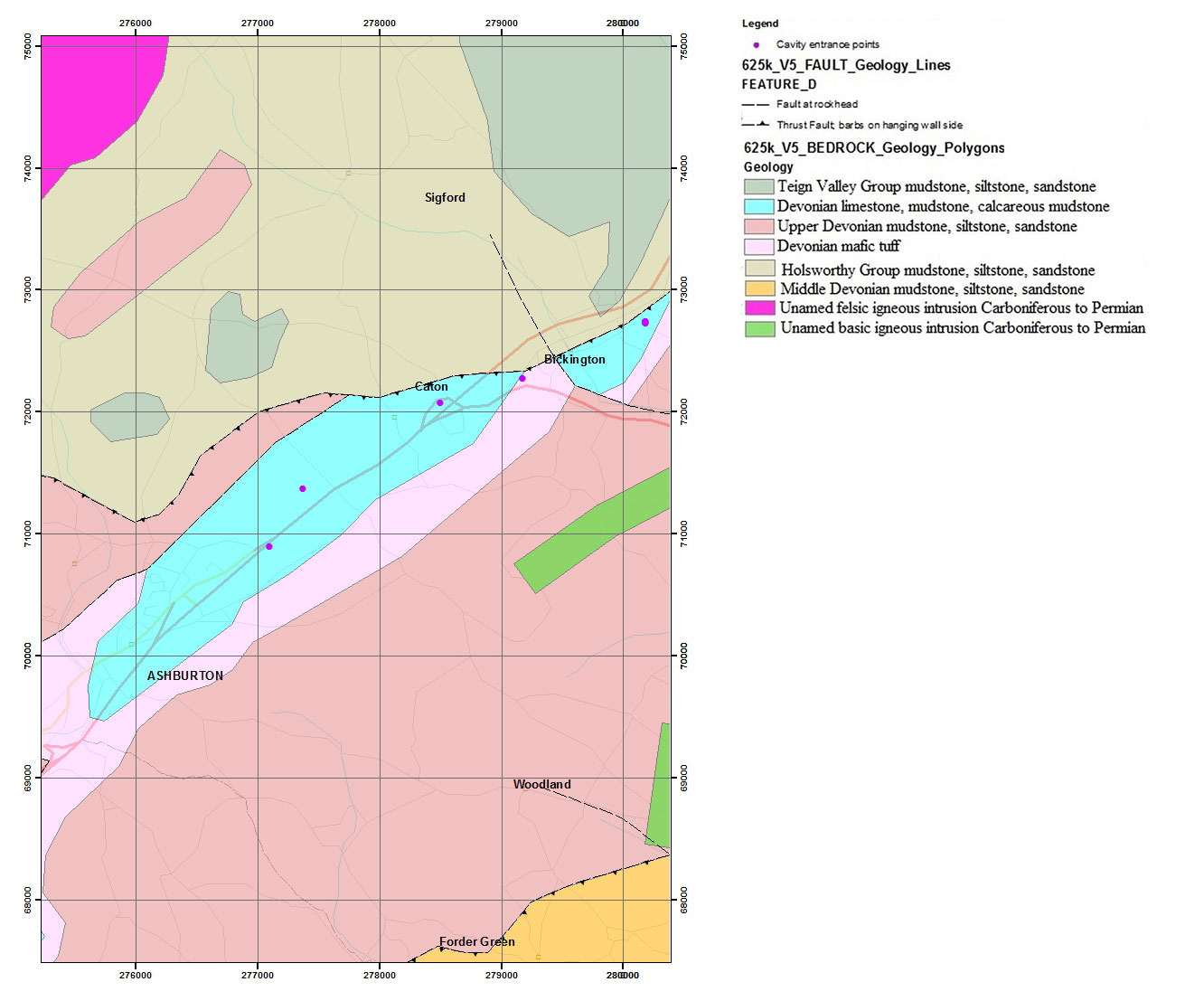
Figure 2: bedrock map of the Caton area. BGS © UKRI. Contains Ordnance Survey data © Crown copyright and database rights. All rights reserved 2020 Ordnance Survey [100021290 EUL].
The BGS 1:50 000 provisional series solid and drift sheet 338 (Dartmoor Forest) shows the beds of the Chercome Bridge Limestone Formation dipping 33 to 43 degrees to the south-east, reflecting the dip of the thrust faults. The north–south compressional forces associated with the Variscan Orogeny resulted in thrusting along an approximately east–west lineation, represented by the Bickington Thrust Zone. In the area of the sinkhole, with the exception of ribbons of alluvium associated with the dry valleys that cross the area, the mapping shows limestone to the surface.
Karst characterisation
Karst is the term applied to topography formed by the dissolution of soluble rocks such as limestone, as a consequence of fluids moving across and through them. Karst can also form by upward-moving fluids, such as those that are introduced during mineralisation, e.g. the silver-bearing fluids that also occur in this area. Areas of karst are usually characterised by the distribution of caves, sinkholes (dolines, or doline groups (ponors); points of surface water recharge), springs (points of resurgence of water passing through the rock) and dry valleys. The rate of dissolution can be increased by the introduction of more acidic water or increased rates of fluid flow through the rock.
The development of karst topography occurs at a range of scales (Figures 3a–3e). It is influenced by a number of factors, such as the distribution of fractures in the rock (bedding and jointing related) and the variation in the lithology (physical composition) of the rock. Here, the complex structural history has imposed significant fracturing of the rock, providing many surfaces along which dissolution might occur. Preferential flow paths form between the recharge and discharge points, their positions reflecting the local hydraulic gradient (gradient of the ‘water table’ at the time of formation). They can be traced using tracers.
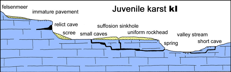
Figure 3a: juvenile karst (Waltham and Fookes, 2005).
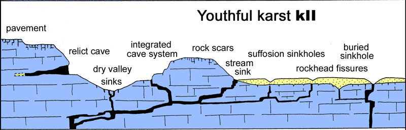
Figure 3b: youthful karst (Waltham and Fookes, 2005).
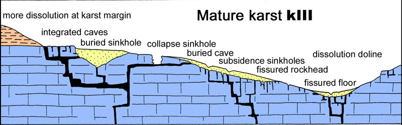
Figure 3c: mature karst (Waltham and Fookes, 2005).
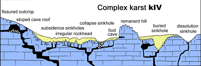
Figure 3d: complex karst, Engineering classification of karst (Waltham and Fookes, 2005).
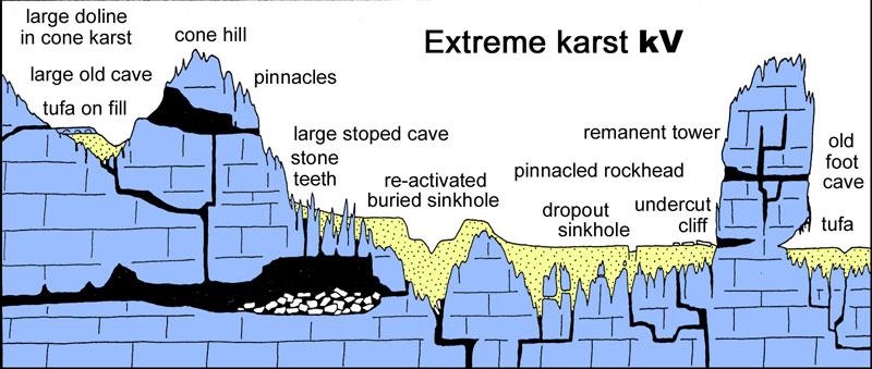
Figure 3e: extreme karst, Engineering classification of karst (Waltham and Fookes, 2005).
Buried karst
Although not shown on the geological map, the karst topography at Caton has been overlain by younger sediments to form a setting to which the term ‘buried karst’ is applied. The area of this karst is evident from the digital terrain model (Figure 4). It comprises a smooth, basin-shaped, ovoid area centred on a north-east to south-west axis.
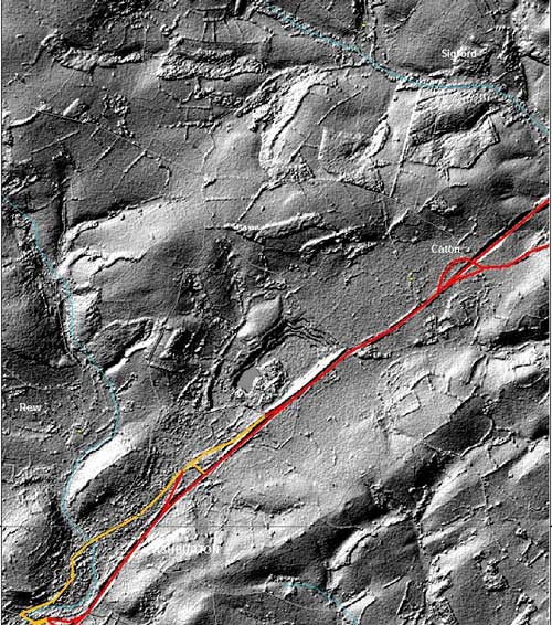
Figure 4: buried karst around Caton. NEXTMap Britain elevation data from Intermap Technologies (Ordnance Survey Licence No. 100021290 EUL).
Obviously it is more difficult to characterise karst that has been buried. However, there are some clues: for example, caves are known to have formed in these limestones, e.g. the Pridhamsleigh cavern, Buckfastleigh caves, Bickington pot and Lemonford caves (William Pengelly Cave Studies Trust). Additionally, some of the karst has been exposed by engineering.
There is a potential geological interest in the clastic sediments that cover the karst. Evidence from the borehole logs suggests that these sediments comprise clay with limestone, mudstone, sandstone and quartz gravel. The suspected presence of lignite (soft brown coal) in one of the samples suggests a possible Tertiary (66 to 2.58 million years old) age for the clays.
Anthropogenic impacts
Karst environments are sensitive to anthropogenic (human-induced) impacts, including groundwater lowering to exploit minerals beneath the water table. This has the effect of focusing flow through drainage and point discharge and diverting flow paths.
Significant historical impacts are associated with early exploitation of minerals and would be expected in the vicinity of a stannary town. There are five historic mines in the order of 2 km to the north-west of this area of karst: Whiddon, Beam, Union, Stormsdown and Owlacombe mines. These are tin and copper mines that were operational during the eighteenth and nineteenth centuries (Hamilton Jenkin, 2005). The mines were drained via adits to the lower ground to the south-east of them. Many of the adits still discharge groundwater.
The copper and tin mineralisation is associated with the mineral pyrite (iron sulphide), which can be oxidised to form weak solutions of sulphuric acid that lowers the pH of the mine water, thus making it more aggressive to limestone.
Another effect of historic mining is the legacy of lime kilns that form a source of calcium carbonate for secondary carbonates, e.g. carbonate cements, speleothems (stalagmites and stalactites) and tufa (redeposited calcium carbonate) in cave systems.
Implications for engineering
Buried karst can present significant problems to engineering for a number of reasons:
- voids may be encountered unexpectedly at a range of depths
- the buried karst topography can undulate significantly, resulting in variable depth to competent strata and therefore variable founding conditions
- cavities at depth can accommodate sediment that is mobilised through the karst system
- weathering beneath the overlying sediment weakens the limestone, thereby adding to the variable and unpredictable ground conditions for engineering
Groundwater conditions can be very variable in karst ground. The implications of the Middle Devonian limestone karst were realised during the construction of the Caton Cross bypass in the 1970s (Fookes and Hawkins, 1988) and the Linhay Hill diversion (Malkin and Wood, 1972). At Caton Cross, variable ground conditions were revealed with respect to the thickness of the clastic cover as well as in the bedrock lithology. During construction it was clear that this was an area of pinnacle karst (Figure 3e) with some of the rock pinnacles requiring drilling and blasting. At Linhay Hill, a higher-level network of caves was encountered at the formation level.
Karst can be classified, in terms of its maturity, for engineering purposes.
Potential research directions
Descriptions of the karst around Caton are limited, but it is clear that there is considerable research opportunity in this area with a potential to draw on the interplay between aspects of applied and pure geology. The contrast between the nearby Linhay Hill karst and the buried karst may provide insights with respect to palaeogeographical understanding. The depth of the karst offers the potential to provide useful insights into the uplift history of the area.
Additional evidence from the site suggests that there are a number of smaller dolines in the area, e.g. the dip in the hedge line in Figure 5, that warrant further research with respect to formation processes and hydrological functioning, particularly given the potential impact of karst development on the road infrastructure.
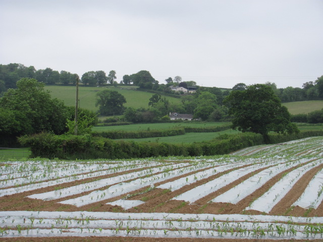
Figure 5: dolines in buried karst. BGS © UKRI.
Road networks, such as the A38, form major arteries that support business, including tourism, in the south-west. They connect people in rural communities with services and amenities as well as providing a means of transporting goods and freight. Understanding the geology of a karstic area such as this provides an important contribution to the maintenance of rich, precise and up-to-date information for service providers.
References
Fookes, P G, and Hawkins, A B. 1988. Limestone weathering: its engineering significance and a proposed classification scheme. Quarterly Journal of Engineering Geology, Vol. 21, 7–31. DOI: https://doi.org/10.1144/GSL.QJEG.1988.021.01.02
Hamilton Jenkin, A K. 2005. Mines of Devon. (Landmark Publishing.)
Malkin, A B, and Wood, J C. 1972. Subsidence problems in route design and construction. Quarterly Journal of Engineering Geology, Vol. 5, 179–194. DOI: http://www.doi.org/10.1144/GSL.QJEG.1972.005.01.17
Waltham, A C, and Fookes, P G. 2003. Engineering classification of karst ground conditions. Quarterly Journal of Engineering Geology, Vol. 36, 101–118. DOI: https://doi.org/10.1144/1470-9236/2002-33
Contact
If you want to discover more, please contact BGS Enquiries.
You may also be interested in
Sinkholes and karst research
Our research extends beyond the distribution and processes associated with sinkhole formation to the broader subject of karst.