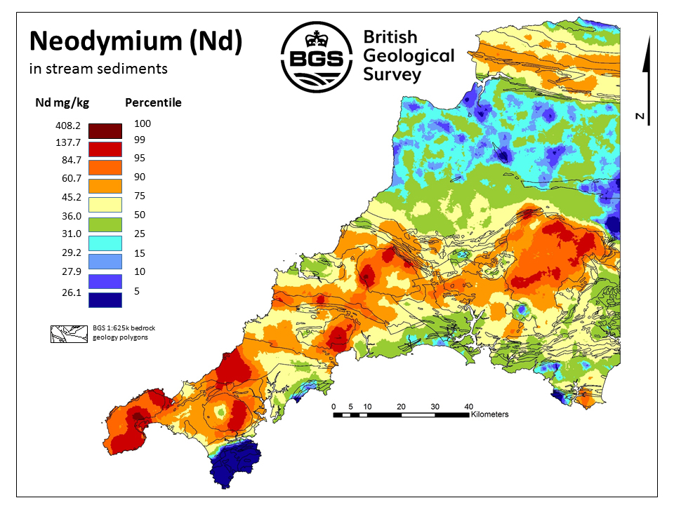

SW England REE stream sediment sample. BGS © UKRI – Contains OS data © Crown copyright 2020.
South-west England rare earth element stream sediments
- Partial Great Britain coverage: south-west England
- Open / Premium
The dataset consists of a series of interpolated raster (ASCII) grids and maps displaying the distributions of rare earth elements in stream sediments in south-west England.
Key information
- Coverage:
- Partial Great Britain coverage: south-west England
- Availability:
- Open / Premium
- Price:
Gridded data free for commercial, research and public use under the Open Government Licence.
Survey point data available under licence on request.
- Format:
- ASCII grid data (500 m cell size). Printable maps in pdf format. Database tables for survey points.
- Uses:
- Local-level use
- Themes:
- Geochemistry
- Sector:
- Environmental protection
Rare earth elements (REE) are naturally occurring chemical elements that are found in a wide range of geological environments. They are a group of chemically similar, metallic elements that are of increasing interest because they have a variety of applications:
- a diverse range of consumer electronics (including mobile phones)
- environmental technologies (including batteries and wind turbines)
- industrial applications
The dataset consists of a series of interpolated raster (ASCII) grids and maps displaying the distributions of the REEs in stream sediments in south-west England.
Download the data
South-west England REE interpolated maps and grids with a supporting user guide are available to download.
- Download all ASCII grids for south-west England REE stream sediments
- Download all PNG maps for south-west England REE stream sediments
More information on REE
You may also be interested in
Data search
Accessing the more than 400 datasets that data-rich BGS holds in its care.
UK: Stream sediment geochemistry
The UK stream sediment geochemistry maps present data compiled from the G-BASE and TellusNI geochemical projects.
UK and world mineral statistics datasets
The British Geological Survey (BGS) has one of the largest databases in the world on the production and trade of minerals.
Mineral resources
This dataset contains the geological distribution of all onshore mineral resources.