A large landslide occured on the northern Cornwall coast on the afternoon of Friday 23 September 2011. Richard Hocking and Brian O’Connell, engineers at Cornwall Council, filmed the event, which was a large rock slide/fall near Hell’s Mouth, between Portreath and St Ives. A landslide on this scale is unusual in the south-west of England and the opportunity to witness it extremely rare.
Rapid failure
The rock slide/fall appears to have developed progressively from the foot of the cliff and taken out a significant section of cliff top in about 20 seconds. However, tension cracks had been noted in the cliff-top three days previously by council engineers.
Cliff geology
Geologically, the cliff consists of mudstones and sandstones of the Porthtowan Formation and slates/siltstones of the Mylor Slate Formation, both of Devonian age.
These rock materials are weathered and have variable strength. The rock material that failed, at least on the evidence of the video, appeared to be in a dry state.
There is a complex interrelationship of regional faulting and local jointing, which allows the rock mass to divide into blocks which with time become unstable.
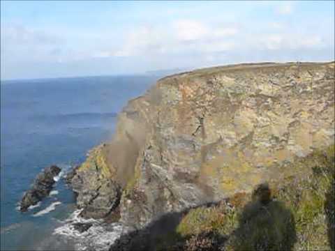


A large rock slide/fall near Hell’s Mouth between Portreath and St Ives, on the North Cornwall coast.
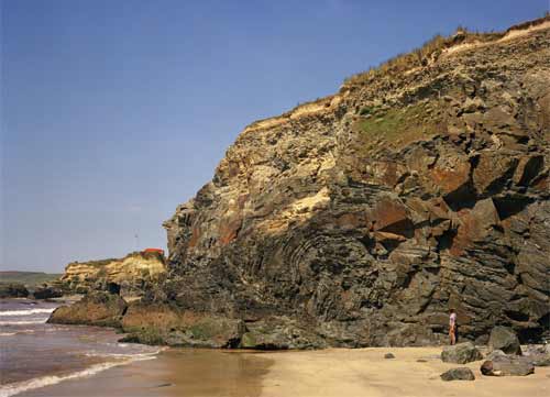
Nearby geology at Gwithian Towans; folding in Mylor Slates. An anticline with a near-horizontal hinge in silty banded slates. The cliff is capped by head overlain by blown sand. BGS © UKRI.
Five days warning
On 19 September 2011, a jogger had reported that a large crack had developed in the coastal path. Later that day, Cornwall Council decided to divert the path, working with the landowners The National Trust.
Further surveys by Cornwall Council on 22 September 2011 observed that the failure had progressed and that large tension cracks were opening up. On 23 September 2011, reports of material falling from the cliff were noted throughout the day. The cliff collapsed by about 4.50 p.m.
You may also be interested in

Landslide case studies
The landslides team at the BGS has studied numerous landslides. This work informs our geological maps, memoirs and sheet explanations and provides data for our National Landslide Database, which underpins much of our research.

Understanding landslides
What is a landslide? Why do landslides happen? How to classify a landslide. Landslides in the UK and around the world.

How to classify a landslide
Landslides are classified by their type of movement. The four main types of movement are falls, topples, slides and flows.

Landslides in the UK and around the world
Landslides in the UK, around the world and under the sea.