Key information
- Availability:
- NA
- Themes:
- Engineering geology, Hazards
BGS GeoSure data is provided as a series of layered themes. Depending on the scale of data chosen, up to five main themes are available.
Example datasets
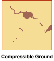
The area around Dundee is mainly underlain by sandstones, siltstones and mudstones of Devonian age. To the north-west, in the Sidlaw Hills, and to the south-east, along the southern shore of the Firth of Tay, volcanic rocks of similar age crop out. Small outcrops of intrusive igneous rocks occur under Dundee itself and between Dundee and the Sidlaw Hills.
However, the bedrock geological formations are almost entirely covered by much younger (Quaternary) geological deposits. Glacial till predominates below Dundee and to the north, while along the Firth of Tay and to the south, alluvial deposits and peat are well represented.
Potentially significant geological hazards
Compressible material is associated with the alluvial deposits of the River Tay, which may contain layers of peat or interbedded clay, silt and sand, with small, isolated deposits of peat elsewhere in the area.
Deposits containing sand, which may become mobilised by flowing water (running sand), may be present in sandy alluvial deposits associated with the River Tay and other rivers and streams within the area. Potentially running sand deposits may also be present in deposits left by rivers and streams that were active when the ice melted at the end of the last glaciation (fluvio-glacial deposits). Since these deposits are not usually associated with current drainage networks, they may not be saturated with water and are less likely to have the conditions for running sand to occur.
There are no significant outcrops of limestone, gypsum or halite in the area and problems due to soluble rocks are not likely to be present.
No areas with a significant potential for natural landslide activity have been identified, at the scale of the assessment. However, it is possible that small-scale instabilities may be present below the limits of resolution of the assessment, particularly where natural or artificial slopes meet strata with adverse dips of jointing or bedding.
No strata or deposits containing significant amounts of clay with a high potential for volume change have been identified in the area and problems due to shrink–swell clay subsidence are unlikely to occur.
The upland moorland to the north of the area comprises sandstone and siltstone strata of the Carboniferous Millstone Grit Group. These rest on Carboniferous mudstone, sandstone and shale strata, which are exposed in the valley bottoms and along the southern margin of the sandstone outcrop. To the south of the area the mudstones and shale rest unconformably on massive Carboniferous limestone.
The area was not covered by ice during the last glaciation and the landforms of the earlier glaciation have been much modified by periglacial processes during the last ice age. Thus there are only a few areas with a covering of till but large expanses of head. The upland moorland is covered by extensive deposits of peat.
Significant geological hazards
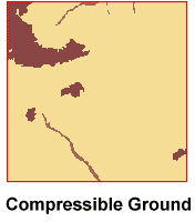
Compressible ground is present where there is a significant thickness of peat, mainly on the high moorland, and in patches of stream alluvium where there is a possibility of layers of peat or interbedded, saturated clay, silt and sand. There is a small possibility of running sand conditions within saturated sand layers within deposits of alluvium along streams. There is a small potential for shrink–swell clay subsidence to be associated with some of the Carboniferous mudstones and Quaternary clay till.
There are several areas where there is a significant potential for landslides hazard to be present, including areas of currently active landslides (Mam Tor). These areas are particularly associated with steep valley sides formed by thick sandstones resting on impermeable mudstones where a strong springline forms at their junction. The water from the spring line saturates the mudstone and overlying superficial deposits, such as head, lowering their strength and promoting failure of the slope.
The limestone area exposed at the south of the area is well known for the caves and it contains, several of which have been developed as tourist attractions. Although the sudden collapse of natural caves causing subsidence at the surface is an extremely rare event, there is a significant potential for hazards associated with the potential for material to subside into ancient collapse features as their infilling material settles. The possibility of loose material on the surface being washed into subterranean voids under the influence of surface-water drainage is a more common cause of surface subsidence.
The Brecon Beacons mountains to the north of the area are formed by thick, strong, southward-dipping, Devonian sandstone strata. To the south, initially thick, strong, Carboniferous limestone strata and further south, mudstones, siltstones and sandstones of Carboniferous Coal Measures strata are exposed. In the southern part of the area there are areas of much younger deposits (Quaternary) that cover a large proportion of the bedrock formations. In the river valleys these comprise alluvium composed of varying amounts of clay, silt, sand and gravel. In between the valleys and draped over much of the area is a cover of glacial till. To the north there is a less continuous cover of superficial material that is largely restricted to alluvium in river and stream valleys and a cover of peat on part of the sandstone upland.
Potentially significant geological hazards
Significantly compressible material is found mainly in the river alluvium, which may contain layers of peat or interbedded clay, silt and sand, and where there is significant thickness of peat on the upland to the north of the area. Deposits containing sand that may become mobilised by flowing water (running sand) may be present in sandy alluvial deposits associated the rivers and streams within the area.
The formations present in the area do not generally contain highly plastic clays that would cause a significant hazard due to shrink–swell clay subsidence. The greatest potential is in the alluvium that may have some weathered clay deposits within it of medium plasticity.
The greatest potential for landslide activity is on the steep valley sides in the more mountainous areas and, to a lesser extent, the northern slopes of the Brecon Beacons.
The limestone area that extends east to west across the area to the north of Merthyr Tydfil is well known for its limestone caves and there is a significant potential for hazards associated with them. Although the sudden collapse of caves causing subsidence at the surface is very rare, the potential for material to subside into collapse features as their infilling material settles or for loose material on the surface to be washed into subterranean voids is a common cause of surface subsidence.
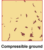
The area is mainly underlain by silty clay of the Eocene London Clay Formation. Outcrops of the silty Claygate Member of the London Clay, capped by the sandy Bagshot Formation, occur near Loughton and Chigwell. To the north and north-west, the London Clay has been eroded to expose the clay, silt and sand of the Lambeth Group and, below these, outcrops of the Cretaceous Lewes Nodular Chalk Formation.
Much of the bedrock is overlain by much younger (Quaternary) geological deposits. Along the valley of the River Lea, alluvium, comprising varying amounts of sand silt clay and gravel, predominates while towards the valley sides sand and gravel terrace deposits of former river levels are found together with deposits of silty clay river deposits. Further from the river valley, deposits of glacial till are present together with deposits of sands and gravels left by rivers and streams that flowed as the ice melted at the end of the last ice age.
Potentially significant geological hazards
Compressible material is restricted to the alluvial deposits, along the River Lea and streams, which might contain layers of peat or interbedded clay, silt and sand.
Deposits containing sand that may become mobilised by flowing water (running sand) may be present in sandy alluvial deposits associated with the River Lea and streams within the area. Potentially running sand deposits may also be present in deposits left by rivers and streams that were active when the ice melted at the end of the last glaciation (fluvio-glacial deposits). Since these deposits are not usually associated with current drainage networks, they may not be saturated with water and are less likely to have the conditions for running sand to occur.
The London Clay Formation contains significant amounts of high-plasticity clay that can result in shrink–swell clay subsidence due to volume changes associated with drying out at times of drought or trees with a high moisture demand. Where there is a sufficient covering of superficial deposits that do not contain clay, the potential for shrink–swell subsidence is much reduced.
The course of the River Lea is associated with deposits of river silts (the Enfield silts) that may have a very open structure with a potential for collapse if they become wetted under load or are subjected to an excessive load. However, it is likely that these silts have been reworked by the river and the open structure has been destroyed but the potential for collapse should be considered in decisions about land use and construction associated with these deposits.
In general there is little potential for natural landslides in this area except where steep slopes are formed by the London Clay Formation, particularly where there is a spring at the base of the overlying Claygate Member that promotes saturation and weakening of the underlying London Clay. Areas where this may be significant include to the north of Chingford and to the north of Waltham Abbey.
The outcrop of the Lewes Chalk on the north and north-west margins of the area may have a significant potential for dissolution hazards, especially near to the outcrop of the less permeable strata to the south. Water draining off the clays may be concentrated along the junction with the chalk and cause solution of the chalk to form dolines or swallow holes. These are sites of weakness that may cause subsidence of structures built over them as they continue to dissolve, compress or as overlying fine material is washed into them.
You may also be interested in


BGS GeoSure
The BGS GeoSure datasets identify areas of potential hazard and, therefore, potential natural ground movement, in Great Britain.